The Calamitous Climate Responsible for Florida’s Record Rainfall

Photo by Marianna Massey/Getty Images
As severe weather marches northeast on Wednesday, Florida residents are drying out after ludicrous levels of overnight rainfall.
The National Weather Service called the event “historic.” The official rain gauge at Pensacola’s airport measured an astonishing 5.68 inches in a single hour before it failed around 10 p.m. Tuesday. An analysis by the NWS office in Mobile, Alabama, estimated that single hour to be a 1-in-200- to 1-in-500-year event. The official rain gauge and weather radar both gave out, presumably from lightning strikes, so we might never know exactly how much rain fell Tuesday night.* Still, several unofficial rain gauges measured impressive totals.
One flabbergasted Pensacola resident live-tweeted his rain gauge throughout the night, ending up with more than 2 feet of rain:
In the last 26 hours, 24.4 inches of rain have fallen in Pensacola. #flwx pic.twitter.com/TlpprNknP4
-- Rob McGahen (@rmcgahen) April 30, 2014Incredible as it sounds, that measurement was backed up by radar estimates:
Here is DP radar data over 22" of rain massive flooding. Water rescues are on going now.#flwx #alwx pic.twitter.com/nE2Ajs7Smw
-- Jeff Piotrowski (@Jeff_Piotrowski) April 30, 2014Pensacola’s highest previous midnight-to-midnight rainfall total was 15.29 inches, during a land-falling tropical storm in October 1934. Local rainfall records go all the way back to 1879, so it’s possible that Tuesday’s storms produced the heaviest rainfall event in Pensacola in more than 130 years, even factoring in every hurricane that has hit north Florida during that time span. To get five times the typical monthly rainfall in roughly 24 hours is mind-boggling.
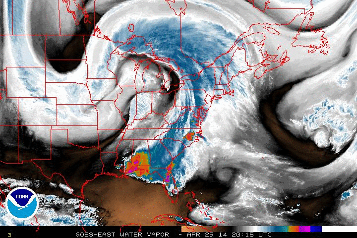
The overall storm system was monstrous. A strongly pronounced kink in the jet stream has been effectively stuck in place for days, held fast by a sluggish dome of high pressure over Hudson Bay in Canada. As I wrote earlier this week, blocking patterns like this are known for their ability to create extreme weather.
This is the same weather pattern responsible for a rash of tornadoes since Sunday and heavy snow in the Dakotas.
The result has been impressive, to say the least:
Looks like a screen cap from The Day After Tomorrow. #Anthropocene RT @capital_climate: pic.twitter.com/M2xuGXrFql
-- Miles Grant (@MilesGrant) April 29, 2014Here's a before/after of Blue Springs Ave by Crescent Lake in #Pensacola. Arrows denote same house. pic.twitter.com/3MnzxQYorI
-- Tim Ballisty (@IrishEagle) April 30, 2014Ono Island, Alabama. Shared by Local 15 NBC News Facebook page. pic.twitter.com/jf9AUldq0Z
-- Tim Ballisty (@IrishEagle) April 30, 2014If that last image looks like climate change to you, you’d be on the right track.
It probably wouldn't be correct to say that climate change caused Pensacola’s floods, but it surely made them more likely. Climate change is playing a role in extreme rainfall events like the one on Tuesday. The science is here is relatively straightforward: As the atmosphere warms, it can hold more water vapor. You can see this effect for yourself on muggy summer days when droplets of condensation form on the windows of air-conditioned buildings. There’s now more moisture available that can turn into rain. Warmer days lead to more evaporation, and more evaporation leads to heavier rainfall.
Essentially, we’re supercharging the atmosphere by quickening the hydrologic cycle. In addition to causing more downpours, these enhanced evaporation rates are also leading to an increase in drought severity in places that are already dry, like California.
In the context of these greenhouse gas–induced changes to the water cycle, the addition of an abnormally strong blocking pattern was the perfect recipe for Tuesday’s epic rains. A bizarre S-shaped storm system was responsible for funneling incredible amounts of moisture northward from the Gulf of Mexico.
In addition to rising global temperatures, the increasing frequency and intensity of extreme rainfall events is one of the clearest already observed effects of climate change. While these changes have been documented in many parts of the globe, it’s more certain that they’re happening in North America, in part because of better data here.
From the Environmental Protection Agency:
In recent years, a larger percentage of precipitation has come in the form of intense single-day events. Eight of the top 10 years for extreme one-day precipitation events have occurred since 1990.
The freshly released Intergovernmental Panel on Climate Change fifth assessment report found “high confidence” of a “likely” overall increase in extreme precipitation events in North America.

Courtesy of the EPA
Heavy rain and severe weather will continue to lash the East Coast on Wednesday, with flood watches and warnings currently in effect from Washington to New York City.
Update, 5:45 p.m.: The National Weather Service in Mobile has confirmed that Tuesday was the rainiest day since at least 1880 in Pensacola. Using a blend of rain gauges and nearby radar data, they estimate that 15.55 inches of rain fell during the 24-hour period. This total beat the old record, measured during a tropical storm, of 15.29 inches. (Return.)
Future Tense is a partnership of Slate, New America, and Arizona State University.