It’s increasingly certain that a major, multiday severe weather outbreak will take place across parts of the Midwest and South over the next few days.
The Storm Prediction Center—the tornado-forecasting arm of the National Weather Service—mentions a “favorable environment for long-lived supercells and multiple intense tornadoes” on Sunday across Missouri and Arkansas. The primary tornado threat will shift eastward and south in subsequent days, traveling through Tennessee, Mississippi, Alabama and Georgia, ending in the Carolinas and mid-Atlantic on Wednesday.
Even in places where tornadoes don’t end up forming, the slow progression of the overall weather pattern will result in many places seeing multiple rounds of thunderstorms and a widespread risk of flooding.
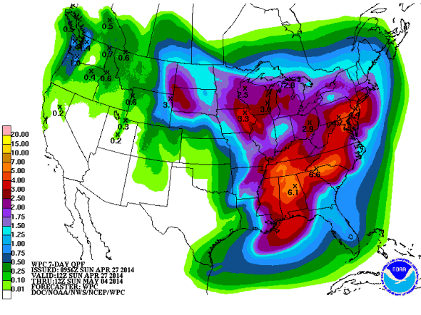
The National Weather Service office in Mobile, Ala., says that moisture available for storms over the coming days is about 200 percent of normal, making it likely to cause quick-hitting flood risks in places where successive rounds of thunderstorms track repeatedly over the same areas.
What makes this particular outbreak unusual is its longevity. An incredibly strong high-pressure center in Canada is helping to intensify and slow the progress of a swirling low-pressure center that’s sparking the heavy rain and severe weather. The overall pattern forms an “Omega Block,” known for its jet stream shape similar to the Greek letter. April and May is the time of year when Omega Blocks most frequently occur, coinciding with the typical start to tornado season. It’s the time of year with the greatest contrast in temperatures from north to south. Right on cue, an ice storm is imminent for Duluth, Minn., on Monday while temperatures in Texas could reach the upper 90s.
An emerging line of research ties intense blocking patterns such as this one to global warming, though the theory is still far from widespread acceptance. Such blocking patterns in recent years have tended to amplify weather patterns by elongating the jet stream, making extreme weather more likely.
Objective pattern-matching with historical weather data continues to identify some of the worst tornado outbreaks in the last few decades as analogs to the upcoming storms. That doesn’t necessarily mean the outbreak over the next few days will be equally historic, but it gives forecasters a clue that, in the past, weather patterns such as this have been incredibly dangerous.
Forecasters have noticed this. The SPC issued consecutive three-day outlooks for “moderate risk” of severe weather, anticipating Sunday and Monday’s threat. Though “moderate risk” might not sound terribly foreboding, this is only the second time such a confident forecast has been issued since 2000, when the SPC began issuing three-day severe weather outlooks.
Even as the parent storm system will be sluggish, individual supercells could be fast movers, potentially reducing the warning time available. If you live in the area, or know someone who does, be sure to enable the “Wireless Emergency Alerts” setting on your smartphone.
Here’s a timeline of what we can expect from this outbreak.
Sunday
Severe storms are already underway across Kansas and Oklahoma and will be shifting eastward throughout the afternoon and evening. The biggest tornado risk will be centered in northwest Missouri and central Arkansas. The National Weather Service in Kansas City is particularly concerned: “If there was any day to be weather aware, today should be that day.” The SPC mentions the available thunderstorm energy, corkscrew motion, and wind shear will combine to create “a very favorable environment for updraft rotation.” Storms may progress all the way from around Little Rock to the Memphis area during the late night hours.
Monday
According to the SPC, “an outbreak of severe storms including strong tornadoes and widespread damaging winds appears likely,” especially across Mississippi, northern Alabama, and western Tennessee, including Nashville. The day’s biggest tornado threat will come during the afternoon, when a messy cluster of supercells will form. The storms may evolve into more of a straight-line wind threat during the overnight hours, with the potential for gusts up to hurricane force.
Tuesday
The tornado threat continues for southern Mississippi and Alabama into Georgia. The National Weather Service office in Atlanta says Tuesday is “one of the best scenarios this spring for severe weather and heavy rainfall.” The severe weather risk is contingent upon afternoon sunshine, which will add energy to potential evening storms.
Wednesday
The last day in the severe weather outbreak is the most uncertain. It also could potentially affect the most people. Tornadoes could affect the Carolinas and eastern Virginia, up to around the Washington, D.C., area, should the pattern hold together as currently forecast. What’s more certain is the risk of extensive flooding from heavy rains across nearly the entire mid-Atlantic region, including Baltimore, Philadelphia, and New York City.
An additional disclaimer on the above analog maps: these are not forecasts. They’re a mosaic of actual past events that occurred when the atmosphere closely resembled the current forecast. For the latest actual forecast throughout the outbreak, stick to the National Weather Service.