Lake Mead Before and After the Epic Drought
A new study shows the Colorado River basin is losing water at a “shocking” rate.

Ethan Miller
A new study jointly released Thursday by NASA and the University of California at Irvine paints a shocking picture for the future of Western water.
Using a satellite designed to track changes in groundwater, the research team found that the Colorado River basin—which supplies water to 40 million people in seven states—lost 15.6 cubic miles of freshwater in the last 10 years. More than 75 percent of that loss came due to excessive groundwater pumping. It’s the first study to quantify just how big a role the overuse of groundwater plays in dwindling water resources out West. An accompanying map shows the striking impact of long-term drought in the fastest growing part of the United States. From Texas to California, the new research backs increasingly pressing efforts to limit groundwater pumping and renegotiate water rights in an era of global warming.
"We don't know exactly how much groundwater we have left, so we don't know when we're going to run out," said Stephanie Castle of UCI, the study's lead author, in a press release. "This is a lot of water to lose. We thought that the picture could be pretty bad, but this was shocking."
Nowhere is the drop in the Colorado River more apparent than in the Hoover Dam’s Lake Mead.
Earlier this month, Lake Mead set a new all-time record low. To memorialize the event, photographer Ethan Miller set out to take a series of “after” photos to complement pictures he took in July 2007. When you compare the two sets, the result is nothing short of stunning.
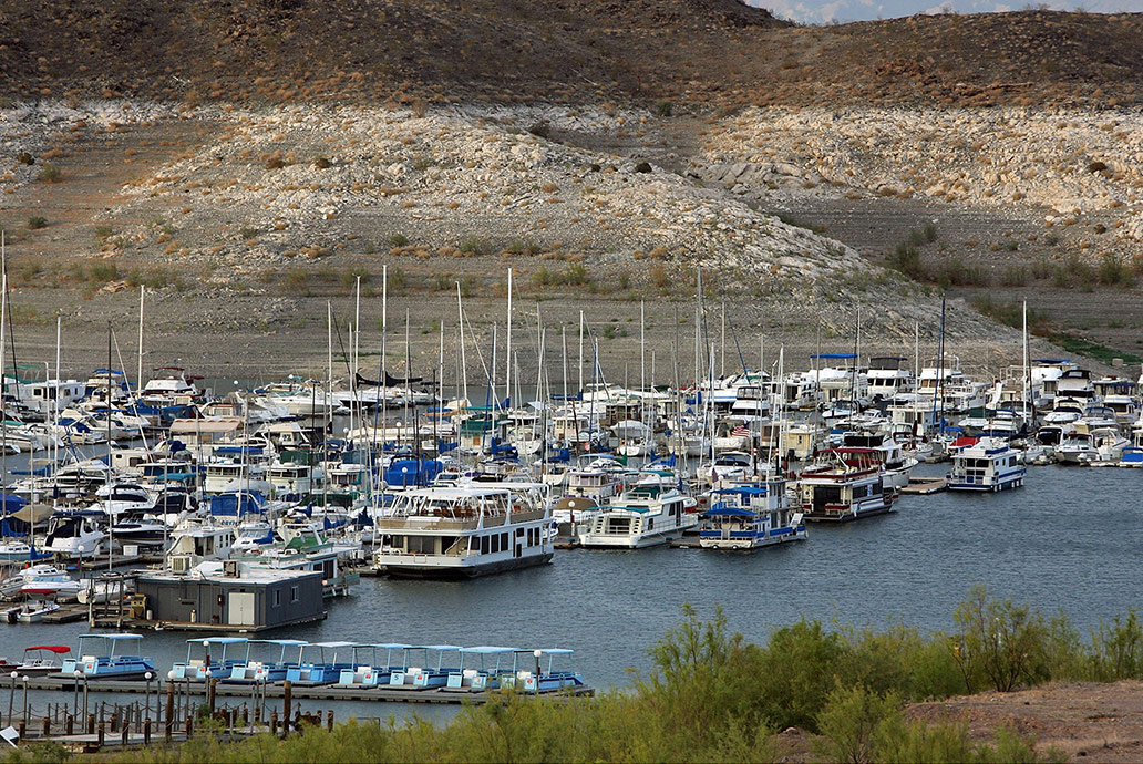
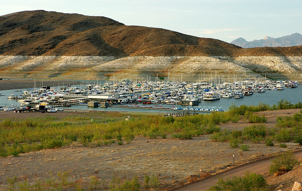
The Lake Mead Marina, in 2007 and 2014. The marina has been moved due to low water levels. Image: Ethan Miller/Getty Images
The massive body of water was created in 1936 after the construction of the Hoover Dam on the Colorado River. For decades, it was the largest manmade lake in the United States. No longer. (A lake that spans the Dakotas is now No. 1, thanks to the West’s long-term drought.) As people continue to flock to the Southwestern cities of Las Vegas, Phoenix, and Tucson, and as farmers keep watering the desert, Lake Mead continues to plummet.
This year, thanks to a wetland rehabilitation project in Mexico, the Colorado briefly reached the Sea of Cortez again for the first time since the El Niño floods of 1998. Before humans started tampering with building massive dams on the Colorado, it did so every year.
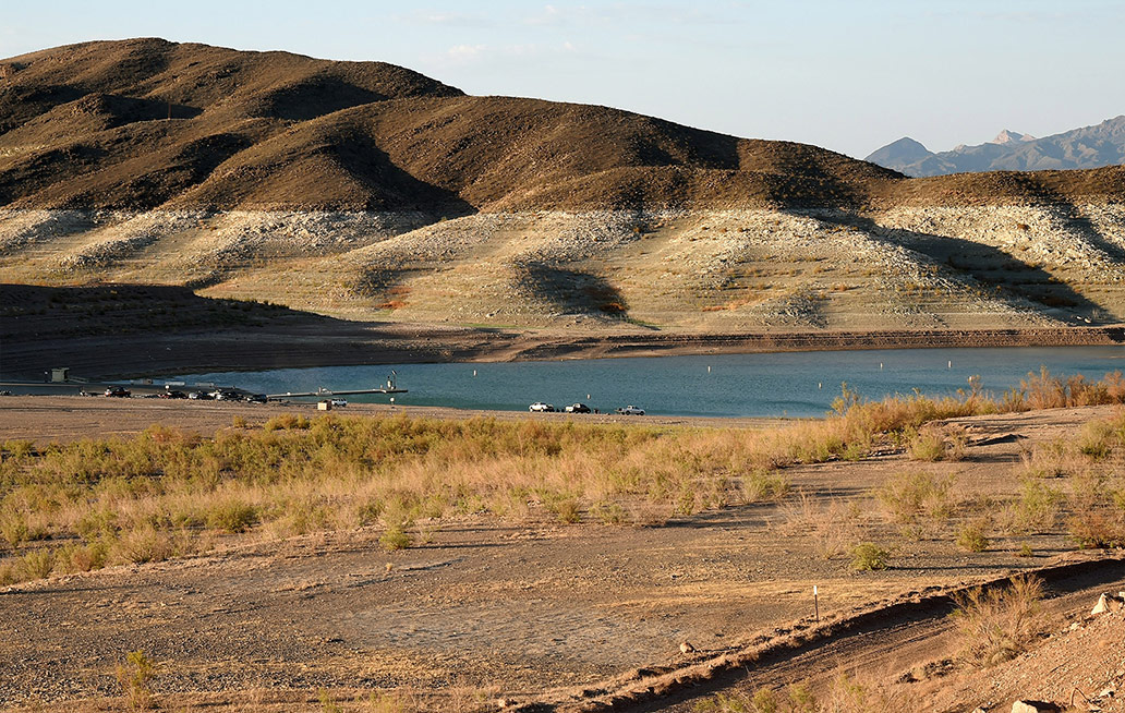
A pair of restrooms on pontoon boats now sits on dirt in this 2007/2014 before-and-after of Lake Mead Marina. Image: Ethan Miller/Getty Images
In the last seven years, Lake Mead’s dwindling has accelerated. The lake is now just barely more than 1,080 feet above sea level, slightly below its previous record low set in November 2010.
The before images were taken when the lake level was 1,111 feet above sea level. Lake Mead hasn’t been officially full—1,221 feet above sea level—since 1983.
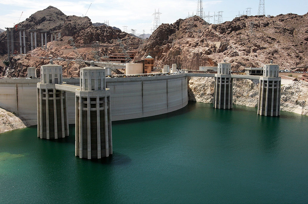
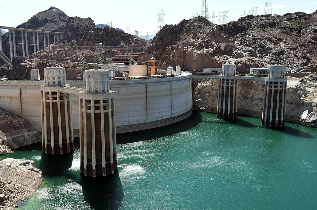
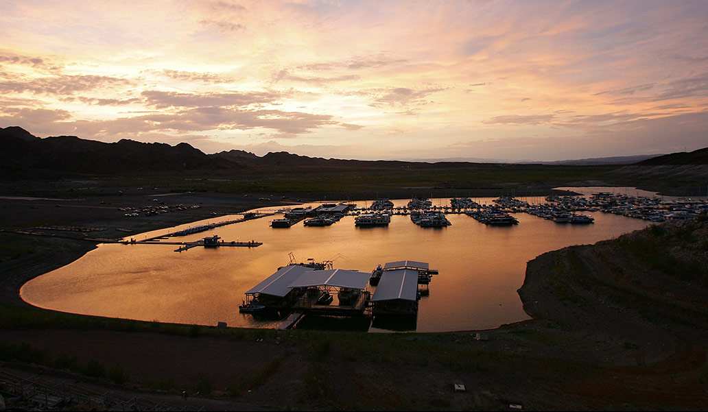
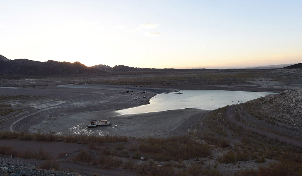
The massive intake towers on the Hoover Dam in Lake Mead straddle the Nevada/Arizona border, in this 2007/2014 before-and-after. Should the current drought continue, the Hoover Dam could lose the ability to generate electricity. Image: Ethan Miller/Getty Images
Thanks to an ongoing mega-drought, Lake Mead’s water level will continue to fall for the indefinite future. Thursday’s joint NASA–UCI study implicates continued groundwater pumping in the rapid decline.
In a two-year forecast (PDF) released earlier this month by the U.S. Bureau of Reclamation, which manages Lake Mead, the lake is expected to drop another 20 feet into record territory by summer 2016. Well before then, perhaps as soon as next April, downstream water rationing will kick in—which has never happened before.
The scenarios only get worse from there. According to a New York Times interview with John Entsminger of the Southern Nevada Water Authority, “If Lake Mead goes below elevation 1,000, we lose any capacity to pump water to serve the municipal needs of seven in 10 people in the state of Nevada.” City of Las Vegas, consider this your official warning.
Lake Mead Marina is one casualty of a dwindling Colorado River. Image: Ethan Miller/Getty Images
As shocking as images of the desiccating lake are, Las Vegas is in no immediate danger of running out of water. As long as the new “third straw” intake—a more than $800 million project designed to drought-proof Las Vegas’ water supply—is completed in time, which will allow the city to suck water from Lake Mead down to the very last drop. In the meantime, Las Vegas and other Western cities have been storing treated Colorado River water in underground aquifers in preparation for eventual shortages. Las Vegas has banked about 18 months’ worth of supply in this manner. Despite the city’s wasteful ways and nearly complete dependence on Lake Mead and the Colorado River, Las Vegas takes only a small fraction of the river’s total flow each year.
The bigger problem is, global warming is starting to tip the odds toward more frequent and severe drought in the Southwest, and the future doesn’t look too bright. That means that in just 20 years, Lake Mead could reach so-called “dead pool” levels—an unusable state in which the Hoover Dam, that symbolic marvel of 20th-century triumph of human ingenuity over nature would become obsolete, likely for good.
One NASA scientist and co-author of Thursday’s study, Jay Famiglietti, said in a press release that the new research on overuse of groundwater could be the nail in the coffin for water out West. "Combined with declining snowpack and population growth, this will likely threaten the long-term ability of the basin to meet its water allocation commitments to the seven basin states and to Mexico."

Ethan Miller
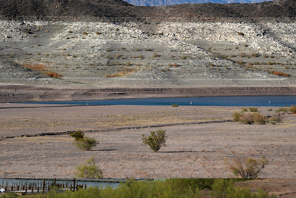
In the seven years between these images, desert shrubs have reclaimed part of what was once Lake Mead. Image: Ethan Miller/Getty Images
Update, July 25, 2014: This image originally appeared with a slider. It has been replaced with a side-by-side comparison of the images to provide a more accurate depiction.
This article is part of Future Tense, a collaboration among Arizona State University, the New America Foundation, and Slate. Future Tense explores the ways emerging technologies affect society, policy, and culture. To read more, visit the Future Tense blog and the Future Tense home page. You can also follow us on Twitter.