High Risk of East Coast Tropical Development This Week

What may become the first tropical system of the 2014 Atlantic hurricane season has begun brewing off the Carolina coast, and weather models show it may affect much of the East Coast for the July 4th holiday weekend.
In its 2 p.m. Sunday update, the National Hurricane Center—America’s tropical tempest nightwatchmen (and women)—said there is an 80 percent chance that the swirling mass of clouds will develop into a full-fledged tropical cyclone within the next five days.
Regardless of whether it meets official criteria of a tropical cyclone (a well-defined surface circulation and intense thunderstorm activity), wet weather is becoming increasingly likely along the East Coast later this week. If the disturbance reaches tropical storm strength (sustained winds greater than 39 mph), it will be given the name Arthur.
Here’s what the storm looks like right now:
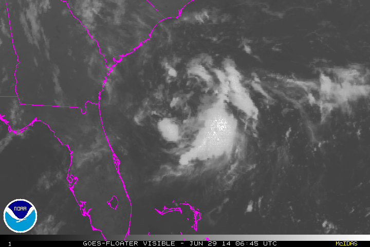
In the above GIF loop courtesy of NOAA, the system that may grow into Tropical Storm Arthur has already developed a noticeable circulation. (The sweeping transition midway through was Sunday morning’s sunrise.)
Assuming the developing system survives (which is not guaranteed), there are still a lot of uncertainties regarding who gets hit and how hard.
In the best-case scenario, the storm will dawdle off the coast of Florida for the first half of the week before it feels the pull of a late-week cold front, remaining offshore as it tracks northward by next weekend. The Euro model—generally considered the most accurate when it comes to tropical storm forecasting—stalls the system just offshore Florida for the next two or three days before brushing the Outer Banks of North Carolina on July 4th as a strong tropical storm. The current GFS model is in general agreement, showing the storm system dipping a bit farther south into Florida and never quite strengthening too much.
In the current worst-case scenario, a strong tropical storm will rake the entire East Coast. Yesterday’s Euro showed just such a scenario, with future Tropical Storm Arthur tracking from South Carolina to Staten Island on a four-day tour from July 3 through 7.
In both cases, rain looks increasingly likely from the Carolinas to New England on the Fourth of July—it’s just a matter of whether it’s an afternoon sprinkle or a torrential downpour accompanied by winds strong enough to send your barbeque grills skyward.
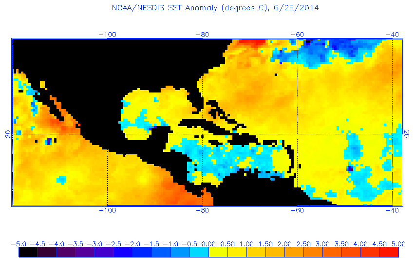
One feather in the hat for future Arthur is the abnormally warm ocean temperatures it’s currently camping over, near the Gulf Stream:

Image: NOAA
One other wildcard: Though an El Niño hasn’t yet been officially declared by NOAA, weak El Niño-like conditions are already occurring in the tropical Pacific Ocean. El Niño typically works against tropical cyclone formation in the Atlantic by increasing the speed of upper level winds, which can shred apart developing circulations like this one.
With the first storm of the season potentially forming so close to shore, there may not be much lead time for those immediately in line for its impacts. The National Hurricane Center has announced the future possibility of issuing forecast model-based warnings in advance of official storm formation (PDF), but current procedures forbid this.
A U.S. Air Force hurricane hunter aircraft is scheduled to investigate the storm around sunrise on Monday morning to directly measure the low-level wind speed and direction in an attempt to determine if the well-defined circulation has made it to the surface. If it has, and if the currently sparse thunderstorm activity increases, the National Hurricane Center will start issuing official forecasts. A hurricane hunter mission tentatively scheduled for Sunday afternoon was canceled, likely due to the relatively low number of thundershowers incorporated into the system so far.
Future Tense is a partnership of Slate, New America, and Arizona State University.