[Note: At the bottom of this post is a gallery of astonishing pictures of volcanoes taken from space.]
Note to self: visit Tahiti someday.
Phil Plait writes Slate’s Bad Astronomy blog and is an astronomer, public speaker, science evangelizer, and author of Death From the Skies!
[Click to breathtakenate, and yeah, trust me here, do it.]
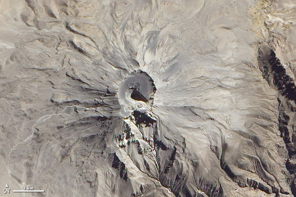
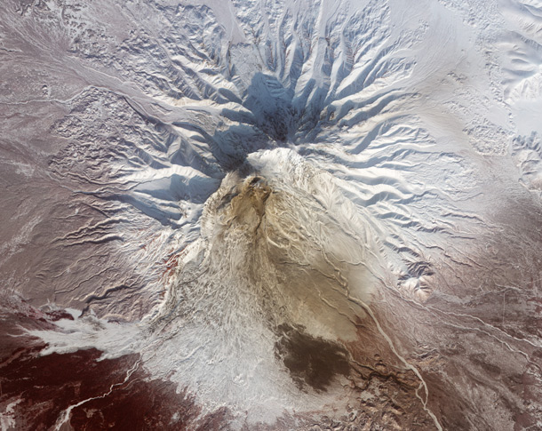
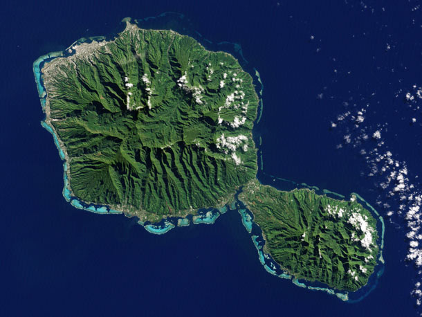
This image of Tahiti was taken by Landsat 7 back in 2001. We may think of Tahiti as a tropical paradise -- because it is -- but like so many other islands in French Polynesia it's actually a volcano. In fact, its two: Tahiti Nui, the bigger one to the northwest, and Tahiti-Iti to the southeast. Both are shield volcanoes, built up from lava flows. Nui is older, with hardened lava flows ranging from 300,000 to 1.7 million years old, while Iti is somewhat younger, only a mere 300,000 - 900,000 years old. Both volcanoes have had events where the shield has collapsed, so there are no classic circular holes in their middles.
Not only that, but their appearance has been heavily modified over the millennia by rainfall and erosion. Those deep crevices are where water has flowed down and eaten away at the slopes, and the color is of course from vegetation that thrives there. All of this makes the pair less volcano-looking and more oh-my-god-I-want-to-visit-there-looking.
See that little triangular jut-out of land at the very top of Tahiti-Nui? That's called point Venus, and is where Captain Cook landed to observe the 1769 transit of Venus (you should read that link; it's a cool story). It took them nearly a year to sail from England to Tahiti. Not too many scientific expeditions these days take that long to reach their destinations... with the notable exception, of course, of planetary probes, which can take much longer than that to reach their own Point Venus.
I've been to three volcanoes in my life -- Taburiente on the island of La Palma, Pululahua in Ecuador, and Crater Lake in Oregon (one of the most astonishing places I have ever been). They are magnificent, transcendent places, and one day, I think, I'll find a way to visit this pair of craggy, warm, and fantastically beautiful volcanoes so far away.
NASA Earth Observatory image by Jesse Allen and Robert Simmon, using Landsat data from the U.S. Geological Survey.
Bad Astronomy Gallery
(click any image to see it full size)
Volcanoes From Space Part 2
Volcanoes are among the most magnificent geologic structures on Earth, but sometimes the best view is from above Earth. This gallery features beautiful and fascinating images of volcanoes and eruptions taken from satellites orbiting our planet. It's actually the second such gallery I made; here is the first one (scroll to the bottom to see it). Click the images to see bigger versions and/or get more information about them.
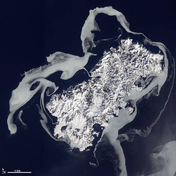
Fire and Ice
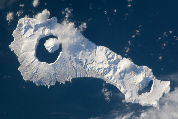
Onekotan island is a 50-kilometer-long volcanic double caldera in the Russian federation, in the western Pacific. A caldera is a depression that form when a magma chamber under the volcano collapses, creating the crater. The huge caldera on the left, called Tao-Rusyr, has filled with water since its collapse, and a new volcano - krenitzyn -- is now building up once again. This picture, taken in January 2011 by an astroanut on the International Space Station, is a study in contrasts. The frigid snow covering the volcanic island belies the terrible power and heat below.
Original image
Blog Post
Credit: NASA
Verdant volcano in a silvery sea
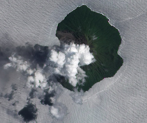
I love this shot of the south Pacific Tinakula volcano as seen by the Earth Observing-1 satellite. Tinakula is only sporadically active, and EO-1 caught a plume of steam and some ash from a mild eruption from February 2012.
But it's the water that makes this image so odd and lovely. It's actually natural color; the sunlight is glinting off the water, giving it that silver sheen.
Original image
Blog post
Image credit: NASA/Jesse Allen and Robert Simmon (Earth Observatory)
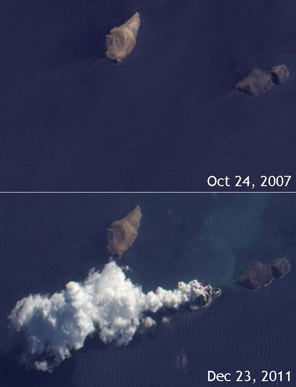
A New Volcano Parts the Red Sea
Off the coast of Yemen, in the Red Sea, are a chain of islands called the Zubair Group. Two of them, Haycock (left) and Rugged (right) are about a kilometer long. Things were pretty quiet there until December 2011, when suddenly a new volcano erupted from the water!
Holy wow! I had no idea that area was volcanic, but it turns out it's a rift zone, where tow continental plates are separating. Earthquakes are relatively common, and then of course entirely new volcanoes sometimes pop up, too.
Now there's a way to part the Red Sea.
Original Image
Blog post
Image credit: NASA Earth Observatory/Jesse Allen, using EO-1 ALI data provided courtesy of the NASA EO-1 team.
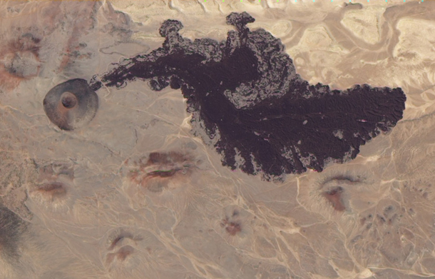
Go with the (new) flow
Bagana volcano is in a very remote part of Papua New Gunea. Located far from towns and cities. While it may hide from human eyes, it can't from our robotic ones: the Earth-Observing-1 satellite caught Bagana erupting in May 2012. The dark brown lava flow to the upper right occurred sometime after March 2011. It's so new there hasn't been time for vegetation to grow on it, even in that tropical climate. The volcano is very active; you can see several older flows that are tinged grren with plant life. Satellites are critical for observing and understanding volcanic activity, especially in hard-to-reach locations.
Original image
Blog post
Image credit: NASA/Jesse Allen and Robert Simmon using EO-1 ALI data
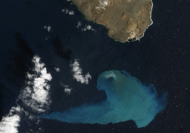
Volcano in Teal
The Canary Islands are a volcanic chain off the coast of Morocco, and geologically are very much like the Hawaiian islands. They're still active, too: a new volcano is being born even as we watch! Off the westernmost tip of the chain, an as-yet unnamed volcano has been erupting since October 2011. As of March 2012, the peak is still more than 100 meters below the surface of the ocean, but it's growing. By 2014 or so we may have to add a new island to the map of the Canaries.
Original image
Blog post
Image credit: NASA Earth Observatory/Jesse Allen and Robert Simmon, using EO-1 ALI data
The icy swirls of Ostrov Shikotan
Off the eastern coast of Russia and north of Japan is an amazingly long 1300-km volcanic archipelago called the Kuril Chain. The weirdly rectangular Ostrov Shikotan is at the southern end, and has two extinct volcanoes on it. Tken in February 2011 by the Earth Observing-1 satellite, this photo shows icy water blown by opposing winds swirling around the island.
I love pictures of volcanoes from space, but this one is among my very favorites.
Original image
Blog post
Image credit: NASA/Jesse Allen and Robert Simmon, using EO- ALI data provided courtesy of the NASA EO-1 team
Double your volcanic paradise
Tahiti is known as a tropical paradise for good reason, but the island is actually made of two volcanoes connected by a narrow and short isthmus. The larger one, Tahiti-Nui, is older, with lava rocks dated to 1.7 million years ago. Tahiti-Iti, the smaller one, has lava less than a million years old.
Both shield volcanoes have collapsed, and heavy erosion from rainfall has radically changed their appearance from all that time ago when they formed. This Landsat 7 image makes all that very clear... though I imagine from ground level it's far, far tougher to see.
Original image
Credit: NASA Earth Observatory image by Jesse Allen and Robert Simmon, using Landsat data from the U.S. Geological Survey.
Angling in on the edge of the abyss
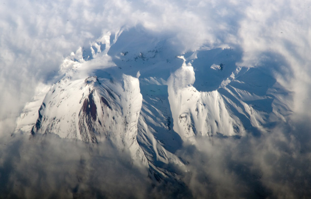
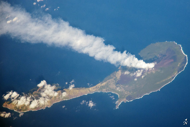
Some of my favorite shots of volcanoes from space are not from satellites, but from the International Space Station astronauts. Most satellites look straight down, but astronauts suffer from no such limitation. This view of the Pagan volcano in the Marianas islands was taken in March 2012, when ISS was hundreds of kilometers south of the volcano. The narrow island actually has two volcanoes; one at each end separated by that isthmus. This area is where the Pcific plate is subducting under (going beneath) the Phillippine plate, which causes a lot of volcanic activity. It's also, not coincidentally, the location of the Mariana Trench, the deepest point in the Earth's crust.
Original image
Blog post
Image credit: NASA
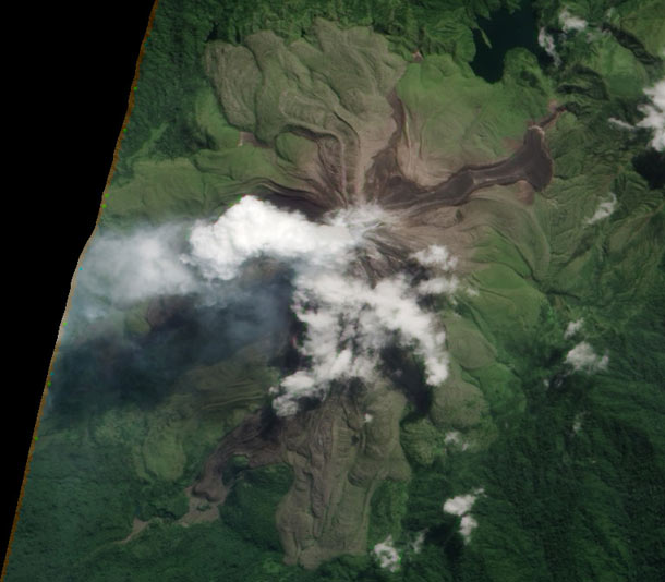
Water and ash
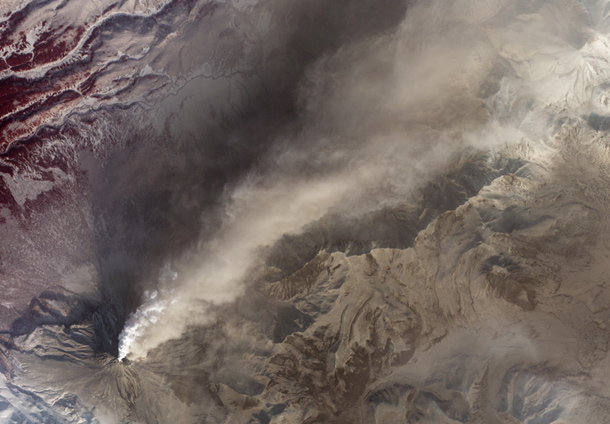
The Kamchatka peninsula is familiar to anyone who played the game Risk as much as I did as a kid: it's at the extreme northeast end of the Asian continent. It's also the home of many volcanoes, including Kizimen, which which has been erupting more or less continuously since December of 2010 -- after eight decades of rest.
The plume is white and tan, meaning it has water vapor in it as well as ash, and fresh ash falls line the flanks. These may also be from pyroclastic flows - torrential waves of burning hot ash which plow down the slopes at hundreds of kilometers per hour.
Original image
NASA Earth Observatory image by Robert Simmon, using data from the NASA/GSFC/METI/ERSDAC/JAROS, and U.S./Japan ASTER Science Team.