Weather satellites capture shots of volcanic plume blasting through clouds
[Note: at the bottom of this post is a gallery of volcano pictures taken from space.]
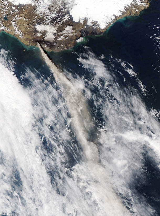
Just in case you forgot that the Earth is one of the most geologically active worlds in the solar system*, the Icelandic volcano Grimsvötn has sent a very loud reminder: after seven years of relative inactivity, the volcano woke up on Saturday, rocketing a plume 11 kilometers (7 miles) into the air. The ash column blasted through the cloud layer, and was seen by weather satellites in space! Check out this amazing animation:

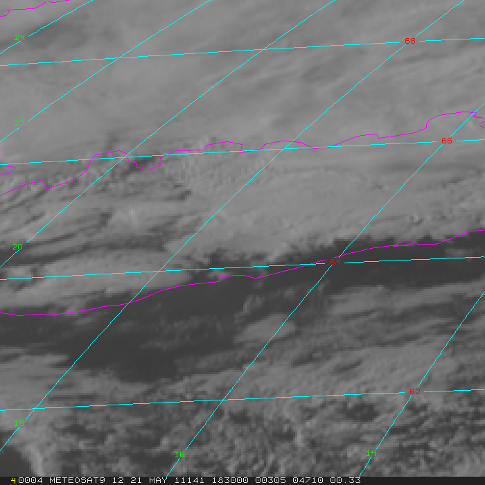
That was the view from the Meteosat-9, a European satellite in geostationary orbit. The animation is composed of visible light images and covers just under a three hour time span on May 21. You can clearly see the plume breaching the cloud layer and spreading out, then a second plume blowing through shortly thereafter. The shadow of the plume on the clouds gives an excellent but eerie sense of the scale of this event.
Here's a similar view from the US GOES 13 satellite showing 3.5 hours of the eruption:

Note the oblique angle and distance; GOES 13 orbits the Earth far west of the volcano. In the last frame of the animation you can see the outline of Iceland to give you an idea of the size of this event.
This volcano has erupted many times over the past few decades. I knew Iceland was active, but what really brought it home to me in this case was a quote by a company that operates the airport facilities in Iceland, when a 220 km no-fly zone around the volcano was established: it was described as "standard procedure around eruptions".
Yikes. The fact that they even need a "standard procedure" is eyebrow-raising to me; where I live, volcanoes are somewhat rare (maybe more so now than a millennia ago). However, this eruption doesn't currently look like it will be a big danger to air travel like last year's eruption of Eyjafjalajökull was; the ash is made of bigger particles which fall to the ground more quickly, and the volcano itself is located in a relatively isolated part of southeast Iceland.
Still, clearly, researching volcanoes and their eruptions is critical to many areas of life. Besides the knowledge added to our basic scientific understanding of geology and the Earth, monitoring and understanding volcanoes has a huge impact on air traffic, weather, and the daily lives of millions of people.
Image credits: CIMSS, UW-Madison (from images by EUMETSAT and NOAA). Tip o' the caldera to Jonatan Gislason.
I love these satellite views of volcanoes from space, and I've collected quite a few into a gallery slideshow. Click the thumbnail picture to get a bigger picture and more information, and scroll through the gallery using the left and right arrows.]
* Jupiter's moon Io actually beats us in that category.
Bad Astronomy Gallery
(click any image to see it full size)
In this image taken by NASA's Earth Observing-1 satellite, taken on January 6, 2011, you can see a long plume of ash and water vapor stretching to the east. The volcano has been rather gently erupting since New Year's Eve, so observations like this one are important in understanding the extent and nature of the activity.
I love the look and feel of this image; the terrain there is incredibly hostile, mountainous and remote. That's accentuated by the sunlight casting shadows across the region. This image was captured in mid-morning, just a few hours after local sunrise - you can tell by the shadows pointing north and west, so the Sun must have been south and east when this was snapped.
That whole area is lousy with incredible volcanoes... scan through this gallery and you'll see plenty more.
Image credit: NASA
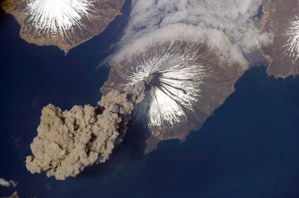
Image credit: NASA
Just outside the field of view of this picture is the city of Yogyakarta, which has a population of 400,000. As you can imagine, satellite tracking of volcanoes like this are critical when major population centers lie so close to them.
Image credit: NASA/GSFC/METI/ERSDAC/JAROS, and the U.S./Japan ASTER Science Team
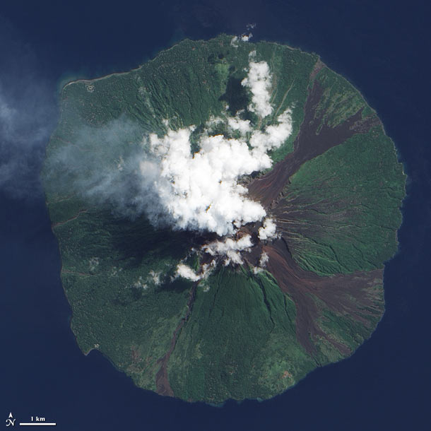
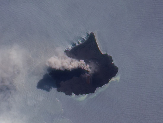
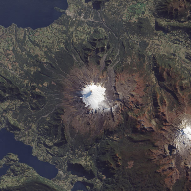
This is one of my favorite pictures of volcanoes from space, because it's almost seen straight down, the island is so nearly symmetric, and the plume so well-centered. It's exactly how I imagine these things should look from orbit!
Image credit: NASA
This image, taken by NASA's Aqua satellite in May 2010, shows the plume reaching south toward England.
Image credit: NASA
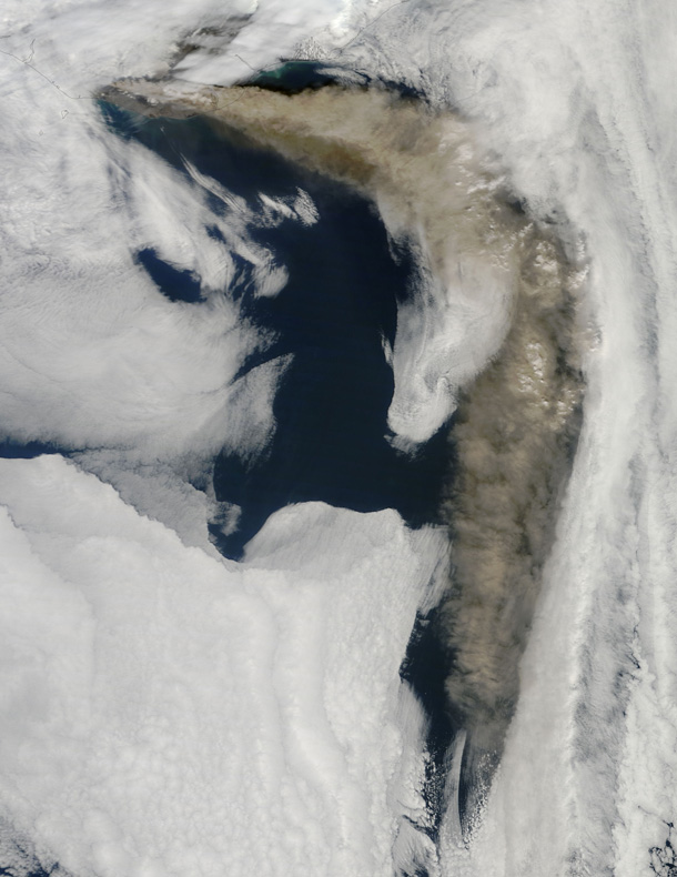
Image credit: NASA
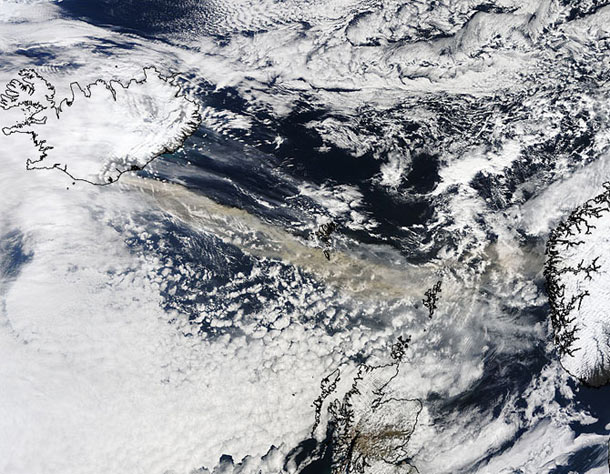
Image credit: NASA
Over the past century, the volcano has been building itself back up, as you can see in this picture taken by the Earth Observing-1 satellite. It's over 2 km (1.2 miles) across now. It may be decades or centuries before another catastrophic eruption occurs, and in the meantime NASA keeps an eye on this sleeping giant.
Image credit: Jesse Allen/NASA EO-1 team
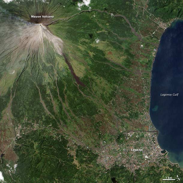
Mayon has a history of violence - in December 2009 and January 2010, just after this image was taken, it had a series of minor ash eruptions - and has been the cause of many, many deaths. Scientists studying volcanoes like Mayon learn how to predict their eruptions, and can save countless lives... just in case you were wondering what science has ever done to help people.
Image credit: NASA
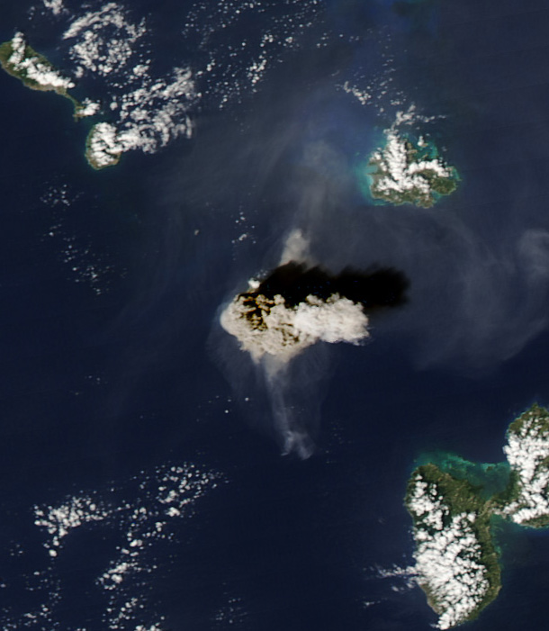
NASA's Aqua satellite caught the collapse and subsequent eruption in this incredible picture. You can see the shadow of plume, and get a feel for the scale of this event.
The 1997 eruption of Soufriere killed 19 people on an island of 4000... showing that scientists predicting eruptions do in fact save many, many lives.
Image credit: NASA
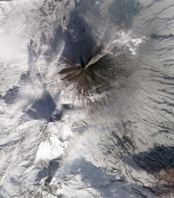
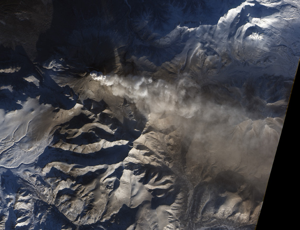
Klyuchevskaya erupts calmly and steadily, releasing the pressure underneath it continuously, instead of in a more dramatic explosion. That whole region is lousy with craggy mountains and volcanoes; click the link to get access to a huge version of this image and get an overview of this forbidding landscape.
Image credit: NASA
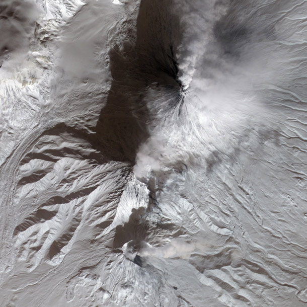
Image credit: NASA
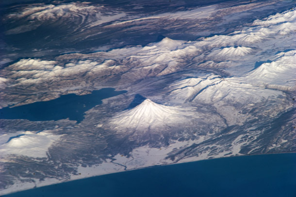
In this stunning shot (taken on November 19, 2010) the volcanoes of eastern Kamchatka, Russia, are seen to the northwest from a distance of about 1000 km (600 miles). You can even see the shadows of the volcanoes from the morning Sun.
Many of these volcanoes erupted in the 20th century, though for some it's been a few centuries since they were active. The large body of water is Lake Kronotsky, formed when lava from the Kronotsky volcano (the large symmetric cone in the center) dammed a river.
Image credit: NASA
The detector on the camera is a single row of pixels. As the satellite moves around the Earth, the detector sweeps over the landscape, and the one-dimensional row of pixels can be stacked up to create a continuous picture of what's going on below. It's just one more way scientists can observe our home planet and learn how it behaves. Sometimes learning about Earth isn't obvious, and stepping away - and using unusual methods - is the best way to do it.
Image credit: NASA
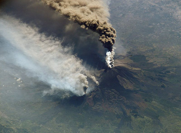
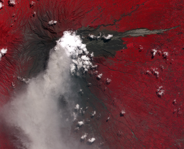
In 2002, Etna erupted in a relatively large display of lava and ash. This view was taken by Expedition 5 about the International Space Station, looking southeast at a low angle. This eruption let loose a river of lava down the flank of the volcano which set fire to pine trees there; the dark plume is from the eruption, but the whiter ones are from burning pine trees. The plume from this eruption blew south and was reported as far away as Libya, nearly 600 km distant.
Unlike Earth observing satellites, which point straight down, astronauts on the ISS have the luxury of seeing things at an angle, providing a more natural - and in this case, more spectacular - view to our human eyes and brain.
Image credit: NASA
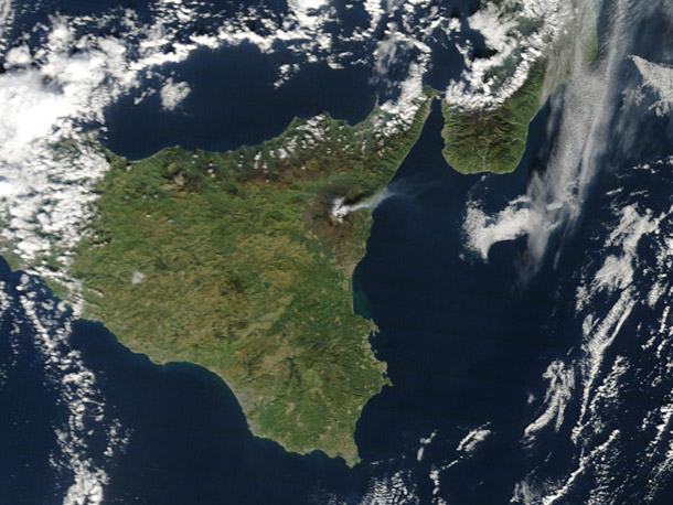
Don't be fooled. The plume shut down a nearby airport (volcanic ash is composed of very spiky and sharp-edged glass and silicates which can be dangerous to breathe and can damage plane engines in flight) and causes many other snarls in the lives of Sicilians.
Image credit: MODIS Rapid Response Team, NASA/Goddard Space Flight Center
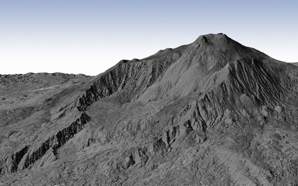
By precisely measuring the time it takes the pulses to hit the ground and reflect back, a map of the topography of the region can be assembled. This can then be used to make a model of the volcano in three dimensions, which can be viewed from any angle, even one mimicking the view from the ground.
Emily Lakdawalla at The Planetary Society Blog has the details on this amazing image, as well as a much larger version.
Image credit: DLR