No, New York City Will Not Get 30 Inches of Snow This Weekend

Photo by Stan Honda/AFP/Getty Images
Within the past 36 hours, a vicious rumor has gone viral that an epic blizzard is heading for New York City this weekend.
It’s not true. We’re not going to be buried up to our eyeballs in snow, the Stay Puft man will remain safely locked away in his marshmallow-y cave, and there’s no blizzard-creating government secret-weapon testing planned.
How'd this rumor start?
Somehow, probably on Monday, somebody reposted a link to this Gawker article from last February that tried to portray the weather hysteria still fresh on the minds of New Yorkers a few months after Superstorm Sandy. At that point, all hell broke loose. Split between this year and last, the article has gathered more than 800,000 views, according to my last check of Gawker’s public page-view counter.
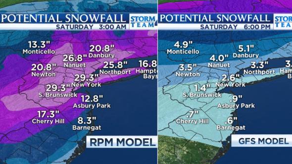
Embedded was this provocative graphic, which originated on a Facebook post made by a local television station a year ago:

Courtesy of StormTeam4NY/Facebook
Gawker itself inadvertently added fuel to the fire Tuesday morning by reposting the old link it saw was trending. Whoops.
Gawker staff explained as much in a series of tweets:
@EricHolthaus @Gawker It had started trending (on Facebook?) for at least a day before it was (accidentally) added to the link roundup
-- max read (@max_read) February 5, 2014@EricHolthaus @Gawker actually it was going around earlier b/c someone misread the date and it got shared around.
-- John Cook (@johnjcook) February 5, 2014@EricHolthaus @Gawker and b/c it had become one of our most popular posts from that, it accidentally got added to a link round-up
-- John Cook (@johnjcook) February 5, 2014It’s gone viral again, this time perhaps due to some combination of similar rumors last week, the one-two-three punch of actual winter weather currently in the area, and some people’s inability to read a date.
Since Tuesday afternoon, I’ve gradually ratcheted up my debunkometer on Twitter:
There will *not* be 30" of snow in NYC this weekend.
-- Eric Holthaus (@EricHolthaus) February 4, 2014yes. RT @conz: @EricHolthaus pinky promise?
-- Eric Holthaus (@EricHolthaus) February 4, 2014I repeat: there will not be 30" of snow in NYC this weekend.
Eric Holthaus (@EricHolthaus) February 5, 2014@AreolaHead it's way too early for a snow total forecast. The storm (if there is one) is 5 days away.
-- Eric Holthaus (@EricHolthaus) February 5, 2014Once again, there will NOT be 30" of snow in NYC this weekend. This rumor needs to die a painful death now. cc @Brian_Villanova
-- Eric Holthaus (@EricHolthaus) February 5, 2014.@paulythegun I'd never write again (and give each of my followers $1000) if NYC gets 30" this weekend.
Eric Holthaus (@EricHolthaus) February 5, 2014@anthonyspanti @Brian_Villanova single storm snowfall record for central park is 26.9". simply not possible to forecast 30" of snow in NYC
-- Eric Holthaus (@EricHolthaus) February 5, 2014So what kind of weather can New York City actually expect this weekend?
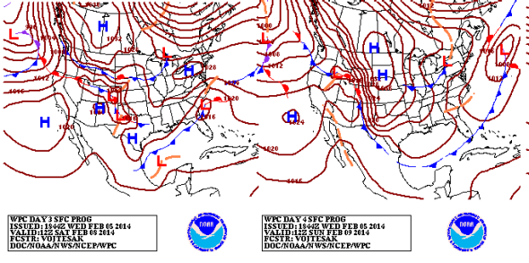
The latest from the National Weather Service does in fact show a coastal storm brewing for the weekend, but forecasts during the past few days have been hinting the bulk of the storm will remain offshore, reducing the risk of big snows.

Courtesy of NOAA’s Weather Prediction Center
As of now, it looks like snow is possible—inches, not feet—but it’s still much too early to nail down a specific forecast range. Accurate forecasts of snow totals really only have measurable skill within about 72 hours of the first flakes.
This afternoon’s forecaster discussion from National Weather Service local office in the NYC area mentions the storm in cautious terms:
For the upcoming weekend...model solutions diverge due to the progressive flow...and several pieces of energy...timing and positional differences...leading toward the different solutions.
In general...expect dry conditions early Saturday...then there is a chance...low chance...that the area will get brushed with some light snow as an area of low pressure develops well to the south and passes south of the 40/70 benchmark.
The 40 degrees north latitude and 70 degrees west longitude map coordinate offshore of Long Island is a shortcut meteorologists use to gauge potential impact of winter storms passing near New York City. If the storm’s center passes too far south of that point, most of the snow will stay offshore. If the center passes north of that point, the storm usually has a hard time drawing enough energy from the relatively warmer ocean waters, cold air can’t mix effectively into the circulation, and New York City typically ends up with yucky cold rain.
So, yes, we’ll still need to keep an eye on upcoming snow chances, especially as the region digs out of the actual snow and ice that are currently plaguing us.
Future Tense is a partnership of Slate, New America, and Arizona State University.
