Dating an active volcano. And I don't mean metaphorically.
[Note: At the bottom of this post is a gallery with more awesome pictures of volcanoes from space!]
One of the best uses of space exploration is to look back on our own planet. So much of our Earth -- as heavily explored as it is -- is so far from human eyes that the best view is from hundreds of kilometers above.

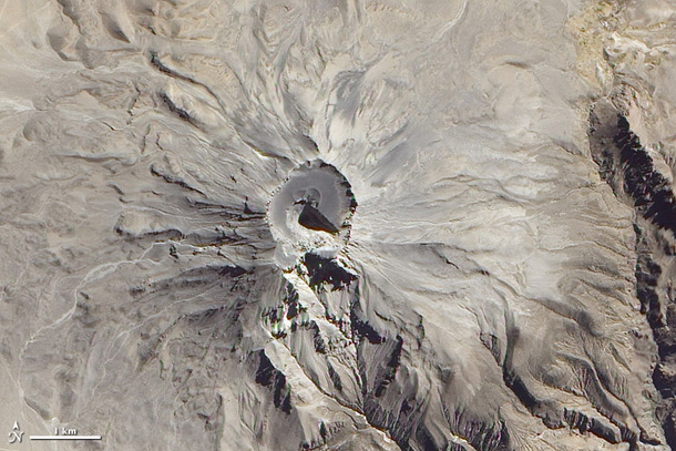
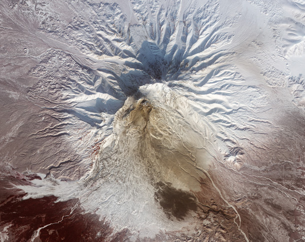
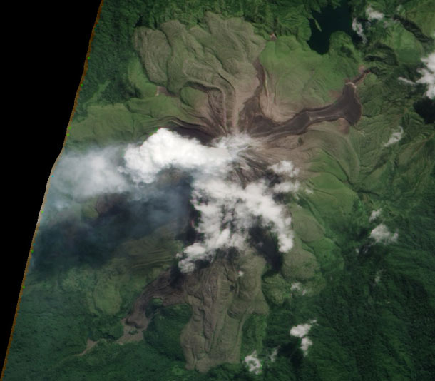
This is certainly true in the case of the volcano Bagana, located in Papua New Guinea. Although the top of the stratovolcano reaches nearly 1800 meters high (more than a mile), it's so far from any population centers that it's difficult to monitor. But the Earth Observing-1 satellite doesn't care how far humans are, and its view is of the volcano is unparalleled.

[Click to hugely encalderenate.]
This natural-color shot, taken on May 16, 2012, is very revealing. The big tongue of lava flowing up and to the right is new; it wasn't there before March of 2011. You can tell it's new by looking at the color: brown, the color of fresh rock. Papua new Guinea is tropical, and bare ground doesn't last long. If you look at other flows around that volcano, you can almost guess which ones are older by how much greener they are. In fact, relative ages of flows sometimes can be found that way.
You can also see the thick plume of water vapor and gas blowing to the left (west), and scattered clouds over the volcano. The detail on this image is remarkable; the north-south extent of the new flow at the tip (where it spreads out vertically in the picture) is only about 600 meters (2000 feet)! You could fairly easily hike across it in less than an hour... assuming the terrain isn't rugged. I'm guessing it is; Bagana is known for thick lava flows, and that generally produces aa -- the solidified lava that's rough-hewn and has rocks full of sharp edges. Those are sometimes called clinkers. I was on the La Palma volcano years ago, and the pumice rocks there would make high-pitched clinking sounds when they hit each other. The reason for the name was pretty obvious.
Image credit: NASA/Jesse Allen and Robert Simmon using EO-1 ALI data
Related Posts:
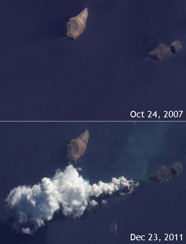
- Desktop Project Part 20: Angling in on a smoking volcano
- Desktop Project Part 11: Upside down volcano plume
- Desktop Project Part 7: A new volcano parts the Red Sea. Kinda.
- Desktop Project Part 4: Underwater volcano in teal
Bad Astronomy Gallery
(click any image to see it full size)
Original image
Blog Post
Credit: NASA
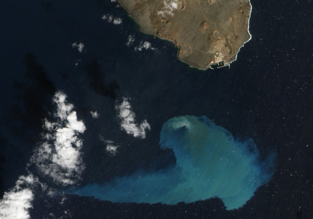
But it's the water that makes this image so odd and lovely. It's actually natural color; the sunlight is glinting off the water, giving it that silver sheen.
Original image
Blog post
Image credit: NASA/Jesse Allen and Robert Simmon (Earth Observatory)
Holy wow! I had no idea that area was volcanic, but it turns out it's a rift zone, where tow continental plates are separating. Earthquakes are relatively common, and then of course entirely new volcanoes sometimes pop up, too.
Now there's a way to part the Red Sea.
Original Image
Blog post
Image credit: NASA Earth Observatory/Jesse Allen, using EO-1 ALI data provided courtesy of the NASA EO-1 team.
Original image
Blog post
Image credit: NASA/Jesse Allen and Robert Simmon using EO-1 ALI data
Original image
Blog post
Image credit: NASA Earth Observatory/Jesse Allen and Robert Simmon, using EO-1 ALI data
I love pictures of volcanoes from space, but this one is among my very favorites.
Original image
Blog post
Image credit: NASA/Jesse Allen and Robert Simmon, using EO- ALI data provided courtesy of the NASA EO-1 team
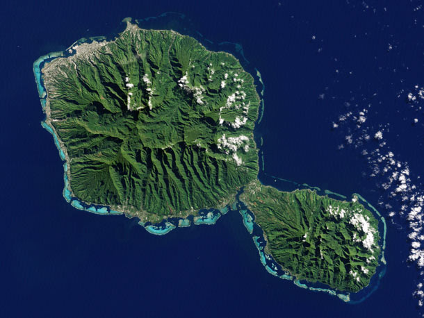
Both shield volcanoes have collapsed, and heavy erosion from rainfall has radically changed their appearance from all that time ago when they formed. This Landsat 7 image makes all that very clear... though I imagine from ground level it's far, far tougher to see.
Original image
Credit: NASA Earth Observatory image by Jesse Allen and Robert Simmon, using Landsat data from the U.S. Geological Survey.
Original image
Blog post
Image credit: NASA
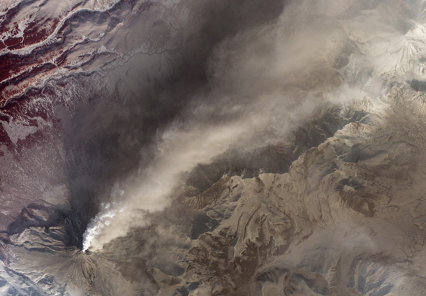
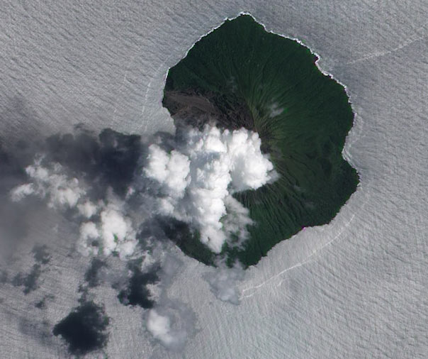
The plume is white and tan, meaning it has water vapor in it as well as ash, and fresh ash falls line the flanks. These may also be from pyroclastic flows - torrential waves of burning hot ash which plow down the slopes at hundreds of kilometers per hour.
Original image
NASA Earth Observatory image by Robert Simmon, using data from the NASA/GSFC/METI/ERSDAC/JAROS, and U.S./Japan ASTER Science Team.