The World’s Newest Island
Last week, on Sep. 24, 2013, a very large earthquake hit Pakistan. At a magnitude of 7.7, it caused a lot of damage, leveling houses all over the district of Awaran. Over 400 people were killed.
However, amidst the wreckage, something new literally emerged: an island.
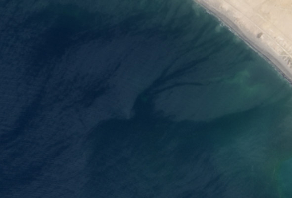
Click, hold, and move the slider bar in the middle of the picture to see before-and-after satellite views of the world’s youngest island. The “before” picture is from April 17, 2013, and was taken by the Landsat 8 satellite; the “after" picture was taken on Sept. 26 by Earth Observing-1.
The island is about 90 meters across (almost 100 yards; the length of an American football field), and rises to about 20 meters (65 feet) above the water’s surface. It formed in the Paddi Zirr, a bay that leads out into the Arabian Sea. The hammer-head peninsula (in the inset picture giving an overview of the region, below), amazingly, is a natural formation, wedged between the two semicircular bays.
The island formed when the quake shook a deposit of natural gas trapped below the surface. This loosened the material above it, allowing the gas to rise, carrying mud, rock, and sand with it. Normally the bay floor is pretty flat, but you can see the slope of the new island stretching for a hundred or so meters around it.

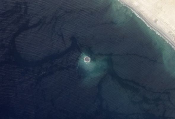
Photo by the National Institute of Oceanography
This picture shows the new island seen from the air; note the ships nosing around to the upper right. The island won’t last long; it’s not solid, and within a few years erosion will tear it down. Apparently this happens with some frequency along the shoreline here; there are many deposits of subsurface gas and seismic activity is common. It’s a fairly remote region of Pakistan, though, so the formation event is not usually seen. Satellite images like these are critical to understanding how ephemeral islands like this are created.

Photo by Jesse Allen and Robert Simmon, using EO-1 ALI data from the NASAEO-1 team
And while you’re boggling over this amazing event, don’t forget the powerful and destructive nature of it. Hundreds of people died, and moreover a magnitude 6.8 aftershock has done further damage. Rescue workers are hampered by poor roads… and to make matters worse, separatist groups are attacking worker convoys coming to help. While I am amazed at the natural forces at work, I am also sometimes cynically revulsed how humans can make a disaster even worse. You can see the human impact in a series of devastating photos at Boston.com’s The Big Picture. Be warned; you may find some of them disturbing.
As I pointed out in a picture I posted recently of a deadly volcanic eruption, these natural events can be tremendously beautiful at the same time they can be profoundly upsetting. Being simultaneously attracted and repulsed by these events, I think, is natural, and something we should embrace. Remember what generates the awe, but bear in mind the human cost.

[Addendum: Although news of this island is everywhere, I want to specifically point out NASA's Earth Observatory Picture of the Day, which has the before-and-after satellite pictures along with very helpful information. Bookmark that site, or put it in your feed reader. It's on my daily must-read list, and is an endless source of truly amazing information.]