A Beautiful and Deadly Island Volcano From Space

I love pictures of volcanoes from space, because they are beautiful and exotic, and give us a sense of the danger and awesome nature of our erupting Earth.

I browse through quite a few, and after a while it becomes easy to get distanced from the actual ground-truth nature of these monsters. That’s natural, I suppose; after seeing a dozen or more, it’s easy to forget that what you are looking at is the fury of our dynamic planet at its most base.
I’ve posted about the lovely island volcano Paluweh before; it’s an eight kilometer (five mile) wide mountain in Indonesia. Its peak, Mount Rokatenda, stretches about 875 meters (a little over half a mile) above the ocean surface. The island is a lumpy circle, pleasing to the eye, covered in vegetation and in photos generally dotted with clouds.
It’s also active. It’s had episodic eruptions historically, and in 2012 started a series of small events that have ejected plumes high into the air, and unleashed pyroclastic flows onto the ground—a swift wave of hot rock and gas that scorch the ground beneath it. Imagine the devastation of a tsunami of water, and now replace that liquid with vaporized rock, and you’ll imagine how terrifying such a thing is.
I knew all that as I found new images of Paluweh taken by Landsat 8, a new Earth-observing satellite launched in February of 2013. Still, the pictures were so pretty I started prepping them to put on the blog. First, let me show them to you:
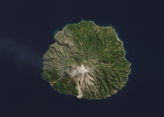
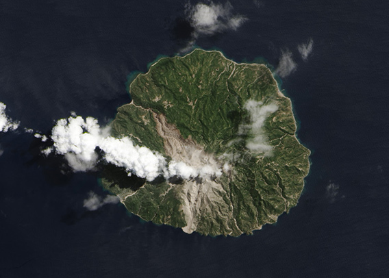
[Photo by NASA/Jesse Allen and Robert Simmon, using Landsat 8 data from the USGS Earth Explorer. Go to the NASA Earth Observatory page for hi-res versions and descriptions of both.]
The pictures are interactive; slide the bar to the right and you see Paluweh from Landsat 8 as it was on Aug. 3, 2013. Slide it to the left and you see the volcano on Sep. 4, 2013, after an eruption left ash blanketing the northwest half of the peak. If you slide back and forth you can see what appear to be more subtle changes, including thicker vegetation in the later image, but more ash deposits scattered here and there.
But what may be subtle in these images is far more obvious from the ground: The eruption which began on Aug. 10, 2013 sent a pyroclastic flow down the slope, funneled by the steep canyon walls, where it rolled over a village and killed five people, perhaps six.
Thousands of people live on the island, and after the recent activity started several thousand were evacuated; those in the red zone near the peak have all left. However, many people are used to the volcano rumbling, and have refused to evacuate. As many as 6000 people may still be on the island.
When I read that, my stomach fell. It was a slap in the face, a stark reminder that the intense beauty of our planet sometimes comes at a price, and a high one at that—something we here in Boulder know all too well.
I will still marvel at these magnificent geologic formations, and still be eager to find more observations of them from orbit. But that admiration will always be tempered by the knowledge that these are far more than just pretty pictures. What you see in them is real, and has a real, and profound, impact on those who live there.