Where’s Obama?
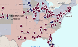
A map of the candidate’s campaign events in red states, blue states, and campaign battlegrounds.
Presidential Campaign Events
 A Romney campaign event
 An Obama campaign event
Red states lean toward Romney.
Blue states lean toward Obama.
Gray states are toss-ups.
Classification based on RCP electoral map
Obama event data scraped from White House schedule

In last week’s map, we showed you where Mitt Romney has been traveling during the 2012 campaign. This week, we’re looking at President Barack Obama’s schedule. The map above, which shows events from the White House schedule, reveals that Obama and Vice President Joe Biden have stepped up their game since Romney became the presumptive GOP nominee in April. In the last two days alone, the president gave four campaign speeches in three states.
Each blue marker on the map is an event listed explicitly as a “campaign event” in the White House schedule; it excludes some public appearances in swing states intended to push specific policies. States that lean toward Romney according to the latest polls are shaded red, and states that lean toward Obama are blue. Battleground states, where polls show neither candidate pulling ahead, are gray.