Weather watchers are going to be especially busy the next few days.
Right now, there are two storms bearing down on the United States: Hurricane Danny, in the Atlantic, is expected to pass very close to Puerto Rico by Tuesday, and in the Pacific, Tropical Storm Kilo is expected to dawdle south of Hawaii before hooking dangerously close to the islands by midweek. They’re happening at the same time, but these two storms will likely produce very different outcomes.
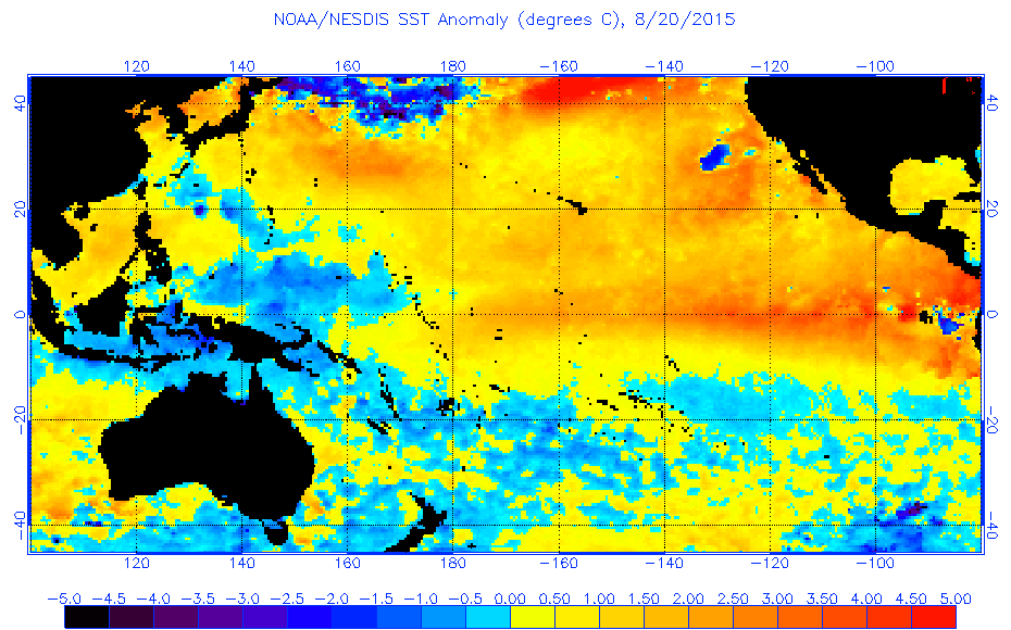
Though Danny is currently much stronger, Kilo is quickly becoming the greater threat. Kilo could be the first hurricane to make landfall in Hawaii since 1992, when Category 4 Iniki devastated Kauai. Current models are still fairly unsure of Kilo’s exact path, but universally suggest that it will be strengthening on its closest approach to Hawaii. El Niño will give Kilo a significant boost: Water temperatures in the vicinity of Hawaii are near an all-time record.
Last year, Hawaii faced three separate tropical cyclone threats, including Iselle, the first tropical storm to make landfall on the Big Island in recorded history. This rare burst of activity has spilled over to a second year, boosted by the abnormally warm Pacific.
Meanwhile, Hurricane Danny—the first Atlantic hurricane of the season—reached Category 3 strength on Friday. But by Friday afternoon, the National Hurricane Center noted that Danny had likely peaked in intensity.
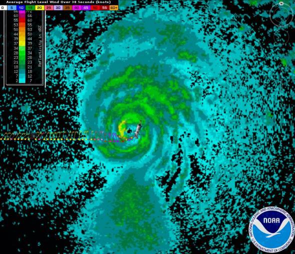
NOAA Aircraft Operations Center
At the moment, the diminutive Danny packs sustained winds of 115 mph near its center, but should weaken considerably before its close brush with the northeast Caribbean islands early next week. Hurricanes as small in size as Danny are known for quick fluctuations in strength, and Danny has already topped official forecasts.
Danny should be reduced to a tropical storm by the time it reaches Puerto Rico—and could wind up being a nearly perfect salve for the commonwealth’s crushing drought.
After that, it’s looking increasingly likely that Danny, in some form or another, will pose a threat to the American mainland. Florida, especially, should keep an eye on Danny’s progress, though it’s still much too soon to know where exactly the storm will track after it leaves the Caribbean late next week. Anywhere from Texas to Maine is currently within the realm of possibility, with Danny arriving at anything from hurricane strength to a glorified afternoon rain shower.
A quick look at storms historically similar to Danny, as the Washington Post’s Brian McNoldy has done below, highlights the reason why the eastern U.S. should keep an eye on it over the coming days.
While such an analysis says absolutely nothing about Danny’s strength once it reaches the mainland—that’s impossible to know right now—it does suggest there will likely be precious few escape routes for the storm to curve safely out to sea should it re-strengthen.