New York state officials voted on Monday to make one of the country’s largest planned transportation disruptions official: New York City’s L train, which carries almost as many daily riders as all of Bay Area Rapid Transit, will shut down between Brooklyn and Manhattan for 15 months beginning in April 2019.
On the one hand, that’s a long time away.
On the other, the Metropolitan Transportation Authority, which runs the subway, has spent more than 15 years rebuilding a single station in Lower Manhattan. The contractor on that project, Judlau, will also take charge of repairing the water-damaged L-Train tunnel. You can see why New Yorkers have begun to feel a sense of urgency about what will constitute Plan B.
Last summer, Sam Schwartz, the New York traffic guru who coined the word gridlock, told me he saw the crisis as an opportunity. “This is a good time for the city to think, ‘Let’s rethink our streets and roads for the L shutdown, but also for what we know is an increasing population,’ ” he said. He recalled how crises past—transit strikes, the Sept. 11 attacks, Superstorm Sandy—had produced innovations like bus lanes, bike lanes, and entire bridges devoted to transit. Imagine a disruption of a similar scale that could be anticipated, for which the city could prepare in advance. The possibility is enticing, and not just for New Yorkers: Projects undertaken in the country’s most pedestrian-friendly city have provided a template for what might be possible elsewhere. (See: the High Line.)
Last summer, I had hoped the shutdown would force “an all-out reconsideration of the way that New York City uses its most transparently mismanaged asset: its streets.” You’d need to run a full, double-length bus into Manhattan every 12 seconds to replace the subway’s rush hour capacity. But nine months later, neither New York City’s Department of Transportation nor the state-run MTA has released a plan, which increases the odds that whatever is devised will be slapdash effort mired in parochial political concerns.
Officials believe 80 to 85 percent of riders will take other subway lines, an outcome that would see tens of thousands of new riders transferred to other lines—including the 7 and A/C trains—that are already at or near capacity. It will be messy unless the city tries to make surface transportation competitive with the subway.
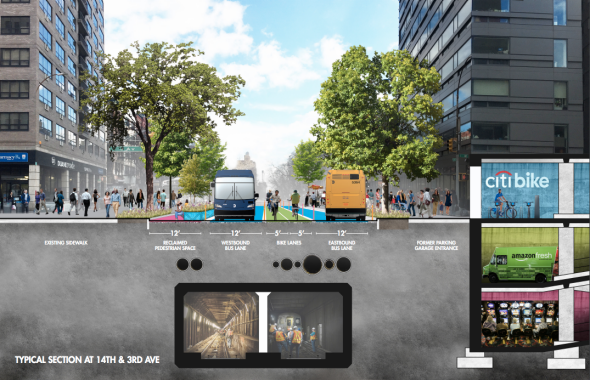
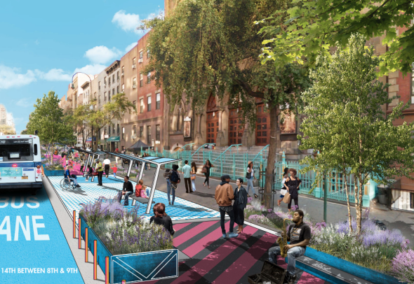
Transportation Alternatives, which advocates for more nonvehicle space on New York streets, has called for the transformation of 14th Street, one of Manhattan’s busiest crosstown arteries, into a two-mile “People Way” that would limit private car use to increase space for buses, bikes, and pedestrians. And so it did what transportation people do when they get feisty: It announced a design contest.
Even for a city that steadily took road space from cars under transportation commissioner Janette Sadik-Khan, retaking 14th Street for pedestrians, bikes, and transit would be the city’s most radical shift in street use in recent memory. (Across the pond, meanwhile, Paris just turned a highway into a park.) The winning entries in Transportation Alternatives’ contest all go further, ensuring that transit has a clear path from Brooklyn to Manhattan.
The third-place entry, by the architect James Wagman, advocates creating pedestrian “superblocks” along the train’s Manhattan route, diverting most private vehicle traffic to a handful of avenues. The second-place entry, by the Practice for Architecture and Urbanism, envisions temporary changes to the streetscape as a “pilot for the long-term surface mobility of our city.” It calls for a boroughwide streetcar system and a “Silver Line” bus rapid transit pilot, modeled after Bogotá’s TransMilenio system, on 14th Street.
Transportation Alternatives/14thST.OPS
But the winning proposal, by 14th ST.OPS—the urban-minded friends Cricket Day, Becca Groban, Christopher Robbins, and Kellen Parker—is the most radical: Its design changes to 14th Street are similar, but it also provides for a Brooklyn Shuttle with a dedicated space on the Williamsburg Bridge and on Lafayette and Delancey streets, connecting the new “People Way” with Kings County.
Fourteenth Street, then, may be the flashy piece of urban design that emerges from the shutdown: a reclamation of street space for people that could be invoked to show what’s possible in other American cities, or even further uptown on 34th Street.
But it’s the connection between Manhattan and Brooklyn that will test the city’s and state’s determination to change the status quo. Schwartz, the transportation planner, hopes the shutdown provides the spur for his Move New York plan, a realignment of the city’s bridge and tunnel tolls that would constitute America’s first congestion pricing plan. (The Williamsburg Bridge is currently free while the tunnel two miles north costs a driver $8.50 in cash.)
What happens within Brooklyn to get all those riders to their new trains will also require that the city and state rethink their approach to streets. Buses in New York have lost 16 percent of their ridership since 2002 (similar declines have occurred nationwide). The MTA’s chief financial officer says people stopped riding buses because the subway is so good. Also, though: The buses are bad.
When the train shuts down, the city and state will have to find a way to make buses fast, easy, and frequent. That, above all, could be a lesson for other U.S. cities. But time is running out.