After what felt like the fleetingist of summers, here’s the news that snowophobes have been bracing for since the last polar vortex: It looks like winter is coming early this year.
It’s only the first week of November, and America has already had two record-breaking snowstorms. Considering Columbia, South Carolina, beat Boston, New York City, and Fargo (yes, Fargo) for the first 1-inch snowfall of the season, we may be in for another weird winter.
Over the last few weeks, seasonal climate models have shifted more and more toward the idea that this winter will be a doozy. Now that we’re within shorter range, the odds of recurring cold snaps—at least for the rest of November—are increasingly certain. Over the last few days, shorter-term weather models have locked on to the growing likelihood that—for the Eastern United States, at least—winter starts now.
A wintery East Coast may be hastened by one of the strongest storms on Earth in 2014, Super Typhoon Nuri, set to morph into a Bering Sea extratropical cyclone over the next few days.
According to the National Weather Service, the remnants of another Pacific cyclone, Hurricane Ana, was partly responsible for the snows in South Carolina this past weekend. Ana made a close brush with Hawaii last month before turning toward the Pacific Northwest.
There are other long-range signals that continue to point toward a particularly cold November, like the continued unseasonably large extent of Eurasian snow cover, a predicted burst of warming in the stratosphere, and a “ridge bridge” pattern that typically allows far northern Arctic air to spill southward toward the East Coast. All these signals point toward instability in a building dome of very cold air over the North Pole that could pour southward at any moment.
Here’s what’s coming next week, for example:
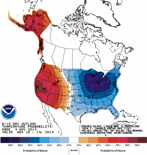
Image: NOAA CPC outlook for Nov. 10-14
For the Twin Cities, that means next Wednesday’s high temperature may top out below 20 degrees—the normal high for the last week of January, usually the coldest part of the year. The recently upgraded GFS model and the European ECMWF model are both showing a similar pattern intermittently for at least the next few weeks.
The flip side of this pattern, as with last year, is abnormal warmth for the West. The same general pattern has been recurring for more than a year now and has been blamed for worsening the California drought and pushing that state toward its warmest year on record. A recent study led by a Stanford researcher showed the pattern was at least three times more likely to form because of global warming.
Aiding in this pattern is an unusual warming of the Pacific Ocean, just off the West Coast. The region currently features the warmest waters in decades, according to the Washington Post’s Capital Weather Gang.
Since last winter, the science linking extreme winter weather with climate change has strengthened. Studies in May and June said wavier jet stream patterns are occurring more frequently in a warming world. In September the author of a new paper on the subject called the recent occasional destabilization of the polar vortex a “side effect of global warming.”