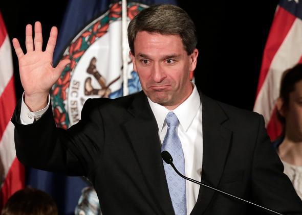
By a country mile, the most fun explanation I’ve seen for the defeat of Ken Cuccinelli in Virginia comes from Steve Jalsevac, a co-founder of the anti-abortion LifeSite News. Jalsevac shows readers a picture of the state’s election map, and asks them if they want to live in such a crazy world.
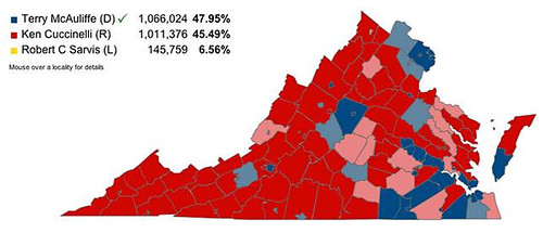
All the solid red areas voted a majority for Cuccinelli. The small dark blue ares went Terry McAuliffe (Yes, I know those are the most densely populated areas of Virginia). The rest were mixed. Notice that the map seems to be almost solid red. And yet, Ken Cuccinelli somehow very narrowly lost to his Democrat opponent. To me, something smells about all this and I suspect Ken Cuccinelli actually won Virginia, but certain things happened to ensure that that would not be the official result.Just a crazy analysis on one site, but you have to appreciate this sort of magical thinking for three reasons. 1) It gives false hope on election nights. Here, for fun, are two other maps of close races.
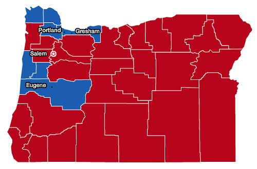 That’s the 2008 race for U.S. Senate in Oregon. Democrat Jeff Merkley won seven counties, and won the election as ballots around Portland were counted. I remember driving through Georgia listening to talk radio and hearing confident predictions of how Merkley would lose because with 90 percent counted, he was still down.
 That’s the 2012 election in Pennsylvania, won by Barack Obama after the legendary “late play” made by Mitt Romney. The president won a mere 12 counties, but deviously chose the ones that humans lived in. On all three election nights (2008, 2012, 2013), you could hear conservatives blowing the predictions because they didn’t know where the votes were.
2) The false hope leads to mistrust. At Cuccinelli’s election night party, I overheard some Republican voters grousing about how Democrats were probably holding back Fairfax County so it could supply the last votes they needed. Yes, Fairfax County, a suburban area that voted Republican for president as recently as the year 2000—this was our new Chicago, our new Rio Grande Valley. It sounded crazy, yet it was the thinking that led a powerful Republican to insist that voter ID would let Mitt Romney win Pennsylvania—cancelling out those 200,000 fraudulent votes from Philly—and encourages Republican election-watchers in Fairfax County to tighten standards on the votes they’re counting, after the election’s over.
3) The “hey, look at all that red” theory skews our view of which party represents “real America,” or “most of” America. It also ends up justifying gerrymandering. Republicans now wipe Democrats out in most of white, rural America, something that only really got underway in the Bush years and has become stark under Barack Obama.* When Obama won Ohio, he took only 17 counties, mostly the ones with population centers. When Jimmy Carter won Ohio, by a smaller margin, he won 28 counties. It wouldn’t actually be tougher to draw a competitive map of Ohio now than it was then, but when the majority party gets wiped out with rural whites and gets over the line with urban black voters, it’s easy to pack their base into a smaller number of districts and argue that you’re being fair.
*When Mike Dukakis lost to George H.W. Bush, he won 33 counties in Oklahoma. No Oklahoma county has voted Democratic for president since 2000. Cherokee County was closest in 2012—Obama merely lost it by 14 points, while losing the state by 34 points.
Correction, November 11, 2013: This post originally said Obama lost Cherokee County by 16 points.
That’s the 2012 election in Pennsylvania, won by Barack Obama after the legendary “late play” made by Mitt Romney. The president won a mere 12 counties, but deviously chose the ones that humans lived in. On all three election nights (2008, 2012, 2013), you could hear conservatives blowing the predictions because they didn’t know where the votes were.
2) The false hope leads to mistrust. At Cuccinelli’s election night party, I overheard some Republican voters grousing about how Democrats were probably holding back Fairfax County so it could supply the last votes they needed. Yes, Fairfax County, a suburban area that voted Republican for president as recently as the year 2000—this was our new Chicago, our new Rio Grande Valley. It sounded crazy, yet it was the thinking that led a powerful Republican to insist that voter ID would let Mitt Romney win Pennsylvania—cancelling out those 200,000 fraudulent votes from Philly—and encourages Republican election-watchers in Fairfax County to tighten standards on the votes they’re counting, after the election’s over.
3) The “hey, look at all that red” theory skews our view of which party represents “real America,” or “most of” America. It also ends up justifying gerrymandering. Republicans now wipe Democrats out in most of white, rural America, something that only really got underway in the Bush years and has become stark under Barack Obama.* When Obama won Ohio, he took only 17 counties, mostly the ones with population centers. When Jimmy Carter won Ohio, by a smaller margin, he won 28 counties. It wouldn’t actually be tougher to draw a competitive map of Ohio now than it was then, but when the majority party gets wiped out with rural whites and gets over the line with urban black voters, it’s easy to pack their base into a smaller number of districts and argue that you’re being fair.
*When Mike Dukakis lost to George H.W. Bush, he won 33 counties in Oklahoma. No Oklahoma county has voted Democratic for president since 2000. Cherokee County was closest in 2012—Obama merely lost it by 14 points, while losing the state by 34 points.
Correction, November 11, 2013: This post originally said Obama lost Cherokee County by 16 points.