ROYAL OAK, Mich. – As you turn your Oscar ballot over and write your Michigan Primary Predicto-Graf, here’s an item that’ll help out. It’s USElectionAtlas’s map of the 2008 Michigan GOP race, by congressional district.
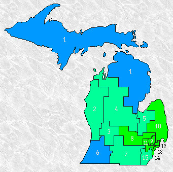 Delegates are assigned proportionately in Michigan. The winner of the state gets all at-large delegates, and the winners in each congressional district get their claims on local delegates. In 2008, John McCain only won two districts, in bright-red southwest Michigan and in the conservative Democratic terrain of northern Michigan. (That district was represented by Bart Stupak until 2010.) Rick Santorum’s hopes for a delegate win rest on a much stronger performance in western Michigan, where both John McCain and Mike Huckabee ran stronger than they ran statewide. His hope for an overall win: Eat into the Romney margin in metro Detroit. In 2008 Romney won Oakland and Macomb counties by 20 points, and Wayne County by 18.
Map of the Day: The 2008 Michigan Battlefield
Advertisement