The Vault is Slate’s history blog. Like us on Facebook, follow us on Twitter @slatevault, and find us on Tumblr. Find out more about what this space is all about here.
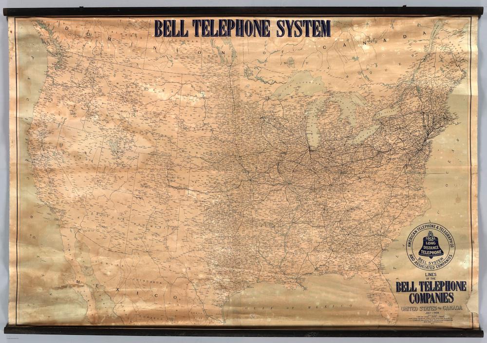
There were 5.8 million telephones in the Bell/AT&T network in 1910, when this map was published. It shows the uneven development of early telephone service in the United States, and gives us a sense of which places could speak to each other over Bell’s long-distance lines in the first decade of the 20th century.
The Bell Telephone Company, which was founded in 1877, faced some competition early on from Western Union, but then enjoyed a virtual monopoly on telephone service until 1894, when some of Bell’s patents expired. Sociologist Claude Fischer writes of the years after that expiration: “Within a decade literally thousands of new telephone ventures emerged across the United States.” Some of those independents went into rural areas that Bell had not covered, because the company had focused on developing service in the business centers of the East Coast.
By the time this map was printed, Bell had tried several different strategies, clean and dirty, to fight back against its competition, including (Fischer writes) “leveraging its monopoly on long-distance service,” pursing patent suits, controlling vendors of telephone equipment, and simply using its deep pockets to outlast smaller companies that tried to enter the market.
Theodore N. Vail, who took over in 1907, changed strategies, accepting limited government regulation while buying competitors or bringing them into the Bell system. The map shows Bell’s market penetration in 1910, three years after Vail took over. Some rural areas—Oklahoma, Iowa, northern and eastern Texas—are surprisingly well-covered, while others in the Southeast remain empty.
The discrepancy between coverage in the East and the West is perhaps the most striking aspect of the map. California remains sparsely served, and no long-distance lines reach all the way from coast to coast. AT&T constructed the first transcontinental line in 1914.
Click on the image to reach a zoomable version, or visit the map’s page on the David Rumsey Map Collection site.
David Rumsey Map Collection.