Interactive Map Shows Impact of WWII Firebombing of Japan, if It Had Happened on U.S. Soil
The Vault is Slate's history blog. Like us on Facebook, follow us on Twitter @slatevault, and find us on Tumblr. Find out more about what this space is all about here.
When we talk about the bombing of Japan during the World War II, we usually focus on Hiroshima and Nagasaki. But before the atomic bombs, the United States had already begun a ruinous campaign of bombing Japanese cities with incendiary weapons. Over 40,000 tons of napalm bombs were dropped on Japanese cities before the atomic bombings took place.
The U.S. Army Air Forces took great pride in their handiwork. They were not especially happy when the atomic bombs were given the lion’s share of credit for ending the war. In their minds, it was their firebombing that had reduced Japan to such a state that the atomic bombs, and the Soviet invasion of Manchuria, resulted in rapid capitulation.
To bolster their case, they created a remarkable set of maps showing the devastation wrought on Japan from the air. I took the data used in making these maps, including the population counts from 1940 U.S. Census, and made this interactive version, where you can visualize the sizes of the cities, the amount of damage done, and the corresponding U.S.-Japanese locations.
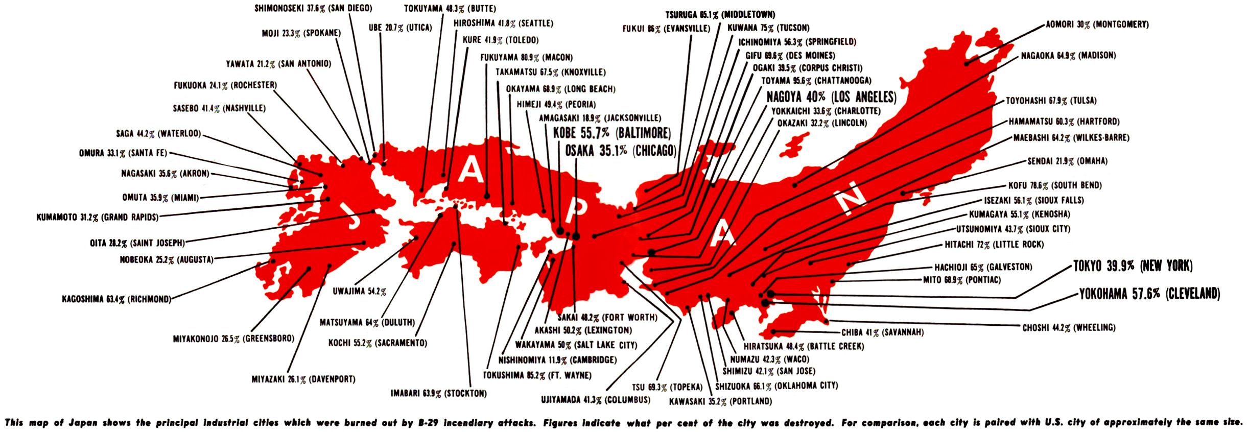
One of the original maps, published in November 1945, showed the top 69 bombed-out Japanese cities and their location on the island. Each city was indicated with the percentage of it that was destroyed, and the name of an American city of equivalent size (based on population counts from the 1940 US Census). Hiroshima and Nagasaki were included on the map—but as just two bombings out of dozens.
A second remarkable map elaborating on this theme was published in the final, late-1945 issue of a classified (“confidential”) U.S. Army Air Forces magazine titled IMPACT. You can see that map below. Here the same data was used, but to a very different effect. Instead of plotting the Japanese cities on Japan, they were plotted on the United States, with the heading, “If it were U.S.” The text explained:
If the 69 U.S. cities on the map at right had been battered by Jap bombers free to strike any time and anywhere in this country, you can vividly imagine the frightful impact it would have had upon our morale and war potential. Yet this is precisely what the B-29s did to Japan.
The two maps powerfully depict the extent of the devastation, but this isn’t some kind of anti-bomber screed—it’s the opposite. It’s the bombers bragging about the terrifying importance of firebombing.
A longer version of this post appeared on Alex Wellerstein’s blog, Restricted Data. Click on the map below to zoom.

IMPACT magazine, 1945. Image courtesy Alex Wellerstein.