The Vault is Slate’s history blog. Like us on Facebook, follow us on Twitter @slatevault, and find us on Tumblr. Find out more about what this space is all about here.
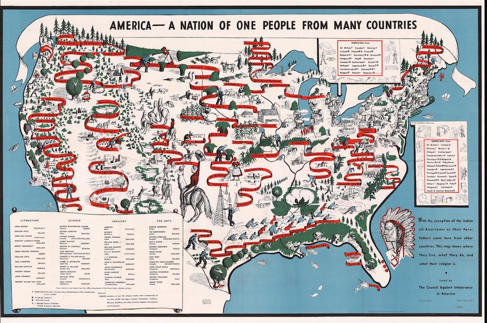
This map, issued by the Council Against Intolerance in America in 1940, shows the ethnic groups living in the United States, offering a picture of their geographical locations, typical employment, and religious commitments. The document was owned by poet Langston Hughes, and is collected in his papers at Yale’s Beinecke Rare Book & Manuscript Library.
The map omits state boundaries, opting instead to show the mix of ethnic groups by area. For heavily-populated areas, such as the Northeast or Chicago, pop-out keys framed with line drawings of people engaged in typical industries show the diversity of urban citizenry.
The Council Against Intolerance, a New York group active from the late 1930s through the mid-1940s, was founded by left-leaning Jewish author James Waterman Wise. Wise is notable for having warned of the dangers of Nazism in several books as early as 1933.
The Council’s educational department printed teachers’ manuals and books to be used in adult reading groups. The group’s rhetoric was pro-American, arguing in its materials that prejudice would undermine national unity in a time of war.
The map’s images in the Southern part of the United States, of African-American and white sharecroppers bent together over bales of cotton, seem to have provoked Hughes to commentary. In a red pen (now faded to pink), he drew a burning cross near the workers, writing “KKK” underneath.
Alongside an illustration of a textile factory, Hughes added an ironic reference (and possibly a nod to the song “Ol’ Man River,” from the 1927 musical “Show Boat”): “Tote that cotton—Roll that bale!”
Click on the image to zoom.
Beinecke Rare Book & Manuscript Library, Yale University.