The Vault is Slate’s history blog. Like us on Facebook, follow us on Twitter @slatevault, and find us on Tumblr. Find out more about what this space is all about here.
This 1849 map, printed by Ensigns & Thayer, a New York firm, offered advice to prospectors bound for the California gold fields during the rush of 1848-1864. A half-million people flooded into the territory during these years, and many were woefully under-provisioned and ill-informed. Authors both credible and fraudulent stepped into the breach, publishing advice books for prospective miners, complete with maps, packing lists, and guides to telling real gold from the fool’s variety.
Ensign & Thayer, like other mapmakers of the time, capitalized on the sudden frenzy to emigrate by reissuing older maps with updated annotations. This map, however, appears to be a completely new design, made specifically for prospectors. The gold fields of the Sierra Nevada are highlighted in a glowing yellow.
The view of North and South America presumes that the travelers using this particular map will enter California through San Francisco, not travel overland across the continent. In the time before the completion of the first transcontinental railroad (1869) and the opening of the Panama Canal (1914), travelers to California had few easy options. The map outlines three, and, in the text at the bottom of the page, warns gold-seekers of the dangers of each.
The Panama route was scantily provisioned, and the climate “produce[d] bilious remittant [sic] and congestive fevers.” (Ulysses S. Grant, who traveled with a regiment of the U.S. Army via this route to San Francisco in 1852, reported in his memoirs that fully a third of his party died of cholera in Panama.) The journey around Cape Horn was slowest, at five months’ travel time, but also cheapest, and you could avoid the uncertainty associated with crossing the Isthmus of Panama.
Some might opt to cross Mexico and then sail up the coast. This option came with its own perils, the map warns: “To prevent danger of being attacked by robbers through Mexico, persons should go in groups of 40 to 50, or more.”
Click on the map below to reach a zoomable jpeg, or visit the map’s page on the David Rumsey Map Collection website.
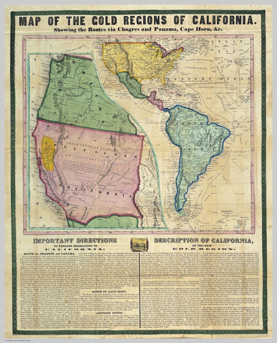
New York, 1849.
David Rumsey Map Collection.