The Vault is Slate’s history blog. Like us on Facebook, follow us on Twitter @slatevault, and find us on Tumblr. Find out more about what this space is all about here.
This map, printed in 1875 by the Army’s Provost Marshal General’s office, uses data gleaned from the Union Army draft during the Civil War to show the prevalence of syphilis across various Union states. An early attempt to track disease using cartography, the map took advantage of the wealth of data provided by conscription examinations. It cannot trace causes of outbreaks but does succeed in highlighting the locations that yielded up highly syphilitic male populations (Waukesha, Wis.; Lexington, Ky.; and Boston, among others).
In the 19th century, before the availability of antibiotics, having syphilis was a dangerous enough condition to exempt a person from the draft. Left untreated, the disease could cripple a person, with symptoms including rashes and chancres, fevers, headaches, fatigue, paralysis, blindness, and dementia.
An 1864 Manual of Instructions for Enlisting and Discharging Soldiers, issued by the assistant surgeon of the U.S. Army, instructed examining physicians to reject all sufferers who had shown signs of syphilitic infection through “eruptions of the skin and mucus membranes.” “The constitutional infection,” the surgeon wrote, “is almost never cured, and will be surely roused into activity by the exposure and unfavorable hygienic conditions to which the soldier is subjected.”
Elsewhere in the report that contains this map, a chart compared draftees’ syphilitic status to other factors, some of them seemingly more related than others: “social condition” (many more single men than married were sufferers); “complexion” (“light” was more syphilitic than “dark”); age (those between 20 and 25 were most at risk); height (incomprehensibly, being between 63 and 67 inches was a slight risk factor); and “nativity” (South Americans, “Spanish,” and Mexicans were recorded as most commonly infected).
Click on the image below to reach a zoomable version.
Thanks to historian Susan Schulten, who wrote about this report in her Mapping the Nation: History and Cartography in Nineteenth-Century America.
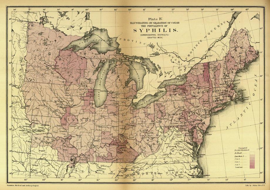
J.H. Baxter, “Illustrating By Gradation of Color the Prevalence of Syphilis,” in Statistics, medical and anthropological, of the Provost-Marshal-General’s Bureau, derived from records of the examination for military service in the armies of the United States during the late war of the rebellion (Washington, DC: US Gov’t Printing Office, 1875).
See more of Slate’s maps.