The Vault is Slate’s history blog. Like us on Facebook, follow us on Twitter @slatevault, and find us on Tumblr. Find out more about what this space is all about here.
This is a souvenir fold-out map given to passengers taking a transcontinental trip by air in 1929. On the back, it features a weather map, a “Certificate of Flight,” and a flight log, to be filled out by the passenger. Its actual dimensions are 14 inches tall by 30 inches wide, and it folds into a “pocket” size of about 4 inches by 7 inches.
Transcontinental Air Transport, Inc., the company that manufactured the map, looked to capitalize on the nation’s new love affair with aviation by providing a sightseeing experience unlike any other. TAT, founded in 1928, constructed a glamorous image, riding on the fame of its celebrity promoters, who came from Hollywood and aviation royalty. These included Charles and Anne Lindbergh (Charles had a financial stake in TAT), Mary Pickford and Douglas Fairbanks, and Amelia Earhart.
Despite the company’s name, the trip was not quite transcontinental—as you can see on this map, passengers took a train to Columbus, Ohio, then another from Waynoka, Okla. to Clovis, N.M. In between, they flew in Ford Tri-Motor planes with a capacity of 10 to 12 passengers and wicker seats.
Passengers flew by day so they could see the sights and slept on the trains at night. The map’s borders feature scenes of the American landscape, showing places that the passengers could expect to see from the ground (Clovis’ main street) and from the air (the campus of the University of Missouri, Los Angeles’ new City Hall).
The trip took 48 hours altogether in ideal conditions. David Rumsey notes that on the back of this map, Mason Menefee, the passenger who owned it, filled in his flight log “indicating that weather trouble en route caused delays and additional travel by train.” “A few passengers,” Menefee added, “very mad.” Apparently, this experience was not uncommon; TAT’s nickname was “Take a Train.”
Altogether, the venture was too ambitious for its own good. The company lost $2.7 million in a year and half. TAT merged with Western Air Express in 1930, and the new company, known as Transcontinental and Western Air, or T&WA, provided airmail service. In 1950, the company changed its name to Trans World Airlines and became the familiar TWA.
Click the image below to arrive at a zoomable version, or visit the map’s page on the David Rumsey Map Collection website.
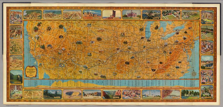
“Illustrated Map of the Route of Transcontinental Air Transport,” Rand McNally for TAT, 1929. David Rumsey Map Collection.
See more of Slate’s maps.
Correction, October 8, 2013: This post originally misidentified Waynoka, Okla. as Waynoka, Kan.