The photograph of a drowned Syrian child on a Turkish beach galvanized public attention around the European refugee crisis. Its effect on fundraising was huge: The United States Fund for UNICEF reported a 636-percent spike in donations, the U.N.’s refugee agency raised $17 million in less than a week, and donations flooded local charities. Even so, the aid isn’t enough. Migrants face increasingly desperate situations as Europe tightens its borders.
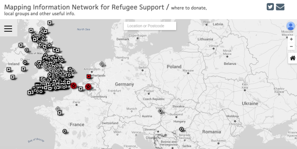
To help consolidate hundreds of grass-roots groups across the EU, a new website is mapping donation hubs and fundraising events with crowd-sourced data. The main goal of the London-born Refugee Maps is simple: to create an easy-to-use, centralized platform for people looking to contribute. Launched Sunday, the site has mapped nearly 400 location points and registered more than 30,000 views. “We have the skill, systems and technology to deal with large volumes,” one of the site’s developers, Pranay Manocha, told Slate by email.
When you click on a geographic point (designated as drop-off hub, collection spot, group or demonstration) on the gray-scale map, the name of the organization and its Facebook or website link pops up. It’s easily searchable by region and allows people to submit data through a Google Form.
Refugeemaps.org
Right now, the network is mostly contained within the United Kingdom. That’s because the map was originally focused on the refugee crisis in the French coastal town of Calais, the main migrant entry point into the U.K. Dubbed the “Jungle,” the Calais refugee camp houses nearly 4,000 migrants hoping to cross the English Channel. The camp—one of the biggest in Western Europe—resembles a small village.
The humanitarian group Calais Action created a static Google Maps platform to connect potential donors with charity centers in their community. The Guardian helped promote it, encouraging people to submit the details of organized collections through an online form.
Refugee Maps is a replacement of the first platform. The new site uses Google’s Fusion Tables, a data-visualization tool that’s still in beta. According to the map’s developer, Fusion Tables is more visually appealing and offers extra potential in the kind of data they can display.
On Thursday, the site mapped Croatian land mines using data from the Croatian Mine Action Centre. With the Hungary-Serbian border closing, migrants are now taking an alternative route through Croatia, where there are nearly 60,000 land mines in the ground leftover from the Balkan Wars of the 1990s. As the Washington Post reports:
Aid groups and local migrant advocacy organizations are urging those contemplating this new route to stick to highways and avoid deserted fields, though that’s easier said than done, given the risks that many making the trek have already taken.
Refugee Maps is adding more points across the EU every day. But it still needs a lot more public participation to be comprehensive. Tristan Day, a volunteer with Calais Action who helped spearhead the map is optimistic: “Let people know you’re there and that you’re doing something, it’s amazing how quickly others will rally round to support you.”