Global warming is about to get a boost.
As this year’s El Niño sets in, early signs are pointing toward the possibility of a rare occurrence: back-to-back El Niño years. If it happens, it would virtually guarantee a new global heat record in 2015 and could help usher in a decade or more of accelerated warming.
Think of El Niño as a burst of heat emanating from the tropical Pacific, setting off a cascade of worldwide impacts. This year’s El Niño is already poised to make 2014 the planet’s warmest year on record, according to a recent NOAA estimate.
Last month, global oceans were the warmest they’ve ever been measured, boosted by the cumulative heating linked to human emissions of greenhouse gases. Should current forecasts hold, the National Oceanic and Atmospheric Administration is expected to confirm the official start of El Niño conditions for 2014-15 in the next month or two.
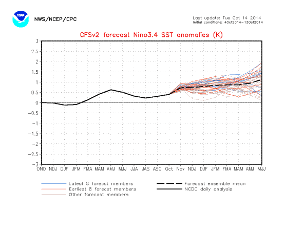
Image: NOAA CFSv2
NOAA’s leading seasonal climate forecast model, the CFSv2, is starting to hint at a renewed uptick in the primary El Niño ocean temperature index during 2015 (shown above). Still, a double-dip El Niño is by no means set in stone. A lot can change in a year, and the CFSv2 model didn’t do particularly well on the current impending El Niño. (To be fair, neither did many others.)
Tony Barnston, the lead climate forecaster for Columbia University’s International Research Institute for Climate and Society, is equivocal. “It’s a possibility, but it doesn’t happen often, and to call for it would show an inappropriate level of confidence in my opinion. A few other models besides CFS are also hinting at this [possibility of back-to-back El Niños],” said Barnston.
Even if there’s not a second El Niño, a longer-term climate signal is beginning to point in the direction of more frequent bursts of warming over the next several years. Over the next few years, a natural climate oscillation known as the Pacific Decadal Oscillation (PDO) is poised to kick into gear. Historical data has linked the “warm” phase of the PDO with a 15- to 30-year temporary surge in global temperatures. A new paper even shows this sort of natural variability could trump long-term human-caused climate warming in localized areas like the Pacific Northwest.
The PDO can be thought of as the atmospheric manifestation of a stretch of frequent El Niño events. If El Niño is the spark that ignites a months-long transfer of heat between the ocean and the atmosphere, the PDO is an indicator of how much fuel is in the gas tank.
The only problem is, it’s pretty much impossible to tell if one of these PDO surges are coming until we’re mired in it. There have been only two complete “cycles” of the PDO since the early 20th century—a warm phase from around 1920-1945, and another one from 1975-1998—both of which coincided with bursts of warming on the global scale. Still, the PDO’s slow-moving nature means researchers haven’t had many chances yet to test predictive theories.
Efforts to explicitly forecast the PDO are, understandably, still pretty messy. The current possible shift to a positive state wasn’t very well forecast at all, for example. Lisa Goddard, director of Columbia University’s IRI, agrees. “We usually can’t really say what phase of the PDO we are in until we have been there for 5-10 years,” she said in an email to Slate.
Recent data shows that transition may already be underway to a new warm phase. Since January of this year, the PDO has been on a tear, coinciding with the so-called “Ridiculously Resilient Ridge” of high pressure that’s camped off the California coast. Meteorologists have linked this feature to California’s intensifying drought, which is already the worst in generations. Recent sightings of tropical fish off the coast of Alaska—like ocean sunfish and skipjack tuna—are further evidence of unusual ocean warming.
Natural oscillations like El Niño and the PDO are the noisy variations on the long-term trend of global warming. It’s like trying to track the path of your dog when you’re out for a walk—in the short run, global temperatures may seem chaotic, but the ultimate direction is clear. In this case, that direction is up.