Wildfire season is in full swing out West, and the numbers are already staggering.
This month has featured two of the biggest wildfires ever seen on the West Coast:
- The Carlton Complex, which is about 140 miles west of Spokane, is the largest fire in the history of Washington state. It’s only 66 percent contained and has burned about 250,000 acres (nearly 400 square miles). That’s four-and-a-half times larger than the city of Seattle.
- The Buzzard Complex, an even bigger fire, is still burning in southeast Oregon, though it’s almost completely contained. At 395,000 acres (more than 600 square miles), it’s surprisingly not the biggest in that state’s history—that dubious title goes to the 2002 Biscuit Fire, which burned more than 500,000 acres and took five-and-a-half months to fully contain.
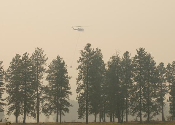
Two new fires grew over the weekend in California, burning homes near Sacramento and just outside Yosemite National Park. The El Portal fire near Yosemite quadrupled in size Sunday night and remains almost completely uncontained.
While the East enjoys another polar vortex-lite stretch of pleasant weather this week, that same pattern is threatening a resurgent heat wave that will bake the West, only adding to the risk that other fires might get out of control under unusually dry conditions. A surge of monsoon moisture will bring a wildcard: Heavy rains are possible across the Southwest, but lightning strikes may spark fresh flames.
Earlier this year, in my Thirsty West tour of drought stricken California, I wrote that thanks in part to global warming, at least in that state, and at least in 2014, fire season is now year-round.
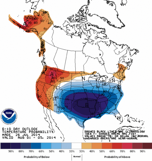
Image: NOAA
Slate’s Josh Voorhees wrote last week about the increasingly political nature of the West’s growing fire problem, which has placed a heavy burden on communities and states struggling to distribute scarce resources:
In the past four decades, the length of the wildfire season has increased by more than two months. The average wildfire, meanwhile, now burns roughly twice as long and consumes twice as many acres than it did a decade ago. Since 2010, the number of structures destroyed by the fires has tripled, and firefighter fatalities have soared by a factor of four, according to the nonprofit research group Headwaters Economics. The Obama administration estimates it will spend $2.4 billion this year battling the blazes, nearly triple what was spent in an average year two decades ago.
During that same time, there’s been a building boom where Western cities meet the forest, putting more people and property at risk. More and more, megafires are becoming mega disasters. But what if there were a way to figure out, within hours of the first plumes of smoke, which fires pose an undue threat, and which ones will likely remain isolated?
Previously, these sorts of predictions were thought to be impossible, given the complicated interactions between vegetation, winds, humidity, and the terrain of the intermountain West. To top it off, accurate predictions need access to hyperlocal data, which simply hasn’t been possible until recently.
But now it seems increasingly possible to forecast the behavior of megafires in real time. Thanks to science (and hefty computing power), researchers at the University of California-San Diego, the University of Maryland, the National Center for Atmospheric Research, and other institutes around the country are working on projects that attempt to do just that.
On a recent trip to the National Center for Atmospheric Research, I spoke with Bill Mahoney, who is working to model wildfire behavior with NCAR researcher Janice Coen. (Disclosure: NCAR paid for my visit to the center.)
The smoke-and-fire generating model was once humorously called the CAWF model (short for “Coupled Atmosphere-Wildland-Fire”). Mahoney says they added an “E” on the end (for “environment”) because “we thought that was too much.” The model’s acronym is pronounced “coffee.”
Using infrared fire-spotting satellites and a series of equations that describe the complex interactions between the smoke, dust, and heat that’s spewed into the atmosphere, researchers have developed a predictive tool to represent fire behavior in high resolution on a minute-by-minute basis. The result is a model that simulates the growth of megafires, which can occasionally grow so complex they can modify surrounding weather patterns. Said Mahoney, “this could be a game changer for safety and the management of wildland fires.”
As a test, the NCAR researchers tried to accurately resolve the complex fire behavior in last year’s Yarnell Hill fire in Arizona, which killed 19 firefighters after strong winds from a nearby thunderstorm quickly made the fire do a 180-degree about-face. The firefighters couldn’t get out of the way fast enough. Mahoney says future tragedies like Yarnell Hill could be prevented.
“If this tool was available operationally: you could easily say, here’s a day where thunderstorms might be generated, quick 180 degree change in the winds, so don’t get too close to the fire.”
The model is so detailed, it can even resolve fire whirls—also known as firenadoes.
The CAWFE model is still in the research stage, and researchers are looking for funding to scale it up into real-time mode as quickly as possible. But the model is still at least three years from seeing the front lines, thanks to bureaucratic wrangling. “There’s a bit of a jurisdictional issue here: Is it housed in NOAA or the Forest Service?” Mahoney told me. Traditionally, NOAA—the National Oceanic and Atmospheric Administration—forecasts the general favorability for wildfire growth on a given day. Once a fire forms, the Forest Service usually calls the shots on active fires.
When asked how long it might be before we use satellite to flag new fires, use the model to predict it, and then send drones out into the field to fight them, Mahoney smirked: “That’s a very realistic scenario.”