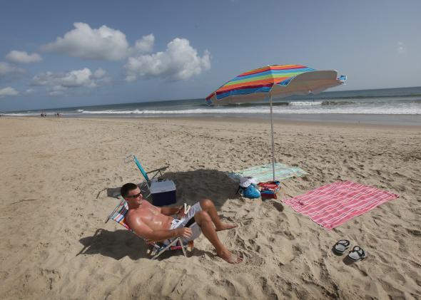
Buckle up, Carolinas. You’re about to get some natural fireworks this Fourth of July.
The tropical system that’s been brewing all weekend has received an official upgrade to Tropical Storm Arthur by the National Hurricane Center.
In its 11 a.m. update on Tuesday, the National Hurricane Center said the storm remained nearly stationary about 95 miles offshore of Cape Canaveral, Florida. Over the next two days or so, the storm will gradually begin to be pulled northward toward the Carolinas by an approaching cold front—the same cold front that spawned powerful storms that knocked out power to more than 500,000 people late Monday night in Chicago and other parts of the Midwest.
The latest official “cone of uncertainty” from the National Hurricane Center shows Arthur reaching hurricane status just before an early morning brush with the North Carolina Outer Banks on July 4:
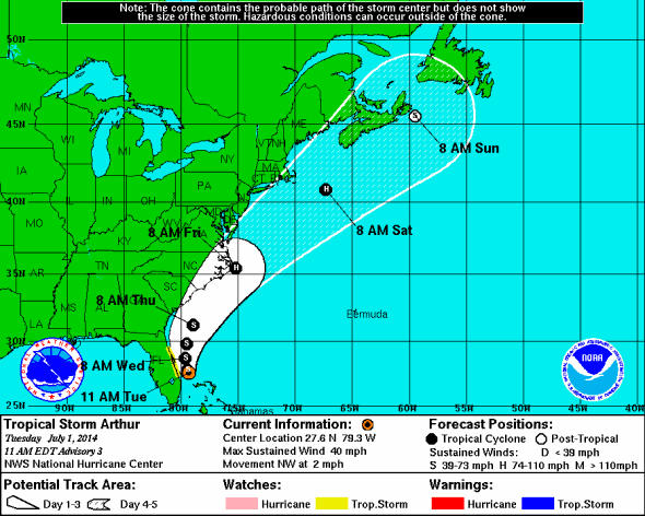
Image: National Hurricane Center
Much warmer than normal ocean temperatures will help fuel Arthur’s growth over the next few days, as the storm traverses the warm Gulf Stream current, leaving the potential for quick intensification beyond the official forecast. There’s much tighter than normal agreement among the weather models as far as the storm’s future track, though it’s still unclear whether Arthur’s center will pass directly over the North Carolina Outer Banks or stay slightly offshore.
If a hurricane does hit the Outer Banks this week, the timing couldn’t be worse. It’s peak tourist season, and the population of the chain of barrier islands has swelled from its normal 35,000 to likely more than 250,000. The only way to access the Outer Banks is by a single two-lane highway or by ferry. Should an evacuation become necessary, it may take 72 hours or so—exactly when the National Hurricane Center is currently forecasting landfall to occur. Last week, the Washington Post, profiled the intense political debate surrounding North Carolina’s attempts to officially downplay the global warming-induced sea level rise forecasts on the Outer Banks that threatens to worsen the impact of future hurricanes.
The only good news here is that Arthur will be moving relatively quickly when it makes its closest approach to North Carolina. The worst of the accompanying wind and rain should last no more than 12 hours. But when you’re talking about a hurricane brushing up against a barrier island, it’s storm surge that’s the biggest threat. Arthur will be the first big test of the National Hurricane Center’s new storm surge inundation graphics, which will help visualize potential coastal flooding in a more understandable and long anticipated way: feet of water above ground level.
As it approaches the Outer Banks the night of July 3, Arthur will be moving parallel to the coast, as did 2011’s Hurricane Irene, which washed out several parts of the coastal highway with an 8 to 10 foot surge. The same thing happened the next year with Hurricane Sandy. The difference between Arthur and those two storms is that they both happened in the fall when the tourist flow is waning.
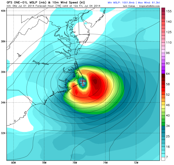
Graphic: NCEP/Levi Cowan
Timeline of what to expect:
Myrtle Beach, South Carolina (49 percent chance of tropical storm force winds, as of 11 a.m. Tuesday per the National Hurricane Center): On its current track, Arthur’s center should miss South Carolina, coming closest on Thursday afternoon (July 3). The worst case right now for Myrtle Beach is a brief brush with tropical storm force winds and heavy rain, something it should easily be able to handle.
Cape Hatteras, North Carolina (64 percent): The Outer Banks is where Arthur’s biggest impact will be felt. The storm’s center should pass very close, if not over the coastline, likely as a Category 1 hurricane during the early morning hours of July 4. The storm’s surge should cause coastal flooding, heavy rain, and sustained winds exceeding 70 mph, though these impacts may be relatively brief thanks to the storm’s relatively quick northward motion.
Ocean City, Maryland (29 percent): Maryland’s Eastern Shore may be brushed with tropical storm-force winds and rain on July 4, but the better chance is that the storm remains far enough offshore so that no great impacts are felt, other than heavy surf.
Atlantic City, New Jersey (19 percent): The New Jersey shore remains just on the edge of the National Hurricane Center’s forecast cone, though no current forecast model shows Arthur making landfall there. The storm’s closest approach will come around midday on the Fourth.
New York City (14 percent): The big coastal cities of Washington, Baltimore, Philadelphia, and New York City remain just outside the forecast cone, but are likely to receive occasional rain showers on the Fourth. Washington has a better chance than New York City of skies clearing out before sunset and fireworks time.
Nantucket, Massachusetts (32 percent): The National Hurricane Center is forecasting Arthur to remain at hurricane strength as it moves rapidly northeastward and transitions to an extratropical cyclone during the day on the Fourth. That means the storm’s strongest winds should remain on the east side, reducing the risk of significant impact on the Massachusetts Cape and Islands.
Boston (16 percent): Though Boston is the only major Northeast city remaining inside the official forecast cone, it’s very unlikely to receive much of an impact beyond possible rain showers the evening of the Fourth.
Atlantic Canada: On Saturday and Sunday, Arthur will transition to become fully extratropical, though could still pose a moderate wind, rain, and coastal flooding threat to Nova Scotia and Newfoundland.
An Air Force reserve hurricane hunter airplane will fly a reconnaissance mission into Tropical Storm Arthur on Tuesday afternoon to gauge its strength and provide additional data to help improve computer model forecasts.