El Niño Is Here

Photo by Ian Waldie/Getty Images
How will we know when El Niño arrives?
According to ocean temperatures, it probably already has.
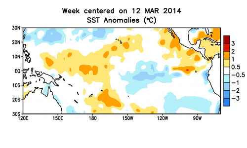
New data this week show that the water in a section of ocean called the Niño 3.4 region in the mid-Pacific has reached the +0.5 degree Celsius threshold typically used to define the start of an El Niño. That figure will have to persist or strengthen for the next six months (June to November) for an El Niño to be officially declared.
(Gif from NOAA.)
But the atmosphere hasn’t yet picked up the bait. For this El Niño to strengthen, the easterly trade winds will have to slow down. Once that happens, the upwelling of cold ocean water off the coast of South America is suppressed, and water temperatures at the surface will warm further, potentially unleashing a litany of effects across the globe.
New data from Australia’s Bureau of Meteorology for June show that while the warming ocean temperatures are revving toward El Niño, the Southern Oscillation Index—the atmospheric manifestation of El Niño and a proxy for the strength of the trade winds—is still firmly stuck in neutral.
The BOM has this insight into why:
Sea surface temperature (SST) anomalies in the tropical Pacific Ocean have increased steadily since February, and are now greater than +0.5 °C in the key NINO regions. However, above-average SSTs also extend into the western tropical Pacific, meaning strong west to east gradients in tropical Pacific SST anomalies are yet to become established. As a result, atmospheric indicators—such as the Southern Oscillation Index and trade winds—have only shown a weak response.
Still, according to BOM, Australia may already be feeling the effects of the new El Niño. May was hot and dry across the eastern part of the country.
Kevin Trenberth, a scientist at the National Center for Atmospheric Research who studies El Niño, told me in an email that we have essentially entered into a weak El Niño and it’s already changing our weather:
Yes, we are into El Niño of sorts but it has not yet taken off in a major way that suggests strong coupling between the atmosphere and ocean has set in. But then we don't usually expect this either at this time of year: the climatological sea surface temperatures are coldest about September and the trade winds strongest. It is after that we really expect it to take off setting the stage for next winter. What we can say is that conditions are such that we have a weak El Nino and the weather will already be quite different with respect to where tropical storms develop and move.
So, where does El Niño go from here?
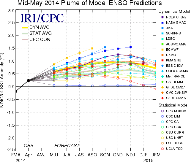
The most recent model-driven forecast of ocean temperatures by the International Research Institute for Climate and Society shows continued warming consistent with a moderate El Niño, peaking around the end of 2014.
To take into account the atmospheric components of the El Niño phenomenon, NOAA scientist Klaus Wolter helped create a more comprehensive assessment called the “Multivariate ENSO Index,” which combines wind speed and air pressure anomalies, cloudiness, and the more traditional measures of temperature across the tropical Pacific Ocean to determine whether an El Niño might be occurring and its relative strength.
In an analysis by Wolter taking into account all the years since 1950 that have had a similar MEI progression as 2014, eight out of the 10 closest matches eventually went on to become a full-fledged El Niño. Most notably, the 1997-1998 super El Niño was not among the historical analog cases.
It’s still too early to say just how strong this year’s El Niño will be, but its clock has already started: El Niño is here.
Update, June 5, 2014: Just after press time, Wolter updated his analysis for June. There remains an 80 percent chance for continued El Niño conditions for the rest of 2014, but the big El Niño of 1997-1998 is back among the clearest historical matches to current conditions. Wolter says the odds for a strong El Niño are perhaps slightly higher than before, somewhere around 60 percent, and cites additional evidence that the current El Niño will not fizzle like the last one in 2012. According to Wolter, "the long anticipated breakthrough to El Niño conditions in 2014 is clearly under way."
Future Tense is a partnership of Slate, New America, and Arizona State University.