It’s official: the current tornado outbreak is among the most severe of any two-day stretch in the past decade.
After an early season lull, Sunday was the deadliest tornado day since May 20, 2013, when an EF-5 tornado hit the Oklahoma City metro area. Sunday’s storms killed at least 16 people in Arkansas and Oklahoma, according to a Reuters report. There were 30 tornado reports in seven states on Sunday.
The ongoing tornado outbreak reached its second day on Monday, with live video from a local television station showing a large tornado approaching Tupelo, Miss.
A recent nationwide upgrade in National Weather Service radars has helped identify “debris ball” signatures such as the one in Tupelo today. The system can now systematically analyze tornado-producing clouds for objects lofted by strong winds that—unlike raindrops—aren’t round. The advance in technology has allowed forecasters to increase warning times for the most dangerous tornadoes.
A “tornado emergency” was issued by the National Weather Service in Memphis just before the tornado struck Tupelo. Those words are typically reserved for when a large tornado is headed for a heavily populated area. The same heightened language was used by forecasters in Arkansas yesterday.
Newscasters at WTVA in Tupelo evacuated the studio on live TV. One of the deadliest tornadoes in U.S. history struck Tupelo nearly 80 years ago, with one famous survivor:
The Storm Prediction Center has upgraded Monday’s continuing threat to “high risk,” emphasizing that “significant tornadoes are expected.”
This is only the sixth tornado outbreak in the past 10 years featuring back-to-back high risk outlooks from the Storm Prediction Center. Each previous outbreak of this magnitude has featured at least 50 tornadoes in a two-day span. The current outbreak has been exceptionally well forecast, with early indications of a particularly severe outbreak being shown by computer weather models and historical analogs for nearly a week now.
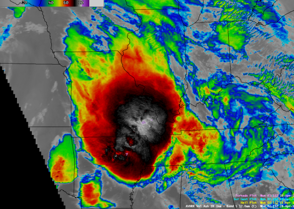
The image at the top was captured by a National Weather Service polar orbiting satellite on Sunday evening as deadly tornadoes hit parts of Arkansas. Polar orbiting satellites can provide exceptionally high-resolution pictures of storms, orbiting at about twice the altitude of the International Space Station.
More widely used geostationary satellites, on the other hand, orbit 40 times higher. The ability of geostationary weather satellites to see half the Earth in one clean shot helps to assemble stunning animations, like this one taken of yesterday’s storms.
Damage survey teams are in Arkansas today to assess the strength of yesterday’s tornadoes. The deadliest tornado yesterday—hitting Vilonia and Mayflower—will be rated at least EF-3, according to the local National Weather Service.
The persistent storms will also create a heightened flood risk, with nearly six inches of rain expected across the region.