Bet you thought winter was over, didn’t you? You even put away your cold-weather clothes, you poor optimist. Well, if you live anywhere east of, oh, say, Colorado, chances are you have a few more chilly nights ahead.
Now, it won’t be freeze-your-tongue-to-the-lightpole cold. But the effects of this winter’s repeated Arctic blasts are still lingering.
A significant multi-day severe weather outbreak is looking increasingly likely for this weekend. The powerful low pressure system associated with those storms will push temperatures up into the 80s (or even 90s) across much of the south until Monday or Tuesday.
After the storm system slowly moves through, blocked in place by an impressive blob of high pressure over Canada, a sharp north-to-south elongation of the jet stream will usher in some seriously frigid weather. The first week of May is looking decidedly unspringlike, especially for the Gulf Coast. Low temperatures on May 1st could be in the 30s from Dallas to Birmingham—challenging hundred-year-old record lows—with cold weather of nearly that magnitude spreading to the East Coast by next weekend.
There’s even a (slim) chance of snow as far south as St. Louis, Chicago, Detroit, and Boston next week. There hasn’t been measurable snowfall in St. Louis in May since 1929.
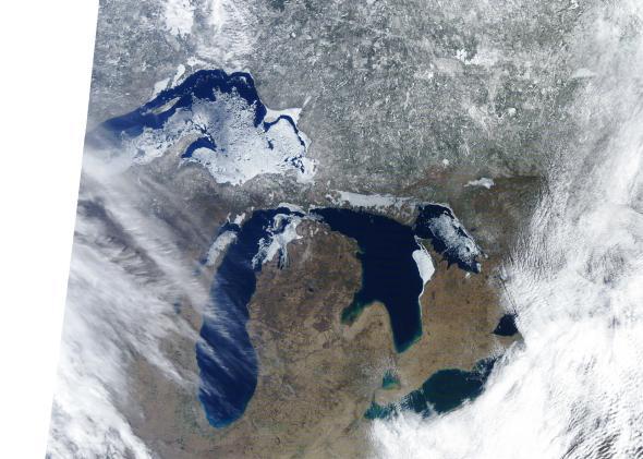
Meanwhile, a record-breaking amount of ice is hanging on over at the Great Lakes—by far the most ice that’s remained this late in the season in at least 30 years.
The incredible amount of ice that formed this winter is a symptom of a persistent weather pattern that could linger across the East deep into the summer months, according to an analysis by the Washington Post’s Capital Weather Gang:
[A]s this region represents but a tiny fraction of North America, its direct effect on temperatures won’t extend far. Yet the overarching weather pattern responsible for those icy waters to begin with may show considerable staying power.
That’s to say, Great Lakes ice is somewhat of a canary in the coal mine, signaling a weather pattern that could be locked in for the long haul. But don’t take all your anger out on the ice just yet. It may fight back. Actually, it already has.
Weather Underground explains:
An ice shove is a rapid push of free-floating lake or sea ice onshore by wind. Strong winds from the same direction over, say, a 12 to 24 hour period, are enough to drive large chunks and plates of ice ashore.
The initial slabs or blocks of ice will slow down momentarily when reaching land, creating a traffic jam of ice piling behind and on top. The result is a massive ice pile often over 10 feet high, surging ashore in a matter of minutes, surrounding and damaging everything in their path, including trees, sod, fences, and homes.
In some parts of the Great Lakes, Upper Midwest and Canada, ice shoves are common in the spring as lake ice breaks up, floats, then push ashore. April and May are considered ice shove season along Wisconsin’s Lake Winnebago shore.
An impressive string of ice shoves were documented in spring 2013, including a destructive event along the southwest shore of Manitoba’s Dauphin Lake on May 10, damaging 27 homes near Ochre Beach.
While this year’s ice shoves weren’t as damaging as last year’s, they were still impressive.
Like this one in Wisconsin:
Or this one in Ohio:
Or this one in Vermont:
Or this one in Michigan:
But buck up, would-be campers. A quick-developing El Niño may also help put an anchor on summer temperatures in the East. Come late July, you may be longing for a little of that ice.