Hey, East Coast, a “Nor’easter Bomb” Might Be Heading Your Way

Photo by KAREN BLEIER/AFP/Getty Images
Though the calendar now says spring, atmospheric gremlins are conspiring to make winter linger a bit longer.
Thanks to a Rex Block over Alaska, the jet stream will take another deep dive from the North Pole to the eastern United States this weekend. That pattern will be locked in place throughout much of next week, plunging most of the eastern part of the country back into the deep freeze. Temperatures from Sunday to Thursday will be 10 to 25 degrees colder than long-term averages across most of the East, more fitting of mid-January than late March.
But the crown jewel of the wintery encore will be a major late-season nor’easter. Born of a combination of bitterly cold air and a core of rapidly intensifying low pressure, a big storm is increasingly likely to buzz the East Coast early next week.
The National Weather Service did not mince words in their headline of a technical discussion of the potential beast: “Nor'easter bomb indicated off the mid-Atlantic coast late Tuesday night.”
The scary-sounding descriptor “bomb”—also known as “explosive cyclogenesis”–is a technical word meteorologists use when low pressure centers deepen at a rate faster than 24 millibars in 24 hours, which happens in only the most intense storms.
The NWS continues:
The East Coast cyclone has the potential to produce late-season heavy snowfall over a wide swath of real estate from Virginia to New England; that is a generality at this point. Much remains in terms of refining the forecast state by state. Another high-impact factor will be the powerful winds generated by this sprawling, intense circulation, along with high seas, beach battery, coastal flooding, and so forth. Again, at this point, such sensible weather effects are simply attendant to the potential of such a storm.
That’s a bold forecast, especially five days before the storm arrives.
In this case, however, forecasting an extreme storm next week is becoming an increasingly easy call. Weather models have been showing the possibility of a big storm for days now and are displaying the kind of consistency meteorologists look for before going out on a limb.
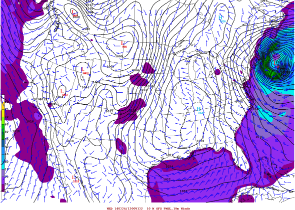
In fact, one particular model, the GFS—the best long-range model produced by the United States—is forecasting the storm to strengthen at more than twice the rate necessary for a bomb, from 995 millibars Tuesday evening off the North Carolina coast to 968 millibars Wednesday morning off Long Island, just 12 hours later. That same model is forecasting the storm to peak with sustained surface winds of hurricane force over the ocean by Wednesday afternoon. At that same time, in the jet stream well above the surface, winds are expected to top 170 mph—fueling the rapid growth of the storm and increasing its “bomb”-making potential.

Map of 00z GFS surface winds, via americanwx.com
The extremely strong jet stream will form a direct link between the Arctic and the East Coast, energizing the storm and turning it into a major snow producer.
While the National Weather Service is understandably skittish about making snowfall predictions when the storm is still five days away, thanks to the wonders of technology, we can get a sneak peak of what the totals might be.
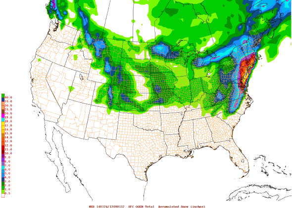
Another model, the GGEM (created by the Canadian Meteorological Centre), has a snow forecast that would rank as one of the biggest the New York City area has ever seen—more than two feet by Wednesday.
Now, the GGEM is more than likely wrong—the New York City office of the National Weather service conservatively noted the double-barreled center the GGEM is currently showing is probably unrealistic—but barring big changes in the forecast, there’s an increasingly strong line of evidence that someone’s going to get walloped on that order somewhere along the East Coast.

Map of 00z GGEM model, via americanwx.com
The Cooperative Institute for Precipitation Systems at Saint Louis University has applied a pattern-recognition algorithm to a compendium of 6-hourly weather maps for the last 30+ years. The top 15 hits for next week’s storm, when averaged together, produced a snow map from Georgia to New England with a reasonable six inches or snow from roughly Washington, D.C., to NYC to Boston.
It’s important to note that the CIPS result isn’t technically a forecast: It’s an average of historical storms that are strongly correlated with the current forecast. The analog method is a pretty straightforward big-data way of tackling a tough forecast, and answers the question: "Of the historical weather maps that look the most like the current one, what happened afterwards?" Many of the storms in this CIPS map produced less than six inches of snow, a few produced much more. And one of those matches was a doozy.
As I mentioned Wednesday, one of the top analogs from NOAA’s Climate Prediction Center for next week’s weather remains the Superstorm of 1993, one of the biggest March blizzards of all time. According to a National Weather Service archive, that storm brought hurricane force winds and all-time low pressure records (which still stand today) to parts of the South and dropped an astounding 13 cubic miles of snow from Florida to Maine. Simply put: It was one of the most extreme late-season winter storms in U.S. history.
Here’s the Weather Channel’s coverage of the 1993 Superstorm:
Now, to forecast a historic storm five days in advance would be premature. All we really know right now is there will be a storm, and it’s probably going to be big.
In an earlier weather discussion, the National Weather Service cautioned that despite the strong signal the weather models are showing, the storm is still so far out in time that chaos theory dictates that small changes now could lead to big shifts in the forecast down the road. In fact, part of the atmospheric energy that is expected to become the East Coast storm down the line is still over the Gulf of Alaska and won’t make landfall in British Columbia—where it can be better sampled by weather stations—until Sunday. The Rex Block complicates things further and could potentially siphon off a bit of the energy before it ever reaches shore. By Sunday evening, weather models should have ingested these critical datapoints and forecast reliability should improve. If the storm is still showing up then, buckle up.
Future Tense is a partnership of Slate, New America, and Arizona State University.
