Someday soon, I’m sure DARPA’s BigDog will mate with a salamander robot and produce some artificial intelligence that either enslaves the human race or is really, really needy. Until such a time, there remain yet a few jobs that will someday be perfect for machines but that only we dashing humans can do now—like mapping underground tunnels seething with radiation or the cargo hulls of ships chockfull of bombs. (I didn’t say they were good jobs.) That’s why researchers at the Johns Hopkins University Applied Physics Laboratory have created a condensed, map-tastic backpack system for gathering intel on environmental threats in tough spots.*
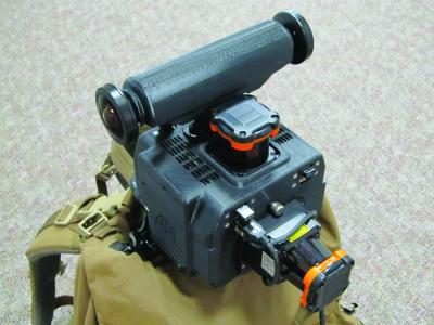
Right away, this sounds like a job for the Google Maps team—presuming they’re back from Everest Base Camp—but the APL’s backpack mapper has to do a great deal more than stitch pictures together. In fact, the Enhanced Mapping and Positioning System uses light, detection, and ranging (LIDAR) sensors to generate what the press release calls “a floor-plan-style map of the area traversed.”
Among the array of LIDAR sensors is a 270-degree laser scanner that can measure distances to walls, ceilings, or other features in the environment like sleeping subterranean lizards the size of skyscrapers. Add-ons to the base model include a second laser scanner for 3-D data collection, a camera system to snap omnidirectional images along the walker’s path, and a GPS receiver for georegistration of data. Everything fits neatly in a six-inch cube that weighs less than four pounds and is said to be smaller than a brick.
“EMAPS virtually takes pictures with every step,” says Jason Stipes in the press release. Stipes works for the APL’s Force Projection Department. “Using this technology, we can map almost every nook and cranny of targeted locations, capture that intelligence, and store it. Sensors can also detect threats, such as radiation or chemicals, and include them in our map.”
The project was produced for the Defense Threat Reduction Agency, a name that calls to mind Nick Fury’s S.H.I.E.L.D. In reality, the DTRA is the U.S. Department of Defense’s official Combat Support Agency for countering weapons of mass destruction.
The EMAPS backpack has already been tested in diverse GPS-denied environments, including ships, underground storage facilities, and Army training areas. They’ve even let it loose in the Smithsonian Natural History Museum. (Rumor has it Ben Stiller’s working on a script.)
The system can take into account the pitch, roll, and yaw of human locomotion. To do this, researchers improved upon algorithms once developed for robots. (Jeez, robots, do we have to do everything for you?)
It’s not difficult to see why the DTRA would be interested in an extremely detailed map capable of pinpointing everything from the distance between exits to radio frequency signal levels. (Homemade IEDs and roadside bombs can be remotely detonated by transmitting a radio frequency signal.) I just wonder how long it will be before robot navigation catches up to the point where this technology is implemented for the next generation of bat-winged, cinderblock-throwing, death-gripping snake drones.
Correction, March 28, 2013: This blog post originally misidentified Johns Hopkins University as John Hopkins University.