The fourth entry in an occasional series examining mysterious or overlooked objects in our visual landscape. If you would like to suggest an object for the series, see the email address provided at the bottom of this post.
In our quest to dispel some of the mysteries of the constructed environment, we’ve recently been looking up at mysterious wires and strange streetlight imposters. This week, we lower our gaze.
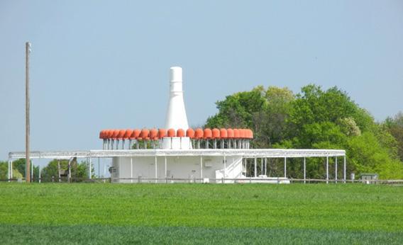
What’s that out in the field over there? Donna and Paul Hirsch encountered the strange construction in the photo above on a visit to their niece and her family in Greensboro, N.C. Mrs. Hirsch first wondered if the device might be agricultural, given the numerous nearby farms. She also thought it might have a purpose on the other end of the technology spectrum: Perhaps it was related to the many new-economy businesses in the Greensboro area. Go on, have a look from above.
As it happens, there are quite a few of these doodads scattered across the landscape. You may have seen one yourself, on a road trip through the middle of nowhere, perhaps—or in a well-developed area like Greensboro. But what is it?
As always, your four options:
a) It’s a GPS calibration device. These are scattered around the U.S. (but not overseas—GPS remains a U.S. military system). To continually refine the accuracy of GPS signals, calibration devices like this—basically, giant, hyper-accurate GPS receivers—constantly compare their GPS-computed position with their known location.
b) It’s a navigation beacon for aircraft. It sends out signals that tell aircraft their bearing from the beacon, and their distance, and allows planes to ‘see’ where they are in any weather, even in the absence of GPS or ground-based radar.
c) Remember Jodie Foster, Matthew McConaughey, and the Very Large Array of radio antennas in the movie Contact? This is part of another, less photogenic deep-space radio project. The signals from these sensors—there are nearly 300 across the country—are mathematically pooled together to create a virtual, continent-sized radio telescope.
d) No one knows what these are—or rather, those who do won’t tell us. These sites, which were built after 9/11, are controlled by the Departments of Defense and Homeland Security, which will not release information about their purpose, other than that they do not produce “harmful radiation or interference.”
And the answer is…
…b). The device pictured is a navigation beacon called a VOR, which stands for Very High Frequency Omnidirectional Radio Range. It tells a pilot (or her on-board computer) her direction from the beacon, using frequencies only just slightly above those used by the FM radio stations we listen to every day. And while it may look high-tech, VORs are relatively ancient, first coming into use after World War II.
How’s it work? A VOR transmits two radio signals: a master signal, and a secondary signal. The master signal is broadcast in every direction, while the secondary signal is rotated (originally, the antenna was literally spun, now it’s “turned” electronically). The phases of the two signals—that is, the crests and troughs of the radio waves—are aligned once per rotation, at due north. The rest of the time the phase difference between the two varies through 360 degrees, and thus indicates your direction from the beacon. There are different kinds of VORs in use, but that’s the general principle.
VORs are usually co-located with another device (called a DME) that gives distance from the beacon: the aircraft sends out “hello” calls, and the DME answers back—at a known delay after hearing the hello. Since the aircraft knows that fixed delay, any additional delay must be due to the distance between the aircraft and the beacon. A combined VOR-DME can tell a pilot both their direction and their distance from a beacon—very useful information on a dark, cloudy night. (Here’s some technical detail on VORs—and a helpful video user’s guide.)
Airplanes generally fly along airways, the virtual highways in the sky. For many years, these airways were laid out on charts as lines between VORs, so that pilots could fly from one beacon to the next, all the way across the country. That’s why you’re as likely to spot a VOR on a drive through the middle of nowhere as you are at or near an airport. Most of the roughly 1000 VORs operating in the U.S. today will be retired by 2025, according to Ian Gregor, an FAA spokesman. He noted that VORs themselves replaced visual navigation beacons—including bonfires back in aviation’s earliest days—and that, for the aviation enthusiast who has everything, a new VOR will run you about $500,000.
To find the VOR nearest you, go to SkyVector, and enter the three-letter code for your nearest airport in the box at top-left. You can identify nearby VORs by their hexagonal symbols, surrounded by a larger circle that’s marked out like a clockface without numbers. Each VOR has an explanatory box with a name, a frequency, a Morse code identifier, and the beacon’s latitude and longitude.
To find the VOR nearest you, go to SkyVector, and enter the three-letter code for your nearest airport in the box at top-left. You can identify nearby VORs by their hexagonal symbols, surrounded by a larger circle that’s marked out like a clockface without numbers. Each VOR has an explanatory box with a name, a frequency, a Morse code identifier, and the beacon’s latitude and longitude.
For more high-altitude fun on the SkyVector site, select “Sectional” under “Charts,” and click on your home region to browse these stunningly beautiful maps. For a higher but less colorful vantage point, select “Enroute High,” and you can track the skyways, from VOR to VOR, that make up America’s original airborne interstates.
Detail of a SkyVector map of the area around New York City
Something else you’ve wondered about, high in the sky or hiding in plain sight in a nearby field? Send a pic and a brief description to whatisthat@markvr.com.
Previous editions of What’s That Thing?
Ominous Gizmo
Dashboard Arrow
Mysterious Wires