What the heck kind of cloud formations are these?
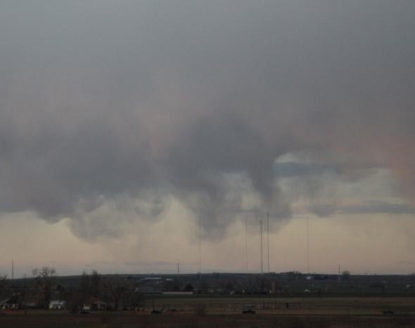
I saw this unusual cloud pattern coming home from the Denver airport. We were driving almost due west, and I was looking out the passenger window, toward the north. It was April 3, 2014, just after 7 p.m. local time. There was a low cloud deck, and the clouds were moving pretty briskly to the east (left to right in all the pictures), even accounting for our own car’s motion westward. The Sun was just over the mountains to the west and provided some color and interesting contrast to what I was seeing. I’m not sure how far away they were, but I’m guessing 10 kilometers or so.
The “fingers” dropping down are clearly the result of downdrafts; I could see them moving downward as I watched. Downdrafts can form at the bottoms of clouds as water in the air evaporates. It absorbs heat from the air, and as the airs cools from that it starts to descend. This happens often, but I’ve never seen it as well organized as in these clouds. The air is falling in focused individual columns that retained their shape for quite some time. As they fell, many formed well-defined “heads” at the bottom, like an upside-down mushroom, and had long “stems”.
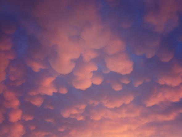
Photo by Shutterstock/Aleksandra Aleksandrova
This type of phenomenon is due to what’s called the Rayleigh-Taylor instability, when you have a dense fluid on top of a less dense one. The system is quasi-stable; it’ll stay that way if it’s not disturbed. But poke it and the denser fluid will fall, creating multiple fingers as it pushes through the fluid below it (here’s a great example you can try at home). When I was in grad school, we had to solve the fluid equations for this; it was actually only two pages of complicated algebra, a lot fewer than I would have guessed!
The clouds were fascinating. The downdrafts never seemed to reach the ground; they would fall apart (“lose their organization” is what a physicist would say) before they could impact the surface. In general, if the downdrafts are strong enough they can reach the ground. Sometimes they do so with a lot of force, causing what are called microbursts with sometimes devastating results. The one I saw didn’t have nearly that kind of energy, though.
Also, in every photo it seems like we’re seeing a timeline snapshot of their evolution. Remember, the clouds are moving to the east (left to right). The downdrafts were forming roughly around the same spot over the ground, then apparently dropping lower with time. So in these photos you tend to see shorter fingers on the left, longer on the right, and then they would fall apart on the extreme right. I’m not sure why they formed at the same spot as the cloud moved over the land, but it may have been due to wind shear or turbulence at some spot due to the land topography. When the cloud passed over that spot, it triggered the instability. But I’m really just guessing here, and I can’t be 100 percent sure this is what’s really going on.
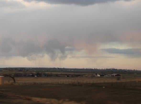
Photo by Phil Plait
Either way, these are definitely well-organized and focused downdrafts. I was curious as to whether this type of phenomenon had a special name, so I could look into it more. I wanted answers! So I turned to Twitter to crowdsource the problem. I got a lot of replies, some of which didn’t seem quite right but led to interesting diversions (like finding out about fractus clouds, also called scud clouds). A lot of people suggested I was seeing virga—condensing water that falls from clouds but evaporates before hitting the ground—and I do think that’s a part of this. But a virga usually falls in sheets and looks feathery, while this was clearly more organized. And the repeating pattern was pretty trippy.
Some people suggested these were mammatus clouds, bulb-shaped appendages (think about the root word for “mammatus”) that are sometimes seen on the edges of storms. I wondered about that—I saw them once before a hurricane hit Maryland years ago, forming a big loose grid like in the image above, though they don’t have to be laid out that way.
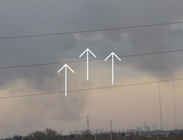
Photo by Phil Plait
I’ve never heard of mammatus clouds erupting downward like these fingers did, however. Still, as you can see in the photo above (where I’ve added arrows), there do appear to be some bulb-like features. They’re faint and hard to see, and I can’t tell if these are proto-mammatus features or not. It’s possible that the finger are related to mammatus clouds, but somehow managed to keep descending, stretching out longer than you usually see.
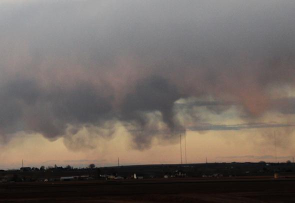
Photo by Phil Plait
The setting Sun helped a bit, throwing some of the fingers into shadow while lighting others up (in a lovely pink hue), but it also made it hard to get much depth on individual fingers. For a while I thought they were in rows, but that’s most likely an illusion caused by the way they’re lit. Some of them looked enough like funnel clouds dropping down that when I first saw them I had a fun moment (if by fun you mean “holy crap let’s get the heck OUT OF HERE”), but there was no rotation, and as we got closer, it was clear these were not nascent tornadoes.
Since no one seemed to have a specific name for these types of cloud formations, I’m going to stick with “cloud fingers.” If it turns out there really is no designation for them, I reserve the right to call them “philanges.” That has a nice ring to it.
For someone like me who finds endless fascination with clouds, Boulder, Colorado, is a great place to live. The mountains provide all manners of interesting mechanisms to drive cloud formation, and we get incredible sights like iridescence, lenticular clouds, fist clouds (not an official name, but c’mon, what would you call this?), pyrocumulus (sadly), ridiculously complex festoons and whorls, standing edges (air rising over the mountains cools and water condenses, forming clouds in a loooong line that runs roughly north/south along the mountain range; the cloud edge appears to just sit there, sometimes for days. It’s like a traffic jam where cars move in and out but the jam persists), and more.
And then, more often than not, when the Sun sets the clouds go away, and I’m faced with clear skies. Then I can turn to my most favorite thing to do, of course. But in both cases, the initial impetus is the same: Look up!
There is amazing stuff up there.