As I write this, a massive storm is inflicting itself upon the Philippines: super typhoon Haiyan. A typhoon is what hurricanes are called in the northwest Pacific Ocean, so you can guess what a super typhoon will be like.
This typhoon is beyond huge: It’s roughly 2000 kilometers (1200 miles) across, and the power of it is terrifying. The sustained winds have been clocked at 310 kilometers per hour (195 miles per hour) and has gusts topping 380 kph (235 mph)! It is sure to cause vast amounts of damage to the island nation, and there is no doubt many lives will be lost.
And yet…from space, the storm is awe-inspiring.
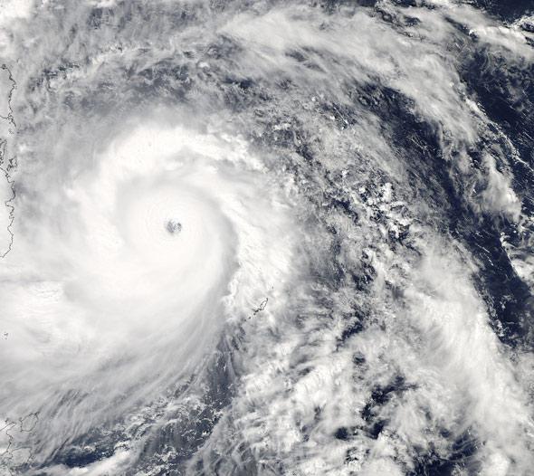
Photo by NASA / Aqua
That is an image from NASA’s Aqua satellite, an Earth-observing platform that is specifically designed to observe our planet’s water cycle. That shot was taken on Nov. 7, 2013 at 04:25 UTC (afternoon local time). The eye of the typhoon is strong, and the feeder bands sweep out over a tremendous distance. From Aqua’s viewpoint in orbit, 700 km (430 miles) up, the terrible nature of this storm is not so immediate, amplifying its grace and symmetry. The high-resolution version is jaw-dropping; what I’ve shown here is a small piece of a much larger picture.
Another view from space puts the storm in context:
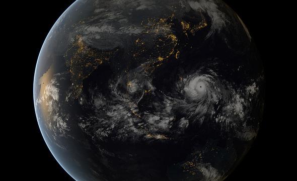
Photo by Japan Meteorological Agency and EUMETSAT
That is a combination of images from Japanese and European weather satellites, also on Nov. 7, 2013, at 13:00 UTC, around local midnight. These satellites are in geostationary orbits, 36,000 km (22,000 miles) above the Earth’s surface, and provide a much broader view. You can see Haiyan to the right, the city lights of the Philippines almost underneath it. Lights from China, Thailand, Malaysia, Indonesia and India are to the west, and Australia is far to the south. The brassy glow on the left is sunset over the Arabian Sea and the east coast of Africa, Oman, and Yemen. Again, look at the high-resolution version; the beauty of this sort of picture is astonishing.
But do not be fooled. Haiyan is a monster, one of the strongest storms ever recorded in modern history. There is no way this will end well.
For more information, I suggest keeping up with Jeff Masters blog at Wunderground, and the Capital Weather Gang at the Washington Post. The latter has an excellent description of what’s going on, including precisely why this storm is so dangerous - a three meter storm surge of water, tremendous winds, and heavy rain. Also, it is expected to pass very close to two densely populated cities, Cebu and Tacloban.
I hope for the best with Haiyan, but having been in a few hurricanes, I know how bad this can be. As I fret over this event, I try to keep in mind how much worse it would be if we didn’t have the engineering and technology to study these massive storm systems, learn from them, and be able to predict them and their behavior. Many, many lives are saved every year by weather forecasting, and perhaps someday we’ll be in a position to save even more. For now, though, we’ll have to wait and see how this particular storm plays out.
[Correction (Nov. 7, 2013 at 22:20 UTC): I initially wrote that a typhoon is what a hurricane is called in the southern hemisphere. Actually, typhoons are in the Pacific as opposed to the Atlantic ocean. I also wrote that the typhoon was about to inflict itself on the Philippines; I meant the eye of the storm, but the feeder bands have been lashing the islands for some time already.]