On May 31, just before 9:00 a.m. local time, the International Space Station was passing over the small island of Gaua in the south Pacific. Well, small as seen from above the ocean; it’s actually a massive stratovolcano more than 3,000 meters (2 miles) tall from base to tip and 40 kilometers across.
But only the very top of it pokes above the water. Still, it provides a dramatic view from 420 kilometers (250 miles) above the Earth:
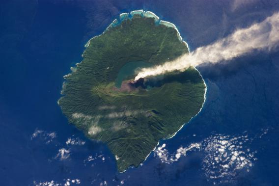
Photo by NASA
This was taken by an astronaut on ISS, looking not too far from straight down on the volcano. The peak of the volcano is called Gharat, and you can see the obvious and perfectly formed plume made primarily of steam blowing from it to the east. The volcano is active and had been blowing out steam for about a month before this photo was taken.
I like how beautifully framed this picture is and how textbook the volcanic peak is. Gharat rises to about 800 meters above sea level, and has the lovely semicircular Lake Letas to the north and east. (I have to note that “Gharat” sounds Cardassian, and “Letas” Bajoran; perhaps I am simply too big a Star Trek dork.) The island, populated by 2,500 people, is the biggest in the Banks Islands group in the Republic of Vanuatu, east of northern Australia. These are all volcanic islands, though not all currently active.
I would wager a healthy sum that most people have never heard of this tiny island. I know a little about Vanuatu, but mostly because I’m fascinated by both volcanoes and pictures of them from space, so I’ve read about it before. This is a great reminder that we live on a huge planet, so spread out, that there are actually parts of it you weren’t even aware of. How much of Earth don’t you know? How much more is there for any of us to explore and discover? We all live here, after all. Shouldn’t we take the time to learn more about our home?