On May 20, 2013, a huge tornado wreaked havoc on Moore, Oklahoma, tearing right through the town. It was rated an EF5, the highest possible, with 340 km/hr (210 mile/hour) winds. Two dozen people lost their lives, hundreds were injured, and thousands of buildings sustained damage—from minor problems to complete razing.
Two weeks later, from high above, the Terra Earth-observing satellite peered down at the region and took this picture showing just how laser-focused the tornado was:
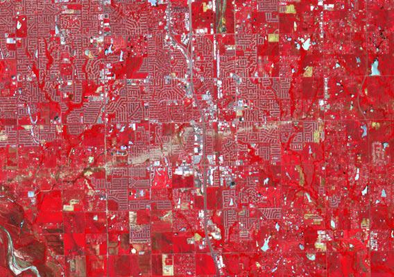
Photo by NASA Earth Observatory
The image shows an area about 15 kilometers (9 miles) wide. It’s false color, combining visible and infrared light to highlight various aspects of the terrain. Red shows vegetation (which is highly reflective in the infrared), blue water, and bluish-gray roads and buildings. The track of the tornado is obvious; the color is due to the lack of vegetation which was ripped up by the fierce winds. The path extends down and to the left, beyond the frame of this image (though you can see the whole thing in the full-size image); the tornado was ultimately on the ground for a length of 27 kilometers (17 miles).
The tornado path can be seen easily from the ground, of course, but an overview like this helps pinpoint the size and scope of the event. Also, not every tornado goes through a populated area where the eventual path can be easily mapped. Data like this, combined with “ground truth” and other satellite observations, help meteorologists understand the formation and behavior of tornadoes and other violent weather events. [As an aside, the European Proba-V satellite recently started observing the Earth, specifically looking at vegetation patterns.]
The personal scope of this event is difficult to understand if you’ve never experienced it; I’ll admit I haven’t, though I’ve had my share of terrifying moments in various hurricanes. But I’m glad we have so many means to study tornadoes, including satellites capable of observations like this. We may never be able to control the weather, or prevent tornadoes from forming, but in disasters like this, seconds count. The more lead-time we can give people that it’s headed their way (and the better we can communicate to them), the better.