The storms that swept through Oklahoma yesterday left astonishing devastation in their wake. The live video and photos taken from the ground are horrifying, grim, and heart-breaking.
Whenever there is some sort of terrible weather event, one of the first things I do is check the satellite imagery to see what the system looks like, and how wide-spread it is. And every time, I forget how different things look from space. The contrast is shocking, even when you expect it.
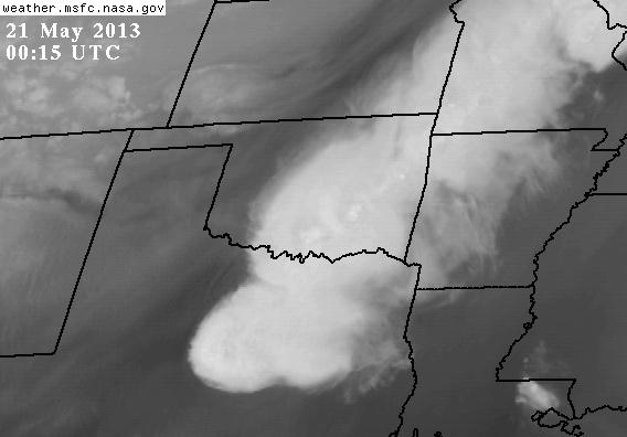
Photo by NOAA/GOES/Earth Science Office in Huntsville, Alabama.
That’s a Geostationary Operational Environmental Satellite (GOES) infrared image of the Oklahoma area taken on May 21, 2013 at 00:15 UTC (May 20 at 7:15 p.m. local time), shortly after the region was being slammed by a monstrous tornado. This wavelength of light emphasizes water vapor at an altitude of about 6 – 10 kilometers (4 – 6 miles), and is a good tracer of high-elevation winds, the jet stream, and of course storm activity.
Photo by NOAA/GOES/National Weather Service
From this height—the GOES satellites orbit at 35,800 km (22,300 miles) above the Earth’s surface—the terrible effects of this violent system are not only invisible, but replaced with a kind of serene and delicate-looking beauty that is one of the biggest ironies of which I know. It’s even more so for hurricanes, which possess a symmetry and frightening majesty.
[Update (May 21, 2013 at 15:30 UTC): The MODIS instrument on NASA’s Aqua Earth-observing satellite took this much higher-resolution visible-light image at 19:40 UTC, just as the tornado was getting started.
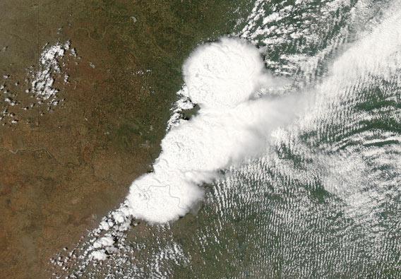
Photo by NASA/GSFC/Jeff Schmaltz/MODIS Land Rapid Response Team
The full-resolution version makes the case for the contrast between horror and beauty even more vivid.]
Satellite images like these have been and still are helping meteorologists get a better handle on dangerous weather, and even though it is not yet an exact science, it’s far better than it once was, and will get better yet. I hope that there will come a day when we will know precisely where and when violent weather will hit, and be able to give people enough time to seek shelter so that tragedies like yesterday will be avoided.
My heart goes out to all those affected by this weather. If you want to help, the Take Part website has a list of organizations that are in the area giving support.
Thanks to my friend Jessica for the link to Take Part.