Chris Hadfield is an astronaut on board the International Space Station. He just officially became commander, in fact, as the crew transitioned from Expedition 34 to 35, and the three crewmembers from 34 returned to Earth.
Hadfield takes fantastic pictures of Earth from the ISS and tweets them. On Saturday, Mar. 16, he posted this picture of a volcano, with a simple caption: “Peekaboo volcano.”
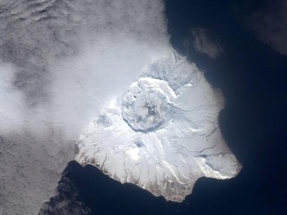
Image credit: NASA
I chuckled; the picture is beautiful, with what’s clearly a volcanic island half hidden below a line of clouds.
But then I wondered, what volcano is that? It’s covered in snow, so it’s pretty far north, but where? Japan, Russian, Alaska?
So I tweeted back: “Wow! Do you have an ID on that island volcano? I’d love to write about it…” I wasn’t necessarily expecting a reply, but within minutes I got a reply from Evan Hadfield, Commander Hadfield’s son who keeps track of his father’s doings. He said it was in the Aleutian islands (Alaska then!) and gave a set of coordinates.
I checked Google maps, but saw nothing but open water there. Hmmm. Evan and I went back and forth on it, with me scanning over the Aleutians looking for a positive ID. He wasn’t sure of the exact location because all he can get is the time the picture was taken, and the ISS position at that time. Looking down from space gives you a view of several million square kilometers, so narrowing that down can be, um, a bit tough.
But then the internet swooped down in the form of KJ Irwin:
A quick check in Wikipedia, and boom! Done. [I asked KJ how on Earth he could recognize it, and he replied, “When I’m not looking at the sky I’m a volcano enthusiast”, so there you go; being a science junkie pays off.]
The picture most certainly shows Mount Okmok, a shield volcano on the island of Umnak, one of the Fox Islands in the Aleutians. To give you a sense of scale the caldera is about 9 km (6 miles) across, and is actually comprised of two heavily overlapping calderas. The volcano looks peaceful enough, but don’t be fooled: in 2008 it erupted explosively, blasting a huge plume 15 km (9 miles) into the sky. The eruption was pretty big, and lasted for weeks. It was even seen by a GOES weather satellite:
The caldera used to house a lake 150 meters deep, but that drained away long ago when a notch in the northeast rim formed. In the image from space you can see that notch on the right side of the crater. The volcano has certainly had an interesting history; there are dozens of layers of tephra (a general term for fragmented volcanic rock) over the main layer forming the volcano. The main caldera is only about 12,000 years old, so this volcano erupts on average every couple of hundred years.
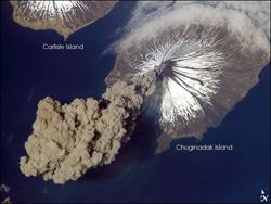
Image credit: NASA
Amazing. I knew the Aleutians were volcanic (I wrote about the 2006 eruption of the Cleveland volcano, which was actually first spotted by ISS astronauts), but I didn’t realize how many there were: There are nearly 70 volcanic islands in the archipelago!
I stand in awe of our planet. It’s so huge, so incredible, and there are just so many things to know about it. A dozen lifetimes wouldn’t be enough to appreciate our world. And it’s only one of billions in our galaxy alone. Billions.
Science! Overloading your brain with pure awesome for 500 years.