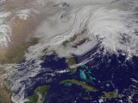
If you live on the east coast of the United States, then you might want to be ready for a little weather. This is what’s about to sweep over you:

Image credit: NASA
By now everyone in the affected area will have heard about this massive nor’easter. These are created when a low-pressure system forms in the south, usually in the Gulf of Mexico, bringing warm moist air north. If a cold front drops down from the north, the two can meet and cause rapidly forming nasty weather. In this case, the front stretches for thousands of kilometers, and practically the entire east coast will be affected one way or another.
The image above was taken at 09:01 Eastern time Friday morning (Feb. 8, 2013) by the NASA/NOAA GOES 13 weather satellite. At that time, the eastward-moving cold front from the northwest was just about to meet and merge with the counter-clockwise spinning warm low pressure system from the south, forming a proper nor’easter. The detail in the high-res version is stunning, and as always I have to marvel at how incredibly beautiful dangerous weather can look from space.
But there is more than eerie beauty here. As I write this, the picture was taken mere hours earlier, and was in the hands of meteorologists within minutes of being snapped. Such rapid response is critical for real-time updates of storm systems, and that can mean saved lives and prevention of property damage.
If anyone ever asks what space exploration has done for them, point them to this picture. The better we get at being in space, the better it is for everyone.