The folks in the northern Midwest and on the east coast are currently suffering under a massive cold snap. Temperatures dropping way below freezing are everywhere, and near the Great Lakes temperatures near -20° Celsius (0°F) have been recorded for days on end. The wind has been blowing as well, bringing the wind chill temperatures to truly cruel levels.
But in misery there can also be beauty. When you look down from orbit on such cold and windy days, just look what you can see:
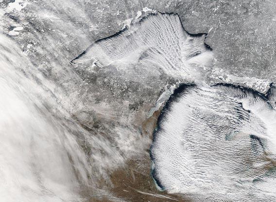
Image credit: NASA/Aqua
That spectacular image was taken around noon on Jan. 22, 2013 by NASA’s Earth-observing Aqua satellite. It shows Lake Superior to the upper left, Lake Michigan to the lower right, and part of Lake Huron to the right. This is one part of a much larger image; click it to see it in higher resolution, or grab the huge 5200 x 6000 pixel version, which shows the area at a resolution of 250 (820 feet) meters per pixel.
Most people would call these “lake effect” clouds, which is true enough. Dry, frigid air from the west blows over the relatively warmer waters, picks up water vapor and freezes it, then dumps it downwind. The lakes are unusually warm right now, so the effect is magnified. Folks downwind from the lakes can get huge amounts of snow; I heard that one place in New York (east of Lake Ontario) got 0.8 meters (32 inches) of snow from this latest storm in one day!
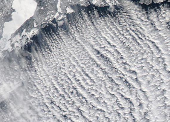
Image credit: NASA/Aqua
But what got my attention were the long, parallel streamers of clouds. These fascinating and beautiful structures are nicknamed “cloud streets” for obvious reasons. They are more technically called horizontal convection rolls. They are actually not terribly well understood, but we do know the basics.
What happens is that the cold dry air is coming in from the west and picks up moisture, as I described above. The air over the warmer lakes is rising, though. The cold air is blowing above it, acting like a lid to the rising warm, moist air. The rising air is stopped, and flows around to either side (imagine a plume of, say, cigarette smoke hitting the ceiling; at the top it splits and flows away from the plume with circular vortices). It cools and sinks, forming two circular patterns that rotate horizontally in opposite directions. The wind stretches them out, blowing them downwind, forming long streamers. This happens all up and down the coast, so you get a big series of cylindrical clouds, each one rotating in the opposite sense of the one next to it.
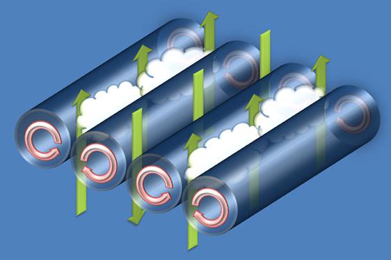
Image credit: Wikipedia/Daniel Tyndall, Department of Meteorology, University of Utah
It’s more complicated in practice, of course, but the overall pattern is pretty obvious. It’s actually not all that rare, but somewhat difficult to study. I’d imagine long term observations by satellites like Aqua will lead to a better understanding of this elegant, but oh-so-chilly, phenomenon.
And as an aside: No doubt, these cold snaps and huge snowfalls will be touted by the global warming denial crowd as evidence against warming. However, that’s wrong: 2012 was an abnormally hot year in the United States, the hottest on record. This is why the Great Lakes have unusually warm water right now (it takes a while for water to shed heat), which is in turn why the lake effect snow is so strong. Not only that, the warmer weather means less ice on the lakes, so the water could evaporate more as well, adding to the lake effect; the amount of ice on the lakes in winter has been declining for years. This cold weather in the Midwest is not all that unusual (it happened for similar reasons in 2009), but the warm water is. And while it’s hard to blame global warming for any particular weird weather event—like, say, nine of the ten hottest years on record having occurred in the last decade—over time, it loads the dice that way.
Tip o’ the parka hood to Tom Skilling via Kirk Korista on Facebook.