Regular readers know I am fascinated by volcanoes, and I love pictures of them taken from space.
On. Nov. 27, 2012, the remote Russian volcano Plosky Tolbachik erupted. Located in the far east of Russia on the Kamchatka peninsula, Tolbachik is actually a complex of volcanoes with two main peaks and several smaller cones. In late November, a fissure, or crack, in the Earth several kilometers long started pouring out lava and has been doing so continuously for weeks (as of Jan. 2 at least it was still erupting). The lava extruding from the vent is fast-moving, and has flowed at least 20 kilometers (12 miles) since the eruption started.
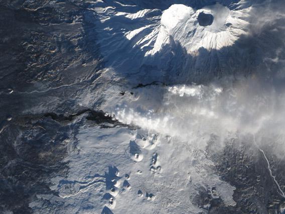
The image above was taken by the Earth Observing-1 satellite on Dec. 22, 2012. You can see the main peak to the north (upper right); the crater at the top is obvious due to the shadow of the crater rim falling across it. The plume from the new eruption—a mixture of ash and steam—is blowing west toward the Pacific Ocean, and you can see the shadow of the plume on the flank of the main peak. In this picture fresh lava is black and older lava is gray, the latter having had enough time to cool and get a coating of snow. This type of eruption is called strombolian (after the Italian volcano); characterized by medium activity and small explosions, unlike other volcanoes that can explode catastrophically and cause widespread destruction like Mt. Vesuvius did.
In the satellite picture you can also see a line of cinder cones to the south, which were created in the last eruption in 1975. That eruption happened after the largest earthquake ever recorded in the region, and lasted for well over a year. This new eruption is expected to continue for several months.
Footage from the ground is, of course, no less dramatic! Here’s some amazing footage of the rivers of lava flowing from the fissure:
There is also some video of scientists at the scene, as well as tourists flocking to the area to see it for themselves. I wish I could see this in person as well! From a safe distance, of course.
Monitoring active volcanoes both from space and from the ground gives scientists vital data from different angles, both of which are needed to help us understand these massive geologic events. And given their impact on both the planet and on us, the more info and knowledge we have, the better.
[Note: If you like volcanoes as much as I do, then allow me to plug my company Science Getaways: we’ll be touring Oregon volcanoes in June!]