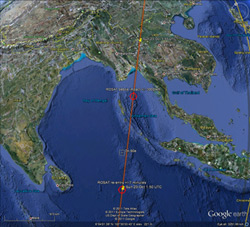
 The German space center DLR is reporting that ROSAT – an astronomical satellite launched in 1990 – re-entered the Earth’s atmosphere just after 01:50 UTC last Sunday, October 23, burning up over the waters of the Bay of Bengal, to the southwest of Thailand. This was during the day, which is why there were no reports of it coming in, and no reports of debris hitting the ground. There are no reports of anyone getting hit, either, of course.
I was thinking about why it’s so hard to know exactly where and when a satellite comes down. New Scientist has a short, to-the-point article about it. In a nutshell, low-Earth orbit satellites like ROSAT are a few hundred kilometers above the Earth’s surface, circling every 1.5 hours or so. The Earth’s atmosphere doesn’t just stop if you go high enough; it thins out slowly, and even at 300 km there is still some air, though incredibly tenuous. However, over days, months, and years, a satellite moving through it feels a drag, feels air resistance. This drops its orbit, putting it into thicker air, which slows it faster, dropping it more… this process is very slow at first, but at some point increases rapidly, and the satellites drops into air thick enough that, at its high speed, causes it to burn up. I’ll note it’s mostly due to gas compression, not friction, that heats the satellite up.
And that’s why it’s so hard to know in advance where these things will come down. Solar wind and solar storms can puff the Earth’s upper atmosphere up even higher, increasing that drag. A heavy, small satellite has less drag than a light, big one. If the satellite is tumbling end over end, the drag changes. The interaction between the satellite and the air is incredibly difficult to model, and the best way to see what’s going on is to actually measure how fast it’s dropping and extrapolate. But even then, the exact place a satellite falls is hard to determine. They’re moving at 8 km/sec (5 miles/sec), so a few seconds off in the prediction means a huge uncertainty in where it will fall.
And, of course, the Earth is big. Very, very big. Chances are, there’s no one around to actually see where a satellite falls, so the exact location may never be known.
The funny thing, as New Scientist points out, is that the US has Earth-observing satellites that can probably see the infrared flare from a satellite as it burns up, and pinpoint the location. However, those are military (or NRO) satellites, so the data are secret – they’re used to look for the heat signature of missile launches. So, understandably, the government would prefer not to release the data, which would allow the bad guys to know our capabilities.
Over time, we’ll see more satellites coming down, and hopefully, like ROSAT, it’ll be over the vast waterscapes of the planet.
Image via Google Earth and @ROSAT_Reentry
Related posts:
- ROSAT’s final hours
- Doomed ROSAT captured in video
- UARS official re-entry… and up next: ROSAT