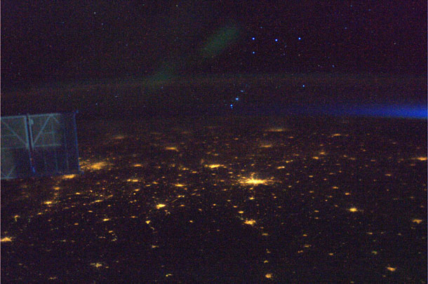
Around the time of Earth Day (April 22) this year, International Space Station astronaut Ron Garan posted several pictures he took of the Earth from space. They are all remarkable, but one in particular caught my eye:
 [Click to embiggen.] Isn’t that awesome? You can see city lights on the ground, part of a solar panel structure on the left, and even the Belt and dagger of Orion as the constellation’s stars set over the western horizon. It’s kinda neat to see objects a few meters away, a few hundred kilometers away, and few quadrillion kilometers away all in the same shot!
When Ron tweeted the link to this picture, though, he only gave a time and date he took it – April 21 at 20:34 GMT – but not what he saw, nor the position of the ISS over the Earth. I was curious: what city lights are those?
And, as it turns out, sometimes simple questions lead to complex, tortuous answers.
The immediate answer is, I’m not sure. Maybe someone out there in blogland can help me! But let me tell you the tale first.
OK. The ISS orbit is known well enough that given a certain time, its position over the Earth can be found. We need that first to figure out what cities these are. So, where was the ISS? I started poking around the web, and was surprised that the answer wasn’t immediately obvious. I use Heavens Above to find when the ISS passes over my town, but it doesn’t give solutions to the position of the ISS for a given time. None of the other software I looked at could either.
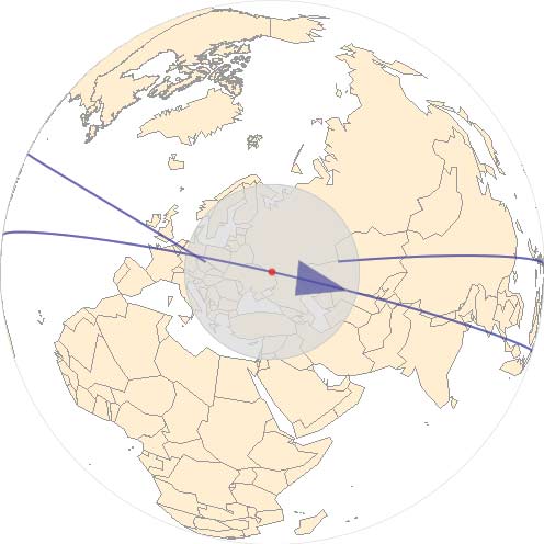
So I decided to Twittersource it! I asked my followers who knew how to do this, and within a couple of minutes DaveGW came through, telling me I could use the amazing Wolfram Alpha software site for it. Sure enough, it delivered, giving me this picture here:
 Coooool. The position of the ISS at that time is marked (over Belgorodskaya Oblast, Russia, just east of the Ukraine border), the orbit is given as the purple line, and also very importantly, it marked that gray circle. That covers the area of the Earth from which you could see the space station, or, conversely, the part of the Earth you can see from the space station!
OK, excellent first step. But what direction was Ron facing when he took the picture? Happily, the Belt of Orion tells us that: at this time of the year, Orion sets just north of due west in the sky. It’s still a bit above the horizon, but this means Ron was definitely facing west, and looking perhaps a bit south as well.
So then what’s needed is a map of eastern Europe centered on Belgorodskaya Oblast that I could rotate to look west. At this point the web didn’t help much. I thought about it for a second, then realized I have an amazing tool I haven’t used in a long time.
An atlas.
Yes, an actual book you hold in your hands; I was sent one years ago as partial payment for one of the first paying articles I ever wrote. So I pulled out the atlas, found the area I wanted, turned it so I was looking west…*
And stopped. Hmmm. There are a lot of cities in that area, and it’s actually hard to tell what’s what. You have to be careful; the picture Ron took is near the horizon, where the curvature of the Earth distorts distances wildly. The cities in the foreground might be a few hundred km away, while the ones near the horizon might be over 1000!
We do have some good clues though. The gray circle in the visibility map goes as far west as Denmark, cutting across Germany. Cities on the horizon can’t be farther away than that.
So poking around, I found a rough match. I think the big city just below and to the right of center is Warsaw, Poland. The city just above and to the left could then be Lodz. It has a population of 700,000 compared to Warsaw’s 1.7 million, so the amount of city lights looks about right.
Well over to the left (south and west), partially blocked by the solar panel, lie two populated regions. These may be Krakow and Katowice.
Finally, almost to the horizon, right under Orion’s belt, might be Berlin. Distance and haze would dim the city lights, but at this point I’m just guessing.
So now I’m at my limit. I’d love to have some software that would allow me to simply say, “Show me the view from ISS on this day at this time, looking west.” However, I tried a few free programs (Celestia, Cartes du Ciel) and had no luck. If anyone knows of any software like this, I’d love to see it! And if you have any insight on this picture, leave a comment below.
It’s amazing to me that the Earth is so big and sometimes so difficult to pin down. But then, I love the fact that asking such a simple question – “What am I seeing here?” – can turn into a puzzle that can be so much fun to solve.
* At that very moment my wife walked into my office and asked me what I was doing. I told her, and she asked “Why are you spending so much time on this?” I replied, “It tasks me. It tasks me, and I shall have it!” She looked at me oddly and walked away. A “Wrath of Khan” aficionado she is not. But of course: “Humor. It is a difficult concept.”
Related posts:
- Goodnight, Earth
- Fire and ice
- Squishy Moonrise seen from space
- Guess the planet
A puzzling planet picture from the ISS
Advertisement