[UPDATE (April 5, 2011): It turns out some of the descriptions I used below to describe a geoid were not accurate. I refer you to this page at the University of Oklahoma for a good description. I’ve made some changes below to hopefully ease any confusion.]
Most people think of the Earth as being a sphere. For most purposes that’s close enough, but it’s actually a spheroid, something close to but not precisely a perfect sphere. It bulges in the middle (as so many of us do) due to its spin, the Moon’s gravity warps it, the continents and oceans distort the shape. And the surface gravity changes with all this too; it’s different on top of the highest mountain, for example, compared to its strength in Death Valley.
So if you could map out the average shape of the Earth’s gravity, a shape where the gravity is the same no matter where you stood on it, what would it look like?
So if you could map out the Earth’s gravity – essentially, a diagram showing you the direction of “down” – what would it look like?
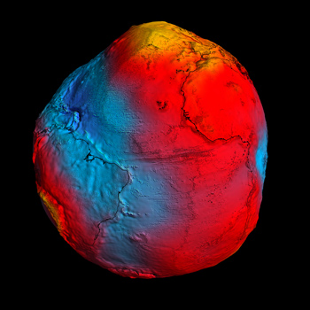
It would look like this:
That is a (somewhat exaggerated for easy viewing) map of the Earth’s geoid, produced by the European Space Agency’s GOCE satellite. A good way to think of the geoid is the shape a global ocean would take if it were governed only by gravity, and not currents or tides or anything else. If the Earth’s gravity were a little stronger in one place, water would flow toward it, and if it were weaker water would flow away. In the end, the surface of this global ocean would feel the same gravity everywhere, shaping itself to the geoid. If the Earth’s surface were an actual geoid, then the direction of “down” would point perpendicularly toward the geoid surface (or, in the same vein, if you had a carpenter’s level, the level would be, um, level if it sat parallel to the geoid). It’s the ultimate “sea level”.
This may seem esoteric, but this knowledge is actually important. For one thing, it gives a standard reference for topographic maps. For another, it will help scientists better understand ocean currents, circulation, sea wave heights, and other tricky measurements. There are many uses for such a geoid map.
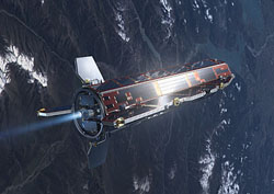
 GOCE – for Gravity field and steady-state Ocean Circulation Explorer – has been orbiting the Earth since 2009, using extremely sensitive accelerometers (like what your smart phone uses to measure movement, but a whole lot more precise and expensive) to detect the whispery tug of gravity on the spacecraft. If it passes over an area with slightly higher gravity, the spacecraft accelerates a bit, and the detectors measure that. Over time a map of Earth’s gravity is built up, resulting in the measurement of the geoid.
The map itself is pretty cool. Since this is the shape of a global ocean, you can see the lump over the north pole means gravity is a bit stronger there, and the same is true over southeast Asia and other land masses. That may sound counterintuitive, but think of it this way: where the gravity is stronger, the water will flow toward that place, piling up, and the geoid sticks up more. The weakest gravity is in the Indian Ocean, where the map is deep blue. A global ocean would flow away from there, leaving a depression. [UPDATE: Sorry about the confusion here, but this is where I blew it: the strength of gravity is not necessarily the same on the geoid everywhere; it’s just where the gravity potential is the same. The two are related but not the same thing. Again, think of the geoid as the surface where the force you feel down from gravity is always perpendicular to the surface.]
 GOCE is actually a pretty cool spacecraft. It had to fly in low orbit to get the best measurements, but at an altitude of just 280 kilometers (170 miles, much lower than most satellites) there is a trace of air. That air drags on the satellite, lowering its altitude. GOCE has a long, sleek shape to help minimize drag, but more importantly it uses an extremely low-thrust ion engine which is precisely calibrated to counteract the atmospheric drag. Without the engine, GOCE would lose about 200 meters of altitude a day, and quickly re-enter.
I find this whole project pretty interesting. Gravity is a very weak force, and measuring it with such precision is an amazing achievement. GOCE has mapped the geoid to a vertical accuracy of 1 - 2 centimeters – about an inch! I don’t think the GOCE geoid will replace globes across the world in classrooms – it’s a bit off-putting, I’ll admit, and distressingly lumpy – but I do hope that people get an idea that while the Earth is pretty close to a perfect sphere, nobody, and no planet, is actually perfect.
Image credit: ESA/HPF/DLR
Related posts:
- Ten Things You Don’t Know About The Earth
- The cloudy, warming Earth
- A glint from Earth
- How far away is the horizon?