Travis Haas, a New Orleans high school science teacher, says that ever since Hurricane Katrina, his students have endured so many lectures and lessons on the importance and vulnerability of Louisiana’s wetlands that many develop “wetlands fatigue”—rolling their eyes and tuning out faster than you can say “bayou.”
Luckily, wetlands fatigue is nothing a little DIY civic science can’t cure. This past academic year, Haas and his students at New Orleans Center for Creative Arts, an arts-focused high school, worked with the nonprofit Public Lab to monitor the health of urban wetlands. The students also piloted a new hands-on coastal wetlands curriculum, which Public Lab created alongside its core mission—developing low-cost environmental sensors, aerial photography rigs, and free open-source mapping software to give everyone the scientific tools to be environmental stewards.
“These activities got the kids talking about wetlands again, and talking about them in a deeper way than they ever had before,” said Haas, who also heard from parents that kids had come home eager to discuss Louisiana’s rapid wetland loss—about 29 square miles a year, according to the U.S. Geological Survey.
Last fall, NOCCA students tromped out to polluted wetlands in New Orleans’ parks and along Lake Pontchartrain. In low-lying, easily flooded New Orleans, the loss of wetlands from development and pollution means more energy and money spent pumping away the storm water that healthy wetlands would have absorbed. The kids were led by Public Lab outreach manager Stevie Lewis, who regularly works with students to map these wetlands from the air, a project backed by the Environmental Protection Agency.
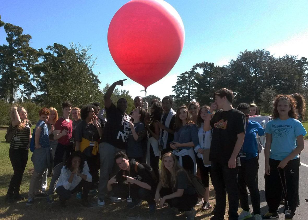
The students’ equipment consisted of a point-and-shoot camera fixed inside a clear plastic soda bottle and rigged up for continuous shooting while hoisted high over the park by a giant red helium balloon.
While NOCCA’s artistic students enjoyed lofting the giant red balloon, they really loved using MapKnitter, Public Lab’s open-source software, to stitch together all those images into maps that could be compared with other maps made over time. “They nailed it,” Haas said. “They are fascinated by film and images. They think in that way.”
The mapping excursions aren’t just field trips. Public Lab’s small staff has a lot of ground to cover. So they count on volunteers, both adults and students, to be true collaborators who make accurate maps that track the wetlands’ health. Two weeks ago, Lewis led another group of high school students from the city’s Lower 9th Ward—one of the areas hardest hit by the Katrina flooding—who are fulfilling their schools’ public service requirements with an environmental nonprofit called Groundwork New Orleans.
“If those students hadn’t been there to help me, I would have had a hard time,” said Lewis. “Public Lab is about collaborative knowledge-building. So students learn, and we learn from working with them. Maybe they figure out a better way to set up the camera or put together the soda-bottle rig.”
“We want to get people thinking openly and creatively about how to solve problems,” she added. “And that’s what students do best.”
In the spring of 2010, as British Petroleum’s disabled Deepwater Horizon drilling platform gushed oil into the Gulf of Mexico, the company persuaded federal authorities to make the spill a no-fly zone, which meant no one could see the extent of the slick. In response, a group called Grassroots Mapping teamed up with environmental activists to fly camera-toting balloons and kites over the spill and make maps of the devastation, which were picked up widely by mainstream media.
Later that year, the activists formed Public Lab to spread the gospel of DIY environmental science, via online illustrated tutorials, how-to videos, and blog reports from citizen scientists around the world. There are now 15 Public Lab chapters and a global online community.
“We didn’t start off focused on formal education,” said Shannon Dosemagen, Public Lab’s executive director. “But informal education, through peer-to-peer learning, training and field work, is very much embedded in the work we do.”
Indeed, plenty of educators have joined Public Lab’s online community, especially since 2011, when Public Lab started selling inexpensive kits and spare parts for balloon and kite mapping, infrared imaging equipment to monitor plant health, and basic spectrometers to test water for pollutants.
Teachers and staff at after-school programs and student “maker spaces” buy Public Lab kits in bulk, either for science labs or student participation in environmental restoration efforts, including the Los Angeles River and the Passaic River in New Jersey.
“Putting together a tool helps you understand how it works, how data is collected and analyzed, and how you might be able to adapt it for your particular needs,” said Matthew Lippincott, Public Lab’s production director based in Portland, Oregon. “It demystifies the scientific process so people can start taking control of environmental problems.”
In fact, Lippincott’s tinkering indirectly led to the curriculum Public Lab piloted with Haas’ students this past spring. The short version of the story is that Lippincott wanted to modify a small camera made for a bare-bones computer called a Raspberry Pi so it could take infrared photos. Thriving plants with healthy amounts of chlorophyll reflect back more near infrared light, which digital cameras can detect but the human eye can’t. Most cameras have a built-in filter that blocks infrared, and that’s the gizmo Lippincott had to remove.
“It was a pain in the butt,” he said. “I posted a YouTube tutorial where I took the camera apart under a microscope with a scalpel.”
That tutorial was so popular that Raspberry Pi’s makers decided to change their camera so it could be more easily modified for infrared. As a thank you to Lippincott, they asked what Public Lab initiative they could support through their foundation. The answer was easy. For years, educators who used Public Lab’s tools and tutorials had clamored for lesson plans to go with them.
So, backed by the Raspberry Pi Foundation, Lippincott and Amanda Fisher, a curriculum developer for the Oregon Museum of Science and Industry, created four hands-on lesson plans about coastal wetlands, which they posted online and are now tweaking to meet Louisiana’s education standards. Students make clay models of wetlands and observe the impacts from simulated canal cutting, dredging, and subsidence from oil drilling operations. They also grow bean sprouts, coat some of them with oil, then modify a digital camera so they can take infrared images to compare stressed and healthy plants. Haas says asking students to remove the infrared filter from a camera is just as important as teaching them about wetlands or plant health.
“A real strength of the curriculum is the DIY part,” he said. “Instead of seeing science as something that’s canned and error-free, it gives students a task that requires real strategy and problem-solving skills. Creativity is a part of science that’s not often seen in secondary classrooms, but it’s a very important part of the process.”
This story was produced by the Hechinger Report, a nonprofit, independent news organization focused on inequality and innovation in education. Read more about blended learning.