
Two weeks ago, after months of mounting public pressure, Inmarsat and the Malaysian government finally released the raw satellite data that had been received from the missing Malaysia Airlines Flight 370. Most of the data dump proved unrevealing. But tucked away amid 47 pages of detailed communications logs and explanatory notes was a two-sentence description of the plane’s electronics system that turned out to be a doozy. Combined with previously released data, publicly available information, and a little vector mathematics, it has proved sufficient to lift the veil on Inmarsat’s calculations and reveal the ultimate fate of the plane.
The story goes back to March 25, when Malaysian authorities announced that an analysis of the data had determined that the plane must have wound up in the southern Indian Ocean. An explanatory document released at the time purported to back up that claim with charts and numbers, but as I’ve written earlier, it in fact was so obtuse that it didn’t really clarify anything at all. The message’s subtext was basically: Trust us, we know what we’re doing. But the subsequent behavior of the search officials—who, among other things, promised that they’d located the plane underwater but then came up empty-handed—left little room for confidence. Many, including me, wondered whether the authorities were hiding something, or else trying to conceal how little they knew.
The impenetrability of the report didn’t stop an impromptu squad of amateur sleuths from trying to crack open its secrets. Experts with backgrounds in satellite communications, space science, and avionics banded together on the Internet to swap insights and exchange theories. For two months, they beavered away at the problem. The idea was that if they could reverse-engineer the original data out of the tables and diagrams that Inmarsat had released, they could undertake their own analysis of what happened to the plane and offer alternate suggestions about its fate.
A way to understand the nature of the Inmarsat data is to imagine that your drunken brother-in-law has stolen your motorboat and is careening around on a pond in a thick fog. You’re standing on the shore and want to know where he is. You have a foghorn, and let’s just imagine that every time you blast it, he immediately blasts his foghorn in reply.
The sound of his foghorn tells you two things. First, knowing the speed of sound and your brother-in-law’s reaction time, you can work out how far away he is by how long it takes you to hear his blast. You won’t know his exact location, but you’ll know the radius of an arc that he’s positioned on. In the case of the Inmarsat data, this would correspond to the so-called ping rings, the final one being the famous Northern and Southern Arcs where the plane is presumed to have wound up.
The second clue you can glean from your brother-in-law’s foghorn is the frequency of the sound, which will tell whether he’s going away from or coming toward you. This is thanks to the Doppler effect, the same phenomenon that makes a train whistle sound higher-pitched when it’s coming toward you and then suddenly lower once it zooms past. If you know the original frequency of your brother-in-law’s foghorn, the difference between that and the pitch of the sound you receive will let you determine his speed—not his total velocity, mind you, but the extent to which he’s moving closer or further away. In the case of MH370, the equivalent data is called burst frequency offset, or BFO.
Essentially, if we derive the distances from the timing offset, and the instantaneous speeds from the frequency offset, we have two solid sets of clues as to how the plane was moving. Unfortunately, when authorities released their report on March 25, they didn’t include any BFO or ping timing numbers, but only a chart from which a crude approximation of the BFO numbers could be gleaned and a chart showing a possible track from which distance values could be estimated.
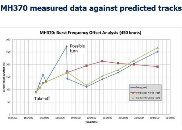
Courtesy of the Inmarsat report
In the weeks that followed, the Malaysian authorities released further information that allowed for better estimations of the ping rings. But the BFO data remained hopelessly obscure. Without it, independent experts struggled to understand why Inmarsat claimed that the plane could not have gone north. Some even suggested that Inmarsat engineers might have made a basic math error and flubbed their whole analysis. The headline of one much-discussed Atlantic article summed up the skeptics’ perspective: “Why the Official Explanation of MH370’s Demise Doesn’t Hold Up.”
For their part, the authorities clung fast to the hope that their detective work would be vindicated once a search of the ocean bottom revealed the airliner’s wreckage. When it didn’t, their credibility was at a nadir. Public pressure was mounting, especially from the impassioned and increasingly well-organized family members of the missing passengers. At last, on May 27, Inmarsat and the Malaysian authorities released the raw satellite data. With great anticipation, the scattered legion of experts opened the document and set to work. Their excitement quickly faded. Most of the document consists of a mass of logged data that shed no light on the fate of the plane. The timing-offset numbers were similar to the values that had already been deduced. And while the burst frequency numbers were finally revealed, it proved impossible to turn them into velocity values without an accompanying explanation of the equipment used to create and relay the signals. “In fact,” says Mike Exner, one of the leading independent experts trying to make sense of the Inmarsat data, “it has become more difficult to understand the BFO values, not less.”
If the data themselves proved disappointing, two brief sentences in an accompanying page-and-a-half-long explanatory note turned out to be a sleeper. It read: “Inmarsat Classic Aero mobile terminals are designed to correct for aircraft Doppler effect on their transmit signals. The terminal type used on MH370 assumes a stationary satellite at a fixed orbital position.”
From the perspective of independent analysis, this assertion was a bombshell. What it means is that, contrary to general expectation, the plane’s electronics system knew where it was and where it was headed the whole time that it was missing. (Some independent experts, notably Henrik Rydberg, Yap Fah, and Victor Iannello, had previously proposed that this might be the case.) Because it used this information to pre-correct its transmission frequency, the Doppler shift cannot be used to figure out the plane’s instantaneous velocity. But by way of consolation, it’s now possible to figure out pretty much exactly where the plane went.
Imagine that your brother-in-law is still out on the foggy lake, but this time he has a GPS unit with him, so he knows how fast he’s going and where he is. Let’s imagine he also has a special high-tech foghorn that lets him precisely adjust its pitch up and down. By knowing where you are in relation to his position, he can calculate the exact frequency to blow his horn at so that no matter where he is or how fast he’s going, by the time it reaches your ears its been shifted to the exact same frequency. You know he’s out, zooming around willy-nilly, but all you ever hear is the same F sharp.
If that were all there was to it, then the story would end there. You would never be able to pinpoint your brother-in-law’s location, and Inmarsat would never be able to locate MH370. But there’s a wrinkle. Your brother-in-law thinks that you’re standing still in a certain position, but in fact you’re a short distance away from that spot, and you’re moving. As a result, what you hear isn’t exactly F sharp.
In the case of MH370, the satellite communication equipment was programmed to assume that the Inmarsat satellite in question was orbiting over a fixed position at the equator. But in fact its orbit has a slight wobble. During the hours the plane was missing, the satellite was above the equator, moving first north, and then south with increasing speed.
This error in calculating the satellite’s position means that the plane’s electronics failed to correctly compensate for its own velocity. When the plane first disappeared from radar, the angular distance between where the satellite was and where the plane thought it was amounted to about 3 degrees, enough to generate a velocity error of 20 miles per hour.
As the hours passed and the plane got farther away from the satellite, this effect became less pronounced. At the same time, however, a second source of error was growing: The satellite was accelerating on its path toward the Southern Hemisphere. This would cause it to receive an unexpectedly higher frequency from a plane flying south of the equator, and an unexpectedly lower frequency from a plane flying north of the equator. What’s more, this effect would become more pronounced the further the plane was from the equator. A plane traveling north at 450 knots would be traveling away from the satellite at 16 knots more than expected by the end of its flight. For one traveling south at 450 knots, the error would be in the other direction, to the tune of 18 knots.
Understanding all this, we can at last make sense of the mysterious BFO chart from March 25. Just after the plane disappeared from radar, the plane’s position error would have made a northbound plane’s transmission frequency too high, then after a few hours the satellite velocity error would have made it increasingly too low. Conversely, in the early hours after its disappearance position error would have made a southbound plane’s frequency too low, but then satellite velocity error would have gradually made it get higher.
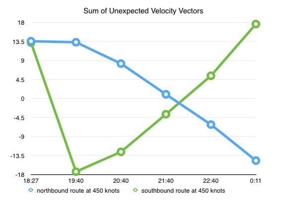
Image by Jeff Wise
Because the satellite’s velocity error becomes so dominant toward the end of the flight, and because that error varies strongly with the latitude at which the plane happened to be, the BFO value basically tells you where along the final “ping arc” the plane was when it neared the end of its flight. And this, we can assume, is why the authorities have been searching the particular stretch of ocean they’re looking at now.
For those like me, who thought it possible, even likely, that the plane might have gone north, this comes as bad news. It seemed to me that there were lots of potential motives perpetrators might have for taking a plane north; what’s more, if the plane went north, one could entertain hope that the passengers might still be alive. At the time I first made that suggestion I was roundly criticized by those who preferred the theory that the plane’s change of course was a result of mechanical mishap. The fact is that none of us had enough information to prove our case, but we were making good-faith efforts to make sense of limited data. Indeed, even now the flight path that we’re left with is difficult to make sense of, since it jibes with neither a deliberate action nor a mechanical failure. Perhaps, as some have suggested, the disappearance took part in two phases: first, a deliberate diversion of the plane to a westerly course, and then, at around 18:25 GMT, an accident or act of violence that sent it heading south as a ghost ship.
To be sure, then, the solution of the Inmarsat data mystery leaves plenty of questions to be answered. If the plane did go into the ocean, why hasn’t any debris been found? If it tracked south over Indonesia, why wasn’t it picked up on radar? And if the final BFO value should give such a clear indication of where the plane wound up, why have the authorities shifted the search area multiple times—and why are experts within the search, as reported yesterday by the Wall Street Journal, continuing to debate the significance of factors like airspeed and fuel burn?
For me, though, the most perplexing question is why the authorities released the Inmarsat information the way they did. For nearly three months now, the public, and in particular the passengers’ families, have struggled to understand why the authorities were so adamant that the plane had gone south. Instead of simply explaining the facts, which as I describe here seem to be pretty straightforward, they obfuscated, delayed, and bluffed. When they finally did reveal the truth, they tucked it away inside a ream of data so as to make its revelation as difficult as possible.
At any rate, the end effect is the same: We the public finally understand the official stance on the fate of the plane. But Inmarsat and the Malaysian authorities could have gotten us to this point without seeming mean-spirited and obstructionist.
This article is part of Future Tense, a collaboration among Arizona State University, the New America Foundation, and Slate. Future Tense explores the ways emerging technologies affect society, policy, and culture. To read more, visit the Future Tense blog and the Future Tense home page. You can also follow us on Twitter.