For the relatives of passengers aboard Malaysia Airlines Flight 370, the announcement by the Malaysian Prime Minister Najib Razak on Monday must have registered as a double shock. First there was the fact that their loved ones were dead: “The past few weeks have been heartbreaking; I know this news must be harder still,” Najib said at a press conference after families were notified. More surprisingly, the announcement was made even though no bodies or wreckage had been recovered. Instead, the passengers’ fate had been determined by math alone. A U.K.-based satellite company, Inmarsat, had deployed a new kind of mathematical analysis to determine that the plane’s trajectory had carried it deep into the southern Indian Ocean, a region where there are were no landmasses upon which a plane can set down. Ergo, the passengers were all dead.
In Beijing, family members reacted with outrage, staging an impromptu march on the Malaysian embassy. One can only imagine how frustrating it must be to be told to abandon hope, to grieve in the absence of any material evidence of loss. They must have wondered if they could really believe what they were being told. Unreliable information has been reported throughout the search process, with assertions made about the flight only to be later refuted, modified, or quietly dropped. Amid all the uncertainty, how much credence should be given to this new mathematical formula, which seemed so complicated that hardly anyone could understand and whose underlying data remains veiled in secrecy?
That’s what I wondered when I heard the news, but after reviewing Inmarsat’s publicly released information with an expert, I’ve come to the conclusion that its findings are most likely sound. With caveats.
Since Inmarsat’s data is the only source of information we have about the fate of MH370, it’s worth reviewing how the system works. Inmarsat is a communications satellite in geosynchronous orbit over the Indian Ocean. Every hour or so, it sends out a short electronic message to subscribers that says, “Hey, are you out there?” The message contains no information as such; the satellite just wants to find out if that particular subscriber is out there in case it wants to talk. Kind of like picking up your telephone just to see if there’s a dial tone. On the morning of Saturday, March 8, MH370 replied seven times to these pings, saying, in effect, “Yes, I’m here.” The line was open for the plane to communicate with the outside world. But the system that generates the messages themselves, called ACARS, had been shut off. So nothing else was communicated between the satellite and the plane.
All the same, those pings tell us something important about MH370: They narrow down its location. Because light travels at a certain speed and electronics take a certain amount of time to generate a signal, there’s always a length of time between the satellite’s “Hey!” and the airplane’s “Yo!” The farther away the plane is, the longer it takes to respond because it has to wait for the signal from the satellite to travel that extra distance.
Imagine you and I are in a darkened room. You have no idea where I am, except you know that I’m holding one end of a taut 20-foot rope, and you’re holding the other. Therefore I must be 20 feet away. You don’t know where I am, exactly, but you know that I must lie somewhere along a circle that’s 20 feet in radius, with you at the center.
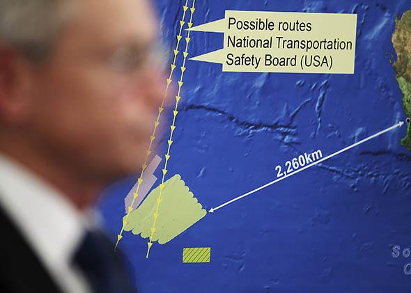
MH370 was in an analogous situation. When Inmarsat pinged it at 8:11 a.m. and received MH370’s reply, the amount of time it took the plane to respond allowed investigators to calculate its distance from the satellite. This did not correspond to a specific location but to an arc of possible locations across Central Asia in the north and the Indian Ocean to the south. This information was announced to the public on Saturday, March 15, by the prime minister of Malaysia.
This result was a huge breakthrough for the investigation, and it raised a question: Could analysis of the six earlier pings narrow down the route that the plane had taken? The U.S. National Transportation Safety Board obtained the data from Malaysia and set to work.
The process is fairly straightforward. The first ping coincided more or less with the time when MH370 slipped out of range of Malaysia’s military radar. So we have a starting point. By knowing the interval to the next ping, and by estimating the plane’s speed, we can arrive at a distance traveled during that time. Given the radius of the next arc, it’s a simple matter to calculate a route by angling the distance traveled to meet up with that arc.
When the NTSB ran the numbers, the resulting plot showed the plane winding up in a remote part of the Indian Ocean, and that’s where searchers began focusing their efforts. Soon after, satellite photos showed large pieces of debris floating in the water, and the Australian Prime Minister Tony Abbott jumped to the obvious conclusion: He announced on Thursday, March 20, that that investigators had found their first hot lead. “This is the first tangible breakthrough,” he said. “This is a very serious lead in the way that nothing else so far really has been.”
There was at least one problem undermining the certainty of Abbott’s assertion. Though the NTSB’s process worked for generating a likely path to the south, it could also be used just as effectively to create a path to the north. The satellite data itself is ambiguous—it provides no clues about which direction the plane is moving. So when the NTSB was plotting out a route to the south, it was also effectively plotting a mirror route, symmetrical to the first, that stretched northward along the Himalayas and on to Kazakhstan.
U.S. and Malaysian officials were said to favor the southern route, but some people (including me) argued that the northern route was more plausible. It allowed for a denouement in which whoever was in control of the plane came out alive. But there was really no way to tell until an aircraft or identifiable wreckage came to light. The satellite data was inherently ambiguous.
Or at least, that’s what many of us thought. But somehow the clever engineers at Inmarsat managed to squeeze one more drop from the thimbleful of data contained in those pings. They’ve been a little cagey about how exactly they did it, so I turned to communications-satellite pioneer Mike Exner, president and CEO of Radiometrics Corp., to explain how he thought they extracted more information.
“This is an old satellite,” Exner said. “When satellites start to run out of hydrazine, you can’t keep them exactly geostationary.” Instead of keeping perfectly still above a certain spot, the satellite begins to slowly wobble. Over the course of the day, it makes a narrow figure eight around a central spot located on the Earth’s equator.
“It’s a small effect,” Exner says, “And normally you’d overlook it.” But in the hunt to overcome the symmetry of the ping data, Inmarsat likely realized that it could use the wobble of the satellite to its advantage. The satellite itself, depending on where it is in its orbit, will have a different relative motion compared to a northbound and a southbound plane. That relative motion can be detected as a Doppler effect, the frequency change you hear when a train whistle that’s coming towards you dips in pitch as it whooshes past. The effect was subtle and difficult to tease out of the data, but when Inmarsat ran simulations, it found that the amount of Doppler effect observed in the MH370 data matched the predictions for the southern route and not the northern one. Comparisons with other flights whose location and speed were known supported that conclusion. That’s the finding that the Malaysian prime minister reported.
So do we know now where MH370 went? Not exactly. The path that the plane is presumed to have taken still depends on the speed that the plane is presumed to have been flying. Inmarsat generated routes based on two different airspeeds—400 knots and 450 knots—and came up with end points that are hundreds of miles apart.
For his part, Exner believes the range of route possibilities is even larger than Inmarsat’s projections suggest. He points out that MH370 was detected diving to 12,000 feet before disappearing from Malaysian military radar. A Boeing 777 going 310 knots at 12,000 feet burns a bit less fuel than one going 440 knots at 30,000 feet, so there’s no question it could have stayed aloft that long. The resulting flight profile is still consistent with Inmarsat’s ping distance and Doppler data, but results in a track that is much shorter and curves to the east near the south coast of Sumatra and Java.
Even though Inmarsat’s presumed approach makes sense and its calculations seem credible, that is not to say that its results are necessarily accurate. Before scientists publish a finding, it must undergo peer review by independent authorities in the field. Inmarsat has declared itself absolutely confident in its results and says that its results were “peer-reviewed” by the British government, but showing one’s work to self-chosen sympathetic colleagues is not peer review. Until Inmarsat’s findings are looked over by a truly independent panel of experts, it will be hard to have unequivocal confidence in the report.
And if searchers don’t start finding wreckage in the current search area soon, it might be time to revise some basic assumptions—and start to look in a different place.
Read the rest of Slate’s coverage of Malaysia Airlines Flight 370.