The Appalachian Trail spans more than 2,000 miles across 14 states, traversing woodlands and peaks from Springer Mountain in Georgia to Mount Katahdin in Maine. It is one of the world’s longest continuous footpaths, and each year thousands of individuals attempt to hike the entire thing.
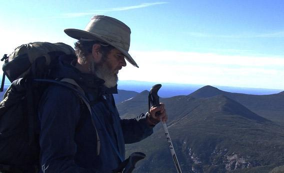
For any thru-hiker, making the trek is an accomplishment (fewer than 25 percent successfully complete the journey). But that’s especially true if you’re blind. Which is why it’s so impressive that Minneapolis-based attorney Mike Hanson set out along the Appalachian Trail in the spring of 2010. Using only a GPS device and trekking poles, the visually impaired Hanson plotted and completed the majority of the Appalachian Trail without outside assistance, making an important point about the power of technology and the independence of those without sight.
Born in Madison, Wis., Hanson has been blind since birth. When he was born prematurely, doctors gave him a high concentration of oxygen, which damaged his retinas. Despite his impairment, Hanson is an avid outdoorsman. As a child, his father’s stories about pheasant hunting in rural South Dakota inspired him to seek out wilderness. Later on, Hanson became a president of Capable Partners, a program designed to help visually impaired individuals partake in hunting and fishing by providing them with seeing partners as aides.
These experiences motivated him to pursue a long-distance hike, and the AT seemed like a fitting goal. Many other visually impaired individuals have completed similar journeys—among them Bill Irwin, who hiked the AT with a guide dog—but few have employed GPS systems. Hanson firmly believes that technology has the potential to change the way that the visually impaired interact with the world, and he suspected that using GPS to complete a big-ticket hike would help him prove his point. For years, though, the technology was both too expensive and too limited in its capabilities, which meant Hanson had to put his plans on hold.
Finally, in 2006, he noticed an increasing “availability of GPS that you can use without sight.” Using his Nokia N82 cellphone, Hanson downloaded a Loadstone GPS system, which is a free, open-source application specifically designed to facilitate the mobility of blind and visually impaired persons. The Loadstone GPS system allows its users to search for points of interest in an area—such as grocery stores, schools, and office buildings—and store those sites along with labels for future use. With the addition of screen reader technology, the Loadstone program can then provide oral instructions, letting a user know when to turn and when a destination is nearby, all with the help of clock-face directions. This data can later be shared online with other users, leading to a crowdsourced database of sites. Unlike, say, your iPhone’s navigation system, the Loadstone program does not have extensive existing data points; however, the Loadstone program allows visually impaired users to create their own personalized databases at a low cost.
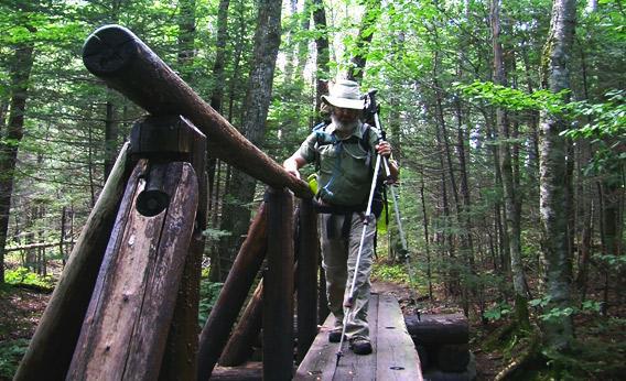
Photo by Gary Steffens.
For his hike of the Appalachian Trail, however, Hanson needed more detailed maps than crowdsourcing could provide. Hanson gathered data from the Appalachian Trail Conservancy and other sources and converted the information to the Loadstone GPS format on his phone. Hanson then used tools on the Loadstone website—such as a route planner function—to generate checkpoints along the trail. These locations—created by entering geographical coordinates into the route planner—included things like campsites, trailheads, and water sources. Most importantly, the Loadstone tools allowed Hanson to store oral instructions along with each point, which would be necessary on the trail.
Over the course of the next few years, Hanson continued to update his GPS device while pushing himself into top physical shape. In true sports montage fashion, Hanson did everything from hiking to lifting weights to walking on a stair climber with a backpack. In 2007, Hanson flew to Shenandoah National Park for a week and hiked part of the AT in order to test his Loadstone system. The majority of his data proved to be accurate, and each major point was within approximately 20 feet of the GPS estimation. The test run also showed Hanson that he would need a GPS receiver with longer battery life. Hanson replaced the receiver—moving from a six-hour battery to a 32-hour battery—and began to make final preparations for his hike.
On March 6, 2010, Hanson began his journey in Georgia, followed closely by Gary Steffens, a filmmaker who decided to document the trek. The two carried 40- to 50-pound backpacks filled with all of the necessary materials, including first aid kits, tents, maps, and food. For the majority of the trip, Hanson combined the use of his GPS with the employment of trekking poles. At each checkpoint, Hanson would listen to his GPS and gauge the distance and direction to the next site. Then, intermittently along the trail, Hanson could verify his position and maintain the correct orientation. While the GPS kept Hanson on track in a macro sense, his trekking poles alerted him to smaller details, such as obstacles and turns in the trail. Hanson’s sense of hearing allowed him to locate water, campgrounds, and other important sites that were not indicated on his maps.
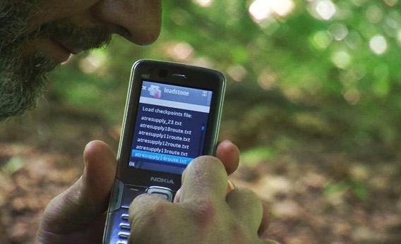
Photo by Gary Steffens.
Occasionally, dangerous weather and terrain proved challenging. Before Hanson even set foot on the trail, a late spring blizzard blanketed the AT with snow, making it difficult for Hanson to be sure he was on the right path. Later, on Blood Mountain in Georgia, Hanson explained, the men “faced heavy rain, strong winds, and slopes we had to slide down.”
Although these setbacks slowed his pace—and forced him to skip a few sections of the trail—Hanson remained steady and, in early October, he began hiking the summit of Mount Katahdin in Maine, the final hurdle of the AT thru-hike. With the help of two Maine residents he met that day, Rita and Bain Pollard, Hanson found good foot- and hand-holds along the Hunt Trail up Katahdin. On Oct. 2, 2010, Hanson and his companions reached the top, the pinnacle of seven months and 1,700 miles of hard work.
Reflecting upon the demanding trip, Hanson chooses to focus on its broad implications rather than its personal significance. Although Hanson has found success in a variety of roles—most recently as an attorney—he recognizes that many people are unaware of the tools and tactics that can allow blind people to accomplish a variety of tasks. According to the American Foundation for the Blind, 70 percent of legally blind individuals and 55 percent of visually impaired individuals are unemployed. Hanson wants to inspire these individuals to pursue grander goals, and he believes that “with the right technology, one can do quite a few things.”
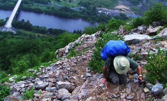
Photo by Gary Steffens.
Unfortunately, although a lot of good technology exists, Hanson explains that there is a “gap between what is available cost-effectively … and what potential employers know about.” Many employers are wary of hiring visually impaired individuals because they are unfamiliar with their condition and may be misinformed about the cost of the technologies required to address it. Even worse, many visually impaired individuals are themselves unaware of the newest technologies.
Hanson is determined to address these issues, and hopes that his hike can help demonstrate the possibilities. He has written a book, and is in the process of developing new GPS technology with his business partner, Harlan Jacobs. Through their company, Wayfinder Angels Corporation, the two are working to improve upon current products while also raising awareness about tech aids in general.
As he plans his next adventure on the Pacific Crest Trail, Hanson reminds us to never “give up on an idea because you don’t know how to make it happen right now. Give it time … and just keep paying attention to what is going on in terms of technology in the world around you. Maybe not today, maybe not tomorrow, but at some point you’ll figure out a way to make it happen.”