This year’s holiday season has been full of extreme weather, with weird anomalies from coast to coast—like a script worthy of a Syfy network movie.
The week of Christmas was the warmest on record by far for a vast stretch of the eastern United States from Texas to Maine. In Philadelphia, every single day this month has been warmer than normal—if that word even retains meaning during a month like this.
While this month’s extreme weather is primarily due to an atmosphere supercharged by the record-breaking El Niño, it’s also an example of the kind of unnerving meteorological event that’s becoming more likely as climate change plays an increasingly large role in daily weather. The New York Times called it “a fitting end to the warmest year on record.” Together, El Niño and climate change have combined for a year unlike any other in human history—a harbinger of an altered planet.
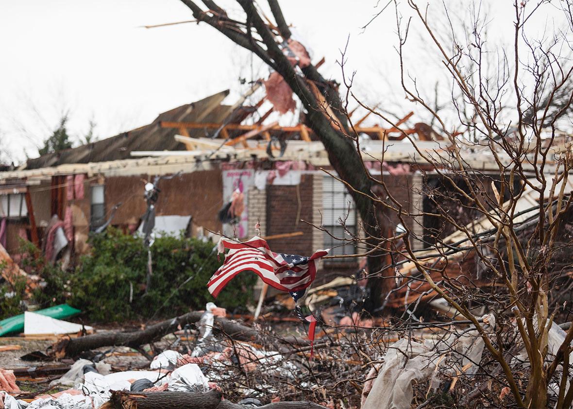
Over the past several days, an alarming string of tornadoes has left dozens dead across the South. At least 68 tornadoes were reported in 15 states from California to the Carolinas from Dec. 21 to Monday, the longest streak on record of December days with a tornado. December tornadoes are twice as common during El Niño years, but this weekend’s atmosphere over the South was something different entirely: By some measures, it was the most moisture-laden ever seen during the winter months.
One tornado in northern Mississippi on Wednesday was so strong it ripped the carpet off the floor after destroying a home. A series of tornadoes also struck Northern Texas the day after Christmas, many at night, creating horrific devastation. The worst one seems to have occurred in Garland, Texas; it was the deadliest tornado in the Dallas area—for any month—in nearly 90 years. Meteorologist Bob Henson notes that 2015 is the first year since 1875, when records began, that there have been more tornado-related deaths in December than in the entire rest of the year combined.
The Texas tornadoes were part of a much larger storm system that at one point encompassed about half the country. The same storm system also brought heavy rains to the Midwest that threaten one of the biggest floods in history on the Mississippi River south of St. Louis, surpassing even the legendary 1993 flood. Road closures due to high water blanketed Missouri, and water levels will continue to rise for several days as record floodwaters from Oklahoma make their way toward the Gulf of Mexico.
On its western and northern fringes, the storm brought snow, the worst of which struck New Mexico. There, Gov. Susana Martinez activated the state’s National Guard and said the historic snowstorm had created a “dire situation.” In fact, at the exact same time that tornadoes were bearing down on Dallas, a record-setting blizzard was burying cars under snowdrifts 10 feet deep on the western side of Texas. Snow fell as far south as northern Mexico. The system also helped bring record-breaking freezing weather to southern California, a fierce ice storm to Chicago and Michigan, and the first significant New England snowfall of the season—just two days after temperatures climbed into the 70s as far north as Vermont. The Wall Street Journal called the juxtaposition of weather extremes “freakish.”
El Niño has driven the show when it comes to this year’s extreme weather, and there are signs its influence on the atmosphere will only grow over the coming weeks and months. In the United Kingdom, recent record rains have caused flooding that’s prompted a political firestorm as the country struggles with the aftermath. In South America, the worst flooding in 50 years has hit parts of Paraguay, Argentina, Brazil, and Uruguay. Meanwhile, drought and famine threaten Ethiopia, and Australia has suffered a record-setting heat wave. Earlier this year, a prolonged drought in Indonesia sparked a nightmare of forest fires that blanketed the region in smoke.
Taken together, the fires, floods, heat waves, tornadoes, and blizzards are surely strange, even unsettling—but the scariest weather of the year is still on the way.
As it departs North America this week, the storm will rapidly intensify over the northern reaches of the Gulf Stream and draw tremendous amounts of warm air northward from Spain and the Mediterranean Sea toward the Arctic. As the storm approaches Iceland, it will have strengthened to the equivalent of some of the strongest hurricanes ever recorded in terms of atmospheric pressure. Intensely high pressure over western Russia, perhaps boosted by melting sea ice, will aid in setting up the tropics-to-pole atmospheric superhighway.
Unlike other recent episodes of extreme weather around the planet, this storm is probably not related to El Niño, which has limited influence in Europe. The storm will be strengthening over the exact spot that North Atlantic temperatures have been cooling over recent years, an effect that scientists have linked to a slowdown of the basin’s circulation triggered in part by melting sea ice—the same scenario that was highly dramatized in the movie The Day After Tomorrow. This year, there’s been a notable increase in the sharp contrast between this cold patch and record warm ocean temperatures in the tropical Atlantic, an effect that leads to stronger ocean storms—like this one.
The remarkable storm will briefly boost temperatures in the Arctic basin to nearly 10 degrees Fahrenheit warmer than normal—and the North Pole itself will be pushed above the freezing point, with temperatures perhaps as warm as 40 degrees. That’s absolutely terrifying and incredibly rare. Keep in mind: It’s late December and dark 24 hours a day at the North Pole right now. The typical average high temperature this time of year at the North Pole is about minus 15 to minus 20 degrees. To create temperatures warm enough to melt ice to exist in the dead of winter—some 50 or 60 degrees warmer than normal—is unthinkable.
For some perspective, I contacted a team of climate scientists at the University of Washington who maintain a fleet of weather monitoring equipment near the North Pole. James Morison, the principal investigator of the North Pole Environmental Observatory, said he’s “never heard of” temperatures above freezing in the wintertime there. Looking closer at the weather data, it appears this event is in fact unprecedented during the time period from late December through late April.
On Wednesday, the North Pole will be warmer than Western Texas, Southern California, and parts of the Sahara.
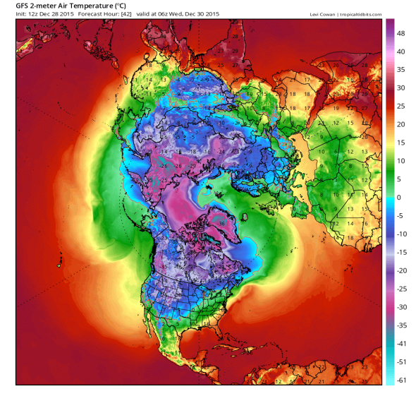
GFS model courtesy of Levi Cowan
This, more than any other extreme weather event in a remarkable year for the climate, feels like something new. This midwinter melt at the North Pole is a preview of what’s to come later this century—in fact, the temperature anomalies match almost exactly with what is predicted. The long-feared worst-case climate change scenario, which, thankfully was made less likely by the Paris agreement earlier this month, projects an ice-free Arctic within decades. Storms like this week’s are exactly the type of events that do the dirty work of ushering in that world. In the meantime, we’re running on the knife’s edge as a civilization, dodging warning signs and hoping for a planetary miracle.