Want to listen to this article out loud? Hear it on Slate Voice.
Houston is in the midst of what appears to be the worst flooding to strike a major U.S. city since the levees broke in New Orleans after Hurricane Katrina in 2005.
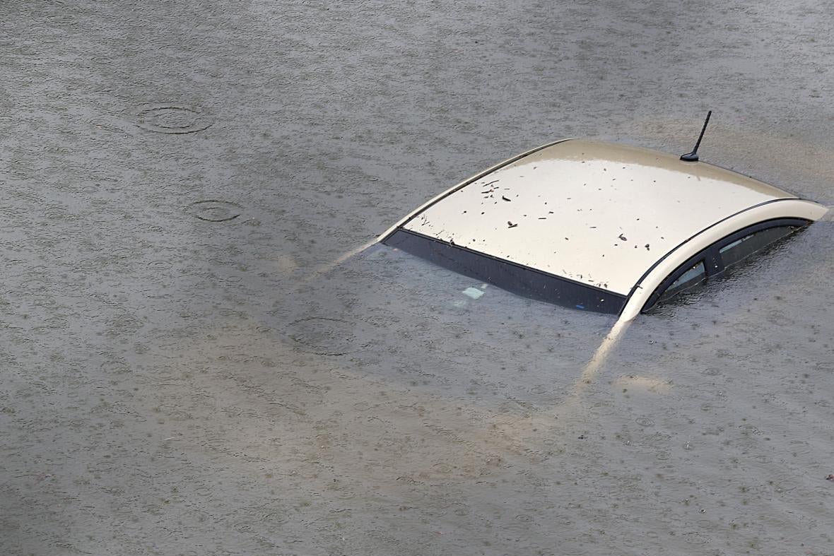
Hurricane Harvey has been downgraded to a tropical storm, but it was never the water from the ocean that Houston had to fear but the water from the sky. And the rain just keeps on coming, even as flooding has rendered major freeways impassable. Buffalo Bayou, the meandering river that passes through the center of the city, is expected to crest 14 feet above its previous record. Overhead video shows vast areas of the city’s single-family home neighborhoods swamped by brown water. Downtown is an island. More rain is projected through Tuesday.
America’s fourth-largest city is still full of people: Citizen flotillas of kayaks and outboards are rescuing Houstonians from cars, trucks, rooftops, and second-floor windows, complementing a severely overwhelmed official relief effort. On Sunday afternoon, emergency service lines were so inundated that callers could only get busy signals, the Houston Chronicle’s Lydia DePillis reported. At one point the wait for 911 was two-and-a-half hours, a Houstonian told Laura Nelson of the Los Angeles Times. Texans are using Twitter to ask people to save their lives. And many of us are wondering who is to blame.
The immediate question is why local officials did not encourage people to evacuate. On Friday, as the Hurricane neared landfall, Gov. Greg Abbott issued a somewhat half-hearted warning to residents along the coast: “Even if an evacuation order hasn’t been issued by your local official, if you’re in an area between Corpus Christi and Houston, you need to strongly consider evacuating.”
But that suggestion was contradicted by local officials in Houston and its many suburban cities, who said, basically: This isn’t the Jersey Shore or the Outer Banks or even New Orleans. “You can’t put—in the city of Houston—2.4 million people on the road,” Houston Mayor Sylvester Turner said at a press conference on Sunday, defending the decision. Together with surrounding Harris County, 6.5 million people would have had to leave—including tens of thousands of people without transportation and more than 550,000 undocumented immigrants who fear the federal and state governments. Many Houstonians remember 2005, when an attempted evacuation for Hurricane Rita created the worst traffic jam in the city’s history and killed as many people as the hurricane itself—through heat stroke, and a bus that caught fire. The freeways where motorists sat stranded during Rita are underwater now. During last year’s floods, most deaths also occurred in cars.
One underlying cause of Houston’s suffering is that developers and town officials in Harris County, which contains Houston, have for years advocated the development of the wetlands and prairies around the city—land that had long served to absorb the rainwater that now overwhelms the region’s sewers and streams every year. The flood-absorbent grasslands of the Katy Prairie have been cut by three-quarters over the past few decades as Houston sprawled west. The state played along, funding expansion of I-10, “the Katy Freeway,” and another road, the Grand Parkway, which further opened that land up for development. To make matters worse, money-hungry officials also encouraged development in low-lying, flood-prone areas without regard to future risk. There have been more than 7,000 units built in the hundred-year floodplain since 2010, according to a ProPublica/Texas Tribune analysis. Efforts to reform the city’s building codes have been met with strong resistance in an area where homebuilding has been a major economic engine.
Last year, the longtime head of the Harris County flood control district, Mike Talbott, told ProPublica that his agency had no plans to study the impact of climate change on the region’s flooding problems. Here’s a quote from that article, which is well worth reading in full:
Of the astonishing frequency of huge floods the city has been getting, he said, “I don’t think it’s the new normal.” He also criticized scientists and conservationists for being “anti-development.”
“They have an agenda … their agenda to protect the environment overrides common sense,” he said.
Still, the debates over evacuation and development are spurious confronted with a storm this size, and the trend it represents: a strength and frequency of weather events that challenge all previous notions of risk assessment. This is the third straight year that Houston has endured a devastating, once-in-a-lifetime flood. There were the Memorial Day floods in 2015 and the Tax Day floods in 2016. Together the storms killed 16 people and caused more than $1 billion in damage. More than a third of the properties that flooded in Houston’s 2015 Memorial Day floods were located outside the “hundred-year floodplain,” the zone in which FEMA requires homeowners with government-backed mortgages to elevate homes or buy flood insurance. Now with Harvey, Houston has been hit with six “hundred-year storms” since 1989.
Early Sunday, the National Weather Service essentially threw up its hands:
Even the president seemed to have a sense that something extraordinary was afoot. “We have an all out effort going, and going well!” the president tweeted from Camp David on Sunday morning. “Even experts say they’ve never seen one like this,” he added later.
Here’s how the Washington Post’s Capital Weather Gang described it:
The total rainfall from the storm is likely to tally up to a widespread 15 to 30 inches, with a few localized spots picking up 50 inches or more. Many textbooks have the 60-inch mark as a once-in-a-million-year recurrence interval, meaning that if any spots had that amount of rainfall, they would essentially be dealing with a once-in-a-million-year event.
Cities are built around levels of expected risk, ascertained by residents and businesses and enforced by finance and insurance and government. Will a bank loan you the money to build that house, or to buy it? Will an insurer back those loans? Will a city official permit it? It now seems clear that in the case of Houston, those estimates—forged on years of historical data—have been decimated by the planet’s changing atmosphere.
It does not make sense to say climate change “caused” a hurricane. But, as the climate scientist Michael Mann wrote, “it exacerbates several characteristics of the storm in a way that greatly increased the risk of damage and loss of life.” And at the Atlantic, Rob Meyer has a thoughtful evaluation of the ways in which climate change has enabled larger, more dangerous, faster-growing storms. The oil capital of the world drowned by an atmosphere teeming with greenhouse gases.
The science isn’t certain, of course. But the extremity of the storm is. No land-use regime can proof a city for 50 inches of rain. Perhaps it is possible to move 6.5 million people out in 48 hours, but we have yet to accomplish it. The problem Houston has is more severe. Until the modern era, it was routine for disasters—mostly fire, flood, and pestilence—to serve as checks on the growth of urban centers. We have almost forgotten that used to happen, but it’s not unheard of: The population of New Orleans fell by half after Katrina, and remains about 15 percent smaller than it was in 2005. (About 100,000 of those people settled in Houston.) After three straight years of catastrophic floods, America’s fastest-growing city may be reaching a turning point.